New Ideas and Critical review of Middle Eocene Gercus Formation, Kurdistan Region, NE-Iraq
Kamal Haji Karim1, Mushir M. Baziany1 and Polla A Khanaq2
1Department of Geology, College of Science, University of Sulaimani, Kurdistan Region, Iraq (KRI)
2 Kurdistan Institution for Strategic Studies and Scientific Research,
Corresponding author: [email protected]
In Iraq, Gercus Formation (Middle Eocene) crops out now near boundary between Low and High Folded Zone and generally consisted of red claystone and sandstone with occasional beds of conglomerate. Lithologically, it changes toward the southwest to carbonate-siliclastics of either Khurmala or Aliji Formations inside the Low Folded Zone. All previous studies have concluded that the environment of the formation was fluvial and deltaic of continental mollasse facies with possible some shallow marine sediments at its lower part. Conversely, the most recent two studies have assigned two different, opposite environments of the formation, which are deep marine (turbidite facies), and desert environments. The aims of the present study are critical and objective analysis of the previous studies in addition to introduction of new ideas that are opposite to deep marine and aeolian environments. The study gives many evidences and features for justification of the introduced new ideas, which are revealing the actual environment of the formation. This reveal is depended on the field and regional correlation in areas of boundary between High and Low Folded Zone (area of exposure of Gercus Formation) and area of Imbricated and Thrust Zone where its equivalent in age and facies (unit five of Red Bed Series) is exposed. The present study supports neither the deep marine turbidite nor the desert erg system of the previous studies. The present study proves that the Gercus Formation consists of the distal alluvial fan and its proximal part is unit five of Red Bed.
Key Words: Gercus Formation, turbidite sediment, Red Bed Series, Aeolian sediments, continental sediments
Introduction
The studied area is located between Low and High Folded Zones in the Kurdistan Region, northeast Iraq where Gercus Formation extensively exposed between Paleocene- Early Eocene Sinjar (Khurmala) and Middle –Upper Eocene Pila Spi Formation (Fig.1). According to Bellen et al. (1959) [1], the formation is first defined in the southeast Turkey by J H Maxson, in 1936 at north of Midyat. The same author added that R.Wetzel has chosen a supplementary type section, in Iraq, Dohuk, between lat. 36° 52′ 52″ N, long. 43° 00′ 50″ E, and lat. 36° 52′ 27″ N, long. 43° 00′ 36″ E. Al-Rawi, (1980) [2] studied the petrology and sedimentology of Gercus Formation in Shaqlawa and Darbandikhan area.
Al-Rawi (1983) [3] studied the origin of red color in the Gercus Formation in the studied area and assigned fluvial environment for the formation. Al-Qayim and Al-Shaibani (1991) [4], concluded that sediments of Gercus Formation deposited in a clastic dominated tidal flat. Based on main lithological distribution, Ameen (1998) [5] divided the formation into three parts (lower, middle and upper parts). Ameen (2006) [6] inferred depositional environment to be braided delta plain that is prevailed by fresh water influx and flooding by marine water. For justification of this environment, he showed many evidence such as mud cracks, marine sediments (marl) and laminated sandstone, which deposited in upper flow regime.
The most interesting and new ideas belong to two papers of Al-Mashaikie et al. (2013) [7] and Hussain and Aghwan, (2015) [8] in which two different and opposite origins of the formation is concluded and discussed in detail. The first one summarized that the Gercus Formation consists of distal-shelf turbidites (clay dominated), slope-marine turbidite (sand dominated) and distal (deep) turbidite (clay dominated) which deposited in the basin plain. The article added that these turbidites represent the sedimentation of the gravity flows and turbidity currents in submarine fans, which display graded beddings, ball and pillows, slump, slide and disturbed beds. In this latter paper, it further added that Gercus Formation represents continuation of the turbidity cyclic repetitions of the Kolosh and both have gradational boundary.
The second paper emphasized on the aeolian, fluvial and lacustrine facies associations as the main constituent of the Gercus Formation. It is added that aeolian facies consists of deflation lags/desert pavements, aeolian sand sheet, aeolian dune, aeolian bimodal and interdune deposits.
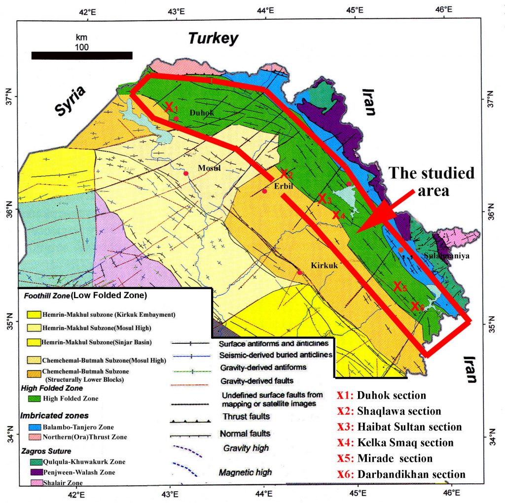 Figure-1: Tectonic map of Northern Iraq, modified from Jassim and Goff (2006) [9] the red encircled area represents location of the studied area and width of clastic deposition during Early Eocene
Methodology
The methods of the study are selected to aid or refuse the above ideas and to introduce new ones that update the information about the formation. Twenty samples are taken from Haibat Sultan section from the claystone for nannofossils and planktonic foramiferals analyses. These analyses are important for deciding if the formation is a deep marine or not, because fine deep marine sediments contain both nannofossil and planktonic foraminifras. The authors conducted extensive field study in Darbandikhan and Kalka Smaq areas for finding wind sediment and structures, contain arenite and have more angle of response than those of water. The field study is not restricted in the area of the boundary between High and Low Folded Zones (in this study it is called southern area) but extended to the thrust and Imbricated Zones (in this study it is called northern area) for finding lateral facies change toward northwest.
Result
Absence of deep marine fossils content
Twenty samples are taken form the most fine clastics (red clay stones) from Haibat Sultan and Mirade sections for nannofossils, planktonic forams analyses and ostracodes. Cooked samples and smear slides are prepared for this purpose. The result of the inspection of slides was negative as neither nannofossils nor planktonic forams are found in the samples. Even the ostracodes are not found in all samples. This property is characteristics of all the continental red beds such as Red Bed Series, Merga Red Beds, Upper Fars and Lower Bakhtiari Formation.
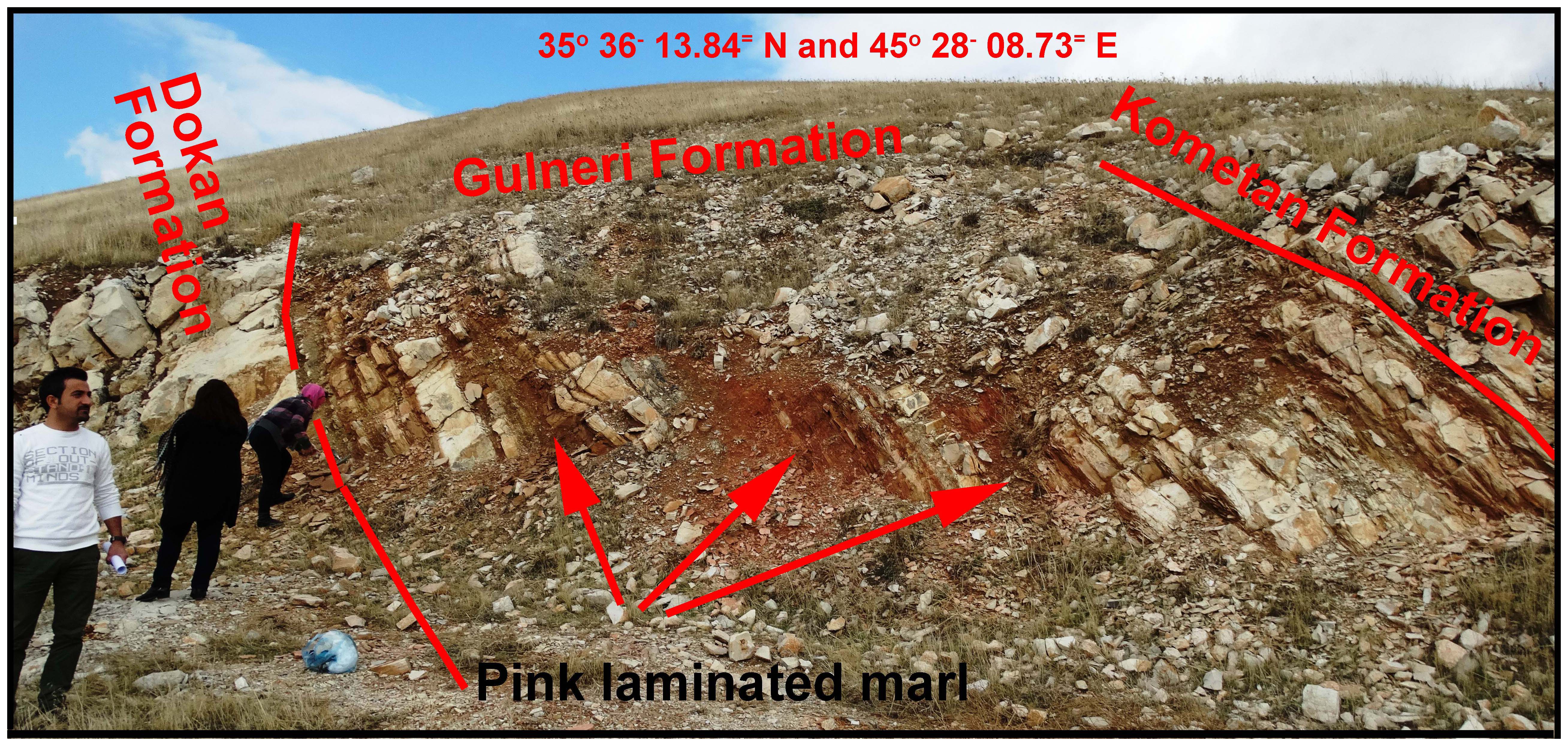
Correlation of the conformable units in the Foreland basin
The field study to find the equivalent of Gercus Formation is the most difficult task. This is because the upper boundary, with Pila Spi or Avanah Formation, according to most studies, is unconformable which is represented by thick bed of polygenetic conglomerate. According to Karim et al. (2008) [10] the clastic influx from the source area, was stopped due to separation of the foreland basin into two basins during Middle Eocene. In the southern and northern basins, the Pila Spi and Walash-Naoperdan Series are deposited respectively. Therefore, the correlation is not included sediment older than middle Eocene due to the unconformity while the units of Paleocene- Early Eocene are included in the correlation due to absence of unconformity.
The field tracing and previous studies (such as Barzinjy, 2005) [11] proved that the unit five of Red Bed Series, as a proximal facies of Early Eocene, changes along paleo-slop to Gercus Formation. In the former paper, it has discussed in detail how all stratigraphic units of the Campanian to Middle Eocene are deposited in Zagros Foreland Basin. He showed that some of them deposited in coastal area as continental sediment other deposited in deep marine environment. Barzinjy (2005) [11] and Karim (2010) [12] considered the unit five of Red Bed Series (boulder Conglomerate) and Gercus Formation as proximal and distal part of the same alluvial fans respectively. They assumed that both are lateral facies change of each other. The field study of the present paper, in the studied area (figure 1) confirms the above facies change and the related correlation chart show other facies change of other units of Red Bed Series (Fig. 2).
Sediment fills and tectonic uplift of Paleocene basin
It is well known that Kolosh Formation is deep marine sediment of turbidities origin, the direct evidence for this environment is its content of abundant and species richness of planktonic foraminifera and nannofossils which are interbedded with turbidites sandstone. These fossils are observable under microscope when extracted by cooking from marl layers of the Bouma Sequence. The Formation contains very clear graded bedding sedimentary structures and some intervals contain benthonic forams and rare gastropods or pelecypods.
During Paleocene, the basin of latter formation is filled with sediments of about 500m in the depocenter. At the end of Paleocene, due to the tectonic uplift and sediment fills, the basin suffered from shallowing. This process led to deposition of carbonate sediments of Sinjar (or Khurmala) Formations in the most places in the basin. After deposition of this unit, the basin became continental alluvial fan and delta in which Gercus Formation was deposited as intermediate facies between Red Bed Series and Khurmala Formation. Toward deeper part of the basin Khurmala facially and laterally changed to Aliji Formation.
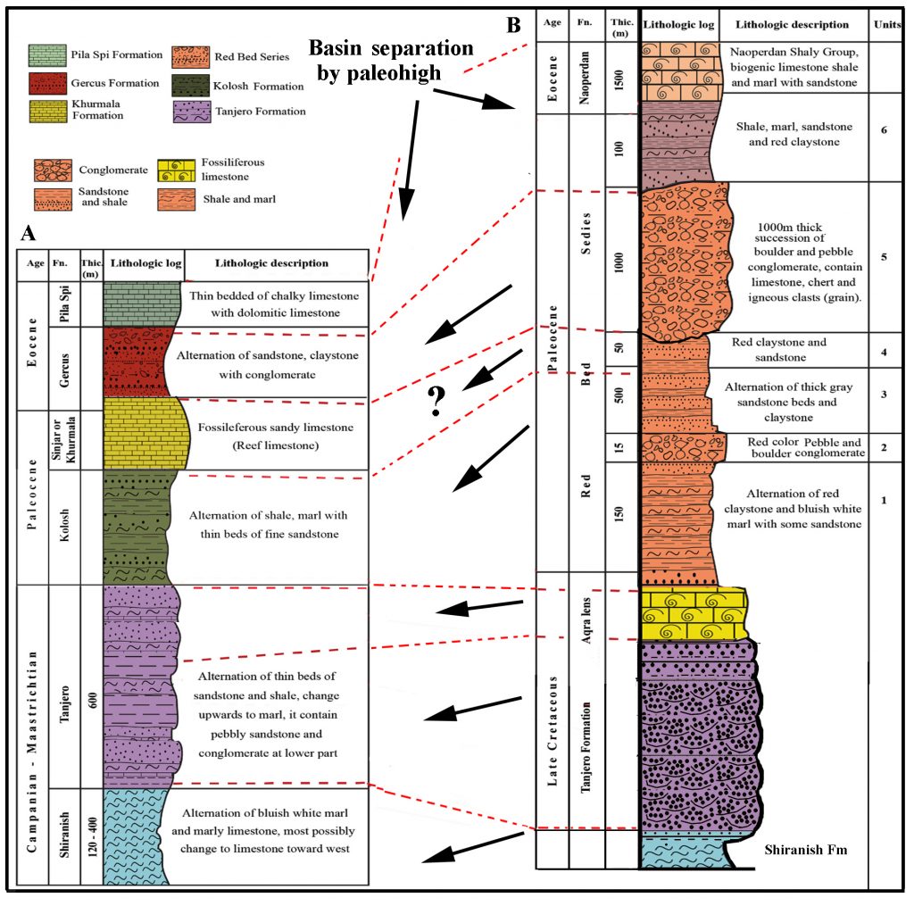 Figure-2: Correlation of the units of Red Bed Series (in side Imbricate Zone) with the formations in the boundary between High and Low Folded Zones in S ulaimani Governorate. The correlation depends on lateral facies change.
Gercus and Khurmala facies interchange
According to Bellen et al. (1959) [1], Khurmala Formation is about 185 m thick, overlain, and underlain by Avanah and Kolosh Formations respectively and its boundary with latter Formation is unconformable. It consists of dolomite and dolomitic limestone with interbeds of clastic sediments. The stratigraphic position and high thickness (for lagoonal unit) indicated that it contain equivalent of Gercus Formation which means that it changes facially to Khurmala Formation. Karim et al. (2016) [13] have observed this facies change across both limbs of Sagrma anticline. While Karim et al. (2008) [10] indirectly referred to impossibility of change of Gercus Formation to Avanah Formation due to deposition of Pila Spi and Avanah Formations in the same basin and nearly have same tectonic setting that was different from that of Gercus and Khurmala Formations. In Duhok area, Karim (2015) [14] has concluded that the Kolosh Formation is facially changing to Khurmala Formation, so it can be suggested that the Kolosh, Khurmala and Gercus formations are laterally and vertically have the facies changes interrelation that depend of rate, location, presence or absence of clastic influx. Along road cut 1km to the northeast of Mirade Village (in Darbandikhan area), there is no any representation of the Khurmala (or Sinjar) formation and its stratigraphic position occupied by succession of clastic lithology which is more or less similar to Gercus Formation (Fig.3). This clastic succession is discussed by Karim et al. (2018) [15] but till now neither named nor combined with Gercus formation. While according to Bellen et al. (1959) [1], the type section of Khurmala Formation contains neither Gercus Formation nor unconformity, therefore the location of Gercus Formation is occupied by the former formation due to facies change.
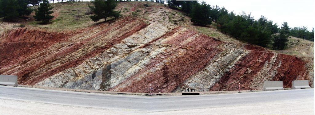 Figure-3: Differently colored beds of Gercus Formation along road cut 1km northwest of Mirade Village between Sulaimani city and Darbandikhan town. In area, there is no Khurmala (or Sinjar Formation).
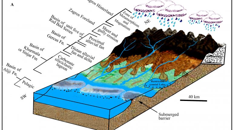
Paleogeographic conceptual model
The model for paleogeographic setting of the Gercus Formation depend on the fieldwork in the studied area (Fig.1) by which the tectonic, lateral and vertical facies change of the Foreland basin is logged from Campanian to Recent. This logging is aided by extensive available outcrops of the stratigraphic units which can be traced facially both along the strike and dip of the strata for tens of kilometers. The literature review supported the model by mutual comparison of lithology, paleocurrent and lithostratigraphy between previous studies and present one. Before the construction of the model, the authors have drawn a valid stratigraphic correlation between stratigraphic units in the Low Folded Zone and their equivalents in the High, Imbricate and Thrust Zones (Fig.2). The important of the correlation is not only included chronostratigraphy but also it is depended on the lateral and vertical facies change in the same basin (Zagros Foreland Basin (Fig.4).The correlation is dependent on the sequence stratigraphy of the present study and previous ones such as Baziany (2009) [16], Ameen (2006) [6] and Barzinjy (2005) [11].

Figure-4: paleogeographic and environmental model of the studied area during Early Eocene (modified from Baziany, 2009) [16]
Discussion
Continental versus deep marine environment of Gercus Formation
Unfortunately, the evidences in the study of Al-Mashaikie et al. (2013) [7] are not direct but all are circumstances that depended on the sedimentary structures. The cited structures are all exist in other units of northern Iraq such as Red Bed series (see Al-Barzinjy, 2005) [11] and they exist too in the Upper Fars, Lower and Upper Bakhtiari Formations. Therefore, if Gercus Formation is a deep marine facies, it means that the foreland basin was not contain continental red clastics which does not agree with tectonic and sedimentology of Foreland basins which contain continental red beds always. Unfortunately, the former paper has not mentioned anything about fossil (planktonic formas, nannofossils and trace fossils) content which are the indisputable fact about the depth and environment of any unit. The absences of these fossils are proof for continental environment of Gercus Formation. Moreover other than fossils, the article has discussed neither the clear mud crack photos of Ameen (2006) [6] (Fig.5A) nor it showed graded bedding sedimentary structures which is the only characteristics structure of turbidite sediments. In the study of Al-Mashaikie et al. (2013) [7], a flute cast is one of the sedimentary structures that is used as indicator of turbidite but this structure is found too in the unit three of the continental Red Bed Series 2km west of Qalachuwalan town in Chuarta area by Karim et al.(2007) [17] (Fig.5B).
Another problem is ignoring the discussion of the red color of Gercus Formation in the former paper. Generally, the deep marine and turbidite sediments have grey or black color due to its content of organic matter while latter Formation has red color, which denotes continental environment in which sediments has been colored red and organic matter decayed by oxygenation. The red color (continental sediments) during Eocene, are not belonging to Zagros belt only but Martın-Martın et al. (2001) [18] accurately documented them in France.
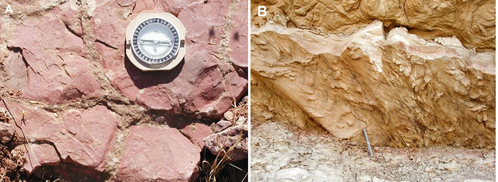 Figure-5: A) Mud cracks filled with sand in Gercus Formation in Haibat Sultan section (Ameen, 2006), B) well developed flute cast of unit three of Red Bed Series (Karim et al., 2007)
Gercus Formation: Desert versus fluvial sediments
Very recently, Hussain and Aghwan (2015) [8] have attributed partly the deposition of Gercus Formation to desert environment and discussed in detail many features and structures to justify the presence of a desert and its sediments during Lower Eocene. This desert environment is completely opposite to the deep basin turbidite of Al-Mashaikie et al. (2013) [7]. The idea and conclusion of desert environment have many weaknesses that make the present study not to aid their conclusions.
These weaknesses are eight; the first is non-distinctiveness of published sedimentary structures in the paper about the desert erg environment of Gercus Formation. The non-distinctiveness is due to presence same structures in Upper and Lower Bakhtiari and Red Bed Series. The second is the drawn stratigraphic column of Gercus Formation in the latter paper (page 2802) is about 60% consists of red claystone, which is characteristic of river environment with riverbed and flood plain sediments (Fig.6). No desert can exist with such abundance of fine clastics (red clay stone and siltstone). Similarly, in the type section Bellen et al. (1959) [1] and Jassim and Goff (2006) [9] have mentioned prevalence of fine clastics in the formation which consist of red and purple shales (red claystone), mudstones, sandy and gritty marls with or without pebbles. In literature Mountney and Jagger (2004) [19] have published a paper about desert aeolian erg margin system of USA during Permian, the thickness of succession is about 200m and it mostly consist of cross bedded sandstone. These latter authors defined the available small amount of purple mudstones, in the succession, as an over bank river deposits.
The third weakness is the different color of different beds of Gercus Formation in most places such south of Sulaimani city (Fig.6B) and Darbandikhan area (Fig.3). These color change neither discussed by Hussain and Aghwan (2015) [8] nor showed how the beds of desert sediments can change color. In the present study, this change considered as another evidence of river sediments that have different color due to derivation from different source area by erosion and transportation to site of depositions. The red color beds are mainly derived from weathered parent rocks which eroded by sheet wash while the gray or blue one is derived from gulley erosion from fresh source rocks of igneous parent rocks.
 Figure-6: Haibat Sultan section is mostly consisting of red claystone and dirty sandstone that are not characteristic of aeolian sediments.
The fourth weakness is Hussain and Aghwan (2015) [8] estimation of the width of Gercus Formation, which showed in the map of the figure (7) to be about 200 km. They have not mentioned how they calculated this width and they modified the map from two papers which are not directly related Gercus Formation. The two papers are Saura et al. (2011) [20] and Aswad et al. (2013) [21] which are related to growth folding of Zagros and Walash volcanic rocks respectively. All calculation in the present study shows that width of Gercus formation is not more than 50 km. When the proximal alluvial fan (unit five of Red Bed Series see Fig. 8) and the shorting are considered, the width of all clastic dominated facies during latter age does not reach 75 kms. In this study the distal fan of the Gercus Formation in Duhok dam site and Sagrma anticline (Qaradagh area) is extend northward to Bamarni and Chwarta areas (as proximal fan or Red Bed Series ) respectively (Fig.7).
Connectively, it is difficult to desert to be formed on relatively narrow and elongate island in the mid of Neo-Tethys sea (or ocean) as shown in Figure (7). This Island was elongating northwest southeast and most possibly stands in the direction of rainy and cloudy wind like present day. Now the area of the study of Hussain and Aghwan (2015) [8], with all surrounding terrestrial lands, has more than 400 mm of annual rainfall but during the Eocene, the present authors think the rainfall was more than 600 mm, which difficult to develop desert, land. In this connection, Rodríguez-López et al (2012) [22] mentioned that most present deserts occur in arid regions that typically experience less than 150 mm annual precipitation. High amount of red claystone is evidence for wet climate in which clay genesis was prevailing giving rise to red sediment. In other side, tectonically, the Eocene was very active time for Zagros development and according to many authors such as Buday (1980) [23], Buday and Jassim (1987) [24], Numan (1997[25], 2000[26], and 2002[27]), Al-Qayim (2000) [28] and Ghasemi and Talbot (2005) [29] the continental colliding was occurred between Iranian and Arabian plates during Eocene. The development of desert needs relatively stable tectonic, therefore the idea of desert, during Eocene, is contradict the idea of the above authors that indicate the most severe uplift and subsidence in the history of the Zagros Orogenic Belt. The finding of Gypsarenite (detrital gypsum) and detrital lignite (Fig.9) at the Duhok Dam site by Baziany (2009) [16] is evidence of high tectonic by which oil had seeped to the surface and high sedimentation had rapidly covered the detrital gypsum for preservation after erosion. Unfortunately the above two clastic sediments are not treated or discussed by Hussain and Aghwan (2015) [8] although the related paper was available from 2010 in www.kurdista-geology.com.
The fifth weakness is the claimed deflation lag pebbles that discussed and photographed in the latter paper. The present paper conclude that they are not lag pebbles but they are normal river bed deposit and the claimed polished surface of the pebbles is due to recent activity of river and rainwater. These activities exposed a half of the pebbles and cleaned it from mineralization coating and sticking particles while the unexposed half (or part) remained with mineralization coating (Fig.10). The two halves of the pebbles are clearly showed on an outcrop of the Gercus Formation by Hussain and Aghwan (2015) [8] in their figure 4, b, c in the page 2806 (see present Fig.10 and 11). In their figure 4c they showed the pebbles after they have picked and removed from the outcrop and they have indicated the two polished and unpolished halves (figure 10 and 11). These polished pebbles can be found in all conglomerates and even recent gravely stream beds (Fig.12).
The present paper, suggest that the testing for indication of the polished surfaces inside a bed of conglomerate or pebbly sandstone must not be taken from exposed surface of the bed. However, they taken deep inside the bed by digging a hole and then fresh samples excavated 1 meter, at least, below surface with indication of north on the samples. After taking the fresh samples, the pebbles cleaned by weak acid for removing mineralization coating and other sticking materials. After the cleaning, the pebbles are tested for the presence or absence of polished surface or ventifacts during Eocene. Unfortunately, it appears from the methodology and the figures of latter paper that the samples are not taken in fresh layers as can be seen from the latter two figures.
 Figure-7: The paleogeographic location of the Gercus Formation with in the Neo-Tethys by Hussain and Aghwan (2015) [8].
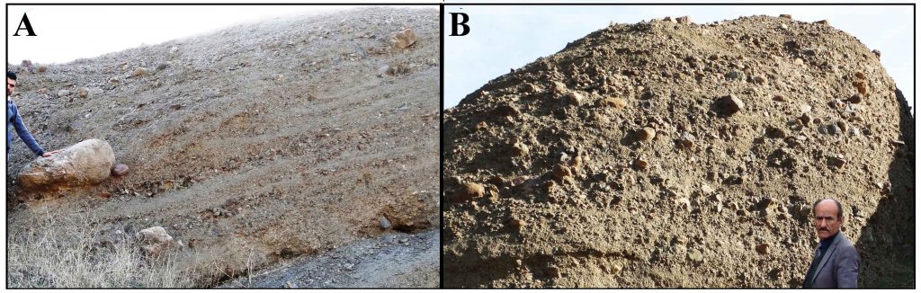 Figure-8: Unit five of Red Bed Series (very coarse proximal alluvial fan during Eocene) in Chwarta area, which is correlative, in time and space, with Gercus formation, A) A block of limestone in the series, B) Boulders of chert and limestone in the series at 3 km south of Chwarta town.
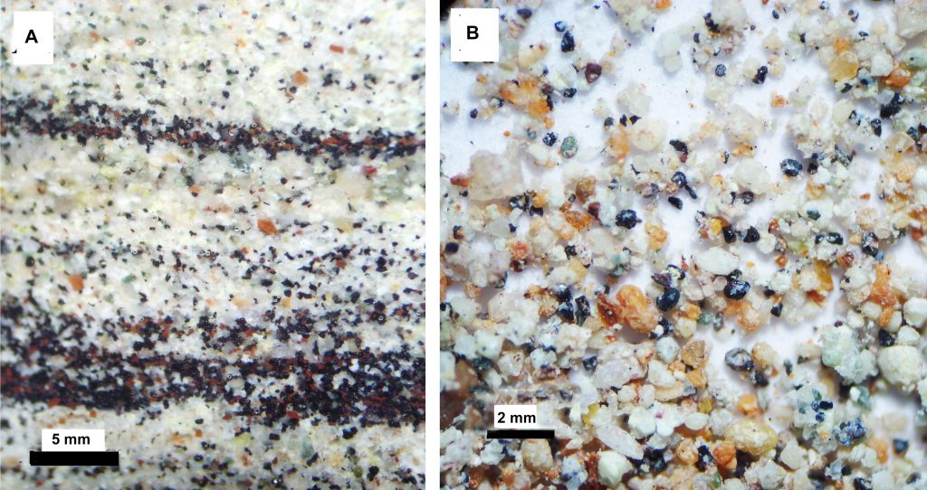 Figure-9: detrital gypsum and bitumen in the middle part of Gercus Formation which is exposed along southwest coast of Duhok dam, A) thin section shows laminated bitumen and gypsum clasts, B) disintegrated mixture of both clasts.
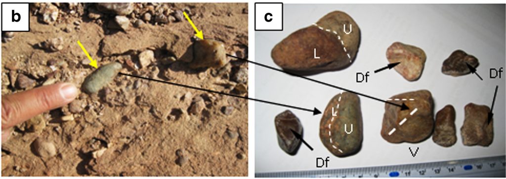 Figure-10: The figure4 b and c of Hussain and Aghwan (2015) [8] shows polished surface and ventifacts which is not supported in the present study. U: polished surface, L: unpolished surface, V: Ventifact, and Df: depressed facets
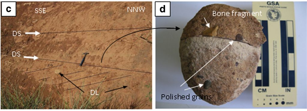 Figure-11: the figure 6 c and d of Hussain and Aghwan (2015) [8] shows the wind deflation surface and polished surface which is not supported in the present study and it is interpreted as fluvial cross bedding which indicating paleocurrent of southeast. DL: Deflation lag, DS: deflation surfaces.
The sixth weakness is the published photo of ventifact and depressed facets by Hussain and Aghwan (2015) [8], are not clear (Fig.10) so they cannot convince the reader about the erosional work of wind. If the pebbles with ventifacts, polished and depressed surfaces are true, the paleo-wind direction can be indicated automatically by the authors but unfortunately, nothing was mentioned about prevailing paleo-wind direction. Even the authors have not indicated the north direction on the pebbles and outcrops that show ventifacts and polished pebbles. Some of their photographed pebbles show imbrication, which is a characteristic of fluvial deposits.
The seventh weakness is desert pavement that shown by the latter paper in the figure 13. In the present study, it reinterpreted as river channel deposits which indicated by a green lines as lensoidal body of conglomerate. The channel is clear from planner upper surface and lower concave surface (only a half of the channel is shown). The two pebbles are belonging to pebbly sandstone which exists in most fluvial sediments and deposited when a newer channels of sand has descended very close to older conglomerate ones. Due to the closeness, some pebbles, from the former one, fall into channel of the latter one.
The eighth weakness is absence of clean sandstone (lithic arenite or quartz arenite) in the Gercus formation. Neither the latter paper nor the present one have record this type of sandstone in the formation. Arenite matrix is mainly calcite or silica cement and it is the main sandstone of desert due to high energy and wind sorting of fine particles. Relatedly, (Chandler, 1988) [301] has mentioned abundance of sandstone in desert environment in certain age.
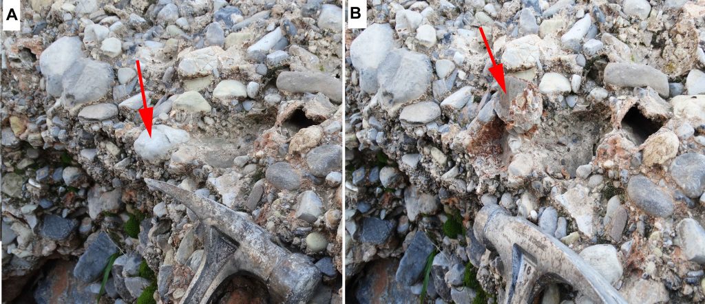 Figure-12: Recent alluvial pebbles in Chaqchaq stream show polished and unpolished surface of the exposed and buried halves respectively. A) The arrow shows exposed polished half, B) Unpolished surface of buried (unexposed) half.
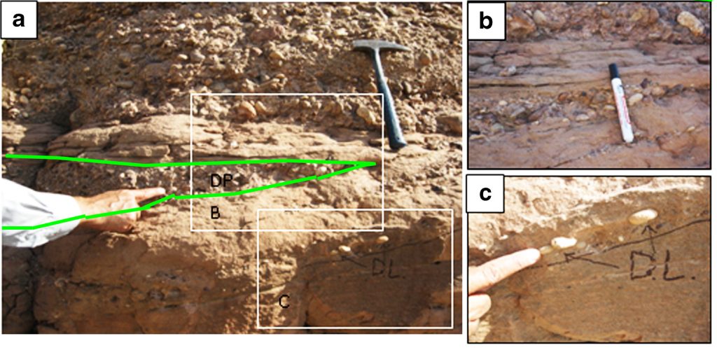 Figure-13: The figure3 a, b and c of Hussain and Aghwan (2015) [8] published to show desert pavement but in the present study it reinterpreted as river channel deposits which indicated by a green lines as lensoidal body of conglomerate. D.L: deflation lag
Conclusions
This paper has the following conclusions
- The present study does not support either the deep marine turbidite or the desert erg system of the previous studies.
- All the evidence of the deep marine turbidite and desert environment are neither unique nor objective. They are circumstance evidence and can be applied to other clastics dominate stratigraphic units such as Red Bed Series, Upper and Lower Bakhtiari in northern Iraq.
- The Gercus Formation consists of the distal alluvial fan and fan delta. Its proximal part is unit five of Red Bed Series which has no more than 75 km width
- The prevalence of fine red clastics (claystone and siltstone), variable bed colors and absence of deep marine fossils does not agree with deep marine
- Abundance red claystone and absence of arenite do not aid desert environment
References
[1] Bellen, R. C. Van, Dunnington, H. V., Wetzel, R. and Morton, D., 1959. Lexique Stratigraphique, Interntional. Asie, Iraq, Vol. 3c. 10a, 333 p.
[2] Al-Rawi, Y., 1980. Petrology and Sedimentology of the Gercus Red Bed Formation (Eocene) NE Iraq. Iraqi J. Sci.21, 1.
[3] Al-Rawi Y (1983) Origin of red color in the Gercus formation (Eocene), Northeastern Iraq, Geology, Volume, July 1983, Pages 177–192.
[4] Al-Qayim, B. and Al-Shaibani S., 1991. A bimodal tidal depositional system of the Gercus Formation, Shqlawa area Northeastern Iraq. Salahadin University, Jour. Sci.
[5] Ameen, B. M., 1998. Sedimentological Study of Gercus Formation in NE–Iraq Un. Pub. Ms.c. thesis, Unv. Baghdad, 103p.
[6] Ameen, B. M. (2006) Sequence Stratigraphy of Gercus Formation (Middle Eocene) in Sulaimaniya area, NE-Iraq, Iraqi Journal of Earth Science, Vo.6, No.2, p.23-32, 2006
[7] Al-Mashaikie, S Z., Al-Azzawi, A T. A and Kadhum A K. (2013) Lithofacies Architecture of the Gercus Formation in Jabal Haibat Sultan, NE Iraq; New Concept of Lithostratigraphy and Depositional Environment, Journal of Environment and Earth Science Vol. 3, No.12.
[8] Hussain S H. and Aghwan, T A (2015) Sedimentology and evolution of a foreland desert basin, Middle Eocene Gercus Formation (North and Northeastern Iraq), Arabian Journal of Geosciences May, Volume 8, Issue 5, pp 2799-2830.
[9] Jassim, S.Z. and Goff, J.C., 2006. Geology of Iraq. Published by Dolin, Prague and Moravian Museun, Berno, 341p.
[10] Karim, K. H, Al-Barzinjy, S.T. and Ameen and B. M.(2008) History and Geological Setting of Intermontane Basin in the Zagros Fold-Thrust Belt, Kurdistan Region, NE-Iraq Kamal H. Karim. Iraqi Bulletin of Geology and Mining Vo.4, No.1, P.21-33, 2008.
[11] Barzinjy, S. T. M., 2005. Stratigraphy and Basin Analysis of Red Bed Series from Northeastern Iraq, Kurdistan Region. Unpublished Ph.D. thesis, University of Sulaimani, 159p.
[12] Karim, K. H (2010) Modification of the time-expanded stratigraphic column of North East Iraq during Cretaceous and Tertiary. Published in: Petroleum Geology of Iraq (First Symposium, 21-22april, Baghdad, Abstract book, p4.
[13] Karim K H, Al- Hakari S HS, Kharajiany S O. A and Khanaqa P A.2016 Surface analysis and critical review of Darbandikhan (Khanaqin fault), Kurdistan Region, NE-Iraq Kurdistan Acadimicis Journal (KAJ), 12(1): 61-75.
[14] Karim, K.H. (2015) Facies Changes Between Kolosh and Sinjar Formations Along Zagros Fold–Thrust Belt in Iraqi Kurdistan Region. Journal of Geography and Geology; Vol. 8, No. 1; 2016.
[15]Karim, K.H., Daud, H.S. and Kuradawy, AR (2018) Record of Khurmala Formation (Late Paleocene-Early Eocene) in the Sulaimani Governorate, Kurdistan Region, Northeast Iraq, accepted for publication in Iraqi Geological Journal (IGJ).
[16] Baziany, M. M. (2009), Geology of bedded Gypsum in the Gercus Formation (Early-Middle Eocene) in Dohuk area, Kurdistan Region, Northern Iraq. The Proceedings of third International Conferences on Geo-Resources of the Middle East and North Africa (GRMENA-III), Egypt, Cairo University, Vol.1.
[17] Karim, K. H., Surdashy A. M. and S. T. Al-Barzinjy (2007) Concurrent and lateral deposition of flysch and molasses in the foreland basin of Upper Cretaceous and Palaeocene from NE-Iraq, Kurdistan Region, GERMENA II, 2007, P.757-769.
[18] Martın-Martın, M., Rey, J. Alcala-Garcia F. J., Antoine P.O. (2001) Tectonic controls on the deposits of a foreland basin: An example from the Eocene Corbières-Minervois basin, France, Basin research, vol13, p.419-433
[19] Mountney N. P. and Jagger, A (2004) Stratigraphic evolution of an aeolian erg margin system: the Permian Cedar Mesa Sandstone, SE Utah, USA, Sedimentology, 51, 713–743
[20] Saura E, Vergés J, Homke S, Blanc E, Serra-Kiel J, Bernaola G, Casciello E, Fernández N, Romaire I, Casini G, Embry JC, Sharp IR, Hunt DW(2011) Basin architecture and growth folding of the NW Zagros early foreland basin during the Late Cretaceous and early Tertiary. J. Geol Soc Lond 168: 235–250.
[21] Aswad KJ, Al Samman AHM, Aziz NR, Koyi HA (2013) The geochronology and petrogenesis of Walash volcanic rocks, Mawat nappes: constrains on the evolution of the northwestern Zagros suture zone, Kurdistan Region, Iraq. Arab J Geosci 28:1–30.
[22] Rodríguez-López JP, Melendez N, De Boer PL, Soria AR (2012) Control on marine-erg margin cycle variability: aeolian-marine interaction in the mid-Cretaceous Iberian Desert System, Spain. Sedimentology 59:466–501.
[23] Buday, T. C, 1980. Regional Geology of Iraq: Vol. 1, Stratigraphy, I. I. M Kassab and S. Z. Jassim (Eds) D. G. Geol. Surv. Min. Invest. Pub. 445p.
[24]Buday, T. and Jassim, S. Z., 1987. The Regional geology of Iraq: Tectonics, Magmatism and Metamorphism. I.I. Kassab and M.J. Abbas (Eds), Baghdad, 445 p.
[25] Numan, N. M. S., 1997. A plate tectonic scenario for the Phanerozoic succession in Iraq. Iraqi Geological Journal, Vol.30, N. 2, p.85-110.
[26] Numan, N. M. S., 2000. Discussion of “dextral transpression in the Late Cretaceous continental collision, Sanandaj–Sirjan Zone, Western Iraq”. Journal of Structural Geology, Vol.22, No.8. p.1125–1139. University Press, pp.197.
[27] Numan, N. M. S. and Al-Azzawi, N.K.2002 Progressive versus paroxysmal Alpine folding in Sinjar Anticline, North-western Iraq. Iraqi Jour. Earth of Sci., Vol. 2, No.2, p.59-69.
[28] Al-Qayim, B., 2000. Sedimentation and tectonic environment of the Suwais Red Beds, NE-Margin of the Arabian plate-5th international conference on the geology of the Arab world, Egypt. Abstract book, p.112.
[29] Ghasemi, A., Talbot C.J., 2005. A new tectonic scenario for the Sanandaj–Sirjan Zone (Iran).Journal of Asian Earth Sciences ,vol. xx, p. 1–11..
[30] Chandler F.W. (1988) Quartz arenites: review and interpretation, Sedimentary Geology 58(2- Read more about New Ideas and Critical review of Middle Eocene Gercus Formation, Kurdistan Region, NE-Iraq …