EVIDENCE OF TEMPESTITE AND POSSIBLE TURBIDITE IN THE MIDDLE MIOCENE LAGOONAL DEPOSITS OF LOWER FARS FORMATION, KURDISTAN REGION, NE-IRAQ
Bakhtiar Mohamad Ameen and Kamal Haji Karim
University of Sulaimani, college of science, Department of Geology
Published In: GRMENA 3, annual geological conference , Cairo, Egypt
ABSTRACT
The Lower Fars (Fatha) Formation is deposited in Middle Miocene evaportitic lagoon and has widespread outcrops in the northeastern Iraq. This area constitutes the basin periphery, where the formation consists of cyclic alternation of clastics, carbonate and evaporites rocks while it changes mostly to carbonate and evaporites in the basin center. The formation previously analyzed either as deposits of sabkha or clam and shallow restricted lagoon. The basin was a semi-closed lagoon which occupying most of Iraq and southwestern Iran. The clastic beds of the formation, near the basin periphery, especially the sandstones of the middle part are studied in the field which shows many signals of deposition by storm generated currents. In the studied area, these signals are very strong in some place while week in others which are represented by hummocky cross stratification, sole marks (striations, groove marks, flute casts), skolithos trace fossils, rip up clasts, layer truncation and flaser beds. The normal graded beds are changing; upwards to toward to fine sandstone which contains ripple marks the top and at the top ended by mudstone. These characteristics are more or less similar to model for tempestites but the model of turbidite is not excluded. These new features are very important for establishment new paleogeographic configuration and depositional processes of the basin which refuse deposition in clam lagoon or sabkha environments of the previous studies while aid deposition in high topography active evaporitic foreland basin which highly affected by influx of river freshwater.
INTRODUCTION
Lower Fars Formation is middle Miocene unit, which crops out within the Low Folded Zone of Iraq and southwestern Iran (Fig.1). It stretches as more or less narrow northwest-southeast belt with in the two countries (Buday, 1980). The formation mainly consists of alternation of evaporites (gypsum and anhydrite), marl (calcareous shale) sandstone and red claystone with possible limestone (Bellen et al.1959, Jassim and Goff, 2006). The sandstone and red claystone beds are exposed only in the periphery of the basin while the evaporites, carbonate and marl occur mainly in the centre of the basin (Fig.2). The studied area (north east Iraq) is representing the basin periphery, as indicated by Dunnington (1958) especially the area south of Dokan and Darbandikhan towns. At these area thick succession of sandstone and marl with occasional red claystone are exposed which studied in this work (Fig.3). The sandstone shows much evidence of tempestite and possible turbidite. In the literature, Karim, (2006) found many evidence of tempestite in the lower siliciclastic part and boiclastic successions of the upper part of Tanjero Formation. In Iran, Mohseni and Al-Aasm (2004) are studied tempestite in the carbonate-siliciclastic succession of Paleogene of Zagros basin from southwest of Iran.
GEOLOGICAL SETTING
The studied area is mainly located at the boundary between High and Low Folded Zones Buday (1980), Buday and Jassim (1987). The studies area bounded at northeast by high amplitude anticlines inside High Folded Zone which gradually change to low amplitude anticline inside the Low Folded Zone. The Lower Fars (Fatha) Formation is well exposed in the lower parts of the southwestern limb of the anticlines such as Zimnako, Gulan, Sagrma, Darbandi Bazian, Qishlagh and Haibat Sultan (Fig.3A and 10). These localities are representing proximal area of the basin which is close to source area. In these areas, the outcrop of the formation form iron flat and stratigraphic ribbons geomorphologic features (Fig.3A). The basin of the formation is developed from the basin fill of the Neo-Tethys and colliding of the Iranian and Arabian plates. Karim (2004) has included the basin of Lower Fars Formation in the late Zagros foreland basin while included that of Tanjero and Kolosh Formation in the early foreland basin. Busson and Schreiber (1997) collected many studies that concerned with evaporites in the foreland basin in the Europe and western Mediterranean during Tertiary.
In the studied area the Lower Fars Formation underlies directly the Pila Spi Formation and overlain by Injana Formation unconformably and conformably respectively.(Ameen, 2006) mentioned that the sediments of Lower Fars Formation are deposited in shallow basin environments with significant effects of climate. According to these authors, the sediments were delivered to the delta by river floods from the source area then deposit in shelf environment (or clastic dominated shelf). From these places the sediments were reworked into deeper water by
 Figure 1: A: Location map of the studied area and outcrops distribution of the Lower Fars (Fatha) Formation (modified from Sissakian, 2000). B: Isopach-Facies map of Lower Fars Formation (Dunnington, 1958).
 Figure 2: General view of the Lower Fars (Fatha) in the proximal area showing main lithology, M: Marl, S: Sandstone, R: Red clay stone, G: Gypsum or anhydrite.
Tempestite sediments in the literature
Tempestite is storm deposit, which shows evidence of violent disturbance of pr-existing sediments, followed by their rapid re-deposition in shallow environments (Ager, 1974). Walker, (1984) showed by diagram that storm can rework sediment of the shelf and redeposited it either as tempestite (in shallow water) or as turbidite in deeper water (Fig.4). According to Einsele (2000) tempestites are sheet-like sand, silt and mud beds on considerable lateral extension. They are formed by storm wave, which have strong impact of subtidal sediments by stirring up sand and pebbles, seaweed, various shells debris and fine grain materials. After the storm has waned, the suspended material is re-deposited either directly at the site of wave erosion (site of reworking as tempestite) or transported by suspension into deeper water and deposited as turbidite. He adds that, the grain size of tempestite varies greatly. They range from coarse-grained sand and gravel to silt and mud. The same grain sizes also appear in reworked carbonate sediments such as bioclast sandstone, wackestone and packstone. Goldring (1999) differentiated the tempestite from storm beds by the fact that both distal and proximal tempestite have greater extend which more than one km while storm beds have lesser extend. In Lower Fars Formation the sandstone that bears the evidence of tempestite has the extent of more that 5km.
According to the same author tempestite requires either terrigenous sediment influx or significant biogenic carbonate production, which must not be diluted by siliciclastic. Tempestites probably are formed during sea level fall and well preserved when deposited at the lowest sea level stand. According to Einsele (1998, 2000) tempestites deposited close to the coastline are called proximal tempestite. Those deposited basin ward at great distance from their sediment sources are called distal tempestite. The proximal tempestite facies contains large scale hummocky cross stratification and has no muddy interbeds. The storms and currents erode and mix sediment with water in prodelta area, then transport them to deeper water (Fig.4). This case is similar to that mentioned to Bhattacharya and Willis (2001) in their study of lowstand delta in Frontier Formation, USA.
Field evidence for tempestite in Lower Fars Formation
Many lines of evidence exist in the lower part of Lower Fars Formation proving that the lower part of the formation (at basin boundary) had been deposited in shallow, storm dominated lagoon. These are:
1. Existence of hummocky cross stratification which according to Tucker (1991) this structure is characterized by gently curved, low angle(less than15 degrees) cross laminations. The lamine are arranged in convex-upward (hummock) and concave downward (swale) pattern with the erosional lower boundary of the sets. The laminae are nearly parallel to the erosional surface and thicken laterally which giving fan-like shape. All these characteristics only can be seen when three-dimension exposures are available.
Walker, (1984) mentioned that in core samples, the criteria for distinguishing hummocky cross stratification are the intersected low angle laminations and bioturbated mudstones. These lamination and bioturbation are very common in the middle part of Lower Fars Formation at the east of Koya. In the Lower Fars Formation similar structures are found in the middle part of the formation. This part is deposited in the basin, at an area that is in proximal area (periphery of basin). But showing them by photos failed due to the faintness and largeness of the hummocky cross stratification. Moreover, Walker, (1984, p.200) mentioned association of Skolithos with Hummocky cross stratification. He added that reworking of pre-existing sediment by storm form escape trace fossil (Fig.8). They possibly represent the escape burrow of organisms that buried rapidly during the storm event and represent doomed pioneers of disturbance regime. This case is similar to that mentioned to Bhattacharya and Willis (2001, p.279) in their study of lowstand delta in Frontier Formation, USA. When the sediment rests below fair weather base and above storm wave base, this keeps the imprint of storm action in the form of hummocky cross stratification and trace fossils. Smith and Jacobi (2001) found skolithos and hummocky cross stratification in upper offshore of Caneadea Formation of Canadaway Group, USA. In Lower Fars Formation and in the middle of the formation, similar structures are found near each other in clean and dirty sandstones.
2. The formation, in many localities near Darbandikhan and east of Koya towns contains many thin and thick sandstone beds which have more than 5km lateral extend and imprinted with large ripple marks. These ripples are more or less longitudinal and bifurcating (branching) types (Fig.6). Pettijhon and Potter (1964) called these ripples interference ripples and Ainsworth and Crowley (1994) recorded the same type of ripple and attributed them to storm deposit.
3. Other evidence of tempestite is occurrence of some plant debris (leaf and trunk fragments) on the top or inside the sandstone beds (Fig.9). On these beds, the debris are scattered on the top of sandstone beds. The source of these debris are derived from terrestrial near shore plants which destroyed to small pieces (1cm to more than 20 cm in length) and then carried by water or wind to the shallow water and deposited there by settling after the storms or stream floods have waned.
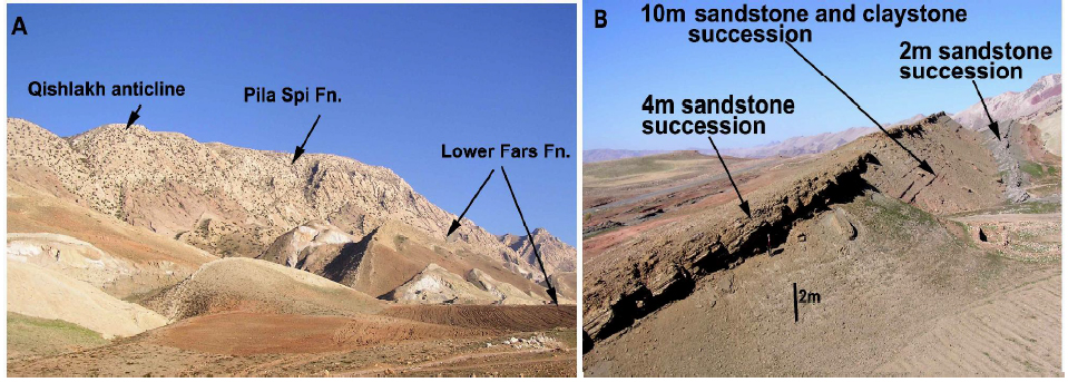 Figure 3: A: Lower Fars Formation outcrops at the southwestern limb of Qishlakh anticline. B: At the southeastern dip slope of Haibat Sultan homocline east of Koya town (directly to the north of Shiwa Shan village) where many evidences of tempestite can be seen in sandstone beds of the great later extent.
 Figure4: Storm dominated shelf (Walker, 1984) used to illustrate the possibility of deposition of tempestite and turbidite by storm in shallow and deep part of the same basin.
FACIES MODEL OF TEMPESTITES
It is difficult to find a complete ideal facies model for tempestites in the Lower Fars Formation but from different outcrop sections, the ideal one can be established (Fig.7). According to Ensiele (2000) the difference between turbidite and tempestites model is that tempestites model contains hummocky cross-stratification. The siliciclastic facies model of tempestites mainly consists of the association of the following facies from base to the top of column of model:
1. Normally graded sandstone facies
This facies consists of graded massive sandstone (occasionally pebbly). The base of this facies consists of storm erosion surface, which may be undulatory or flat. This surface has sole marks and clasts of pebbles (Fig.11C). It is deposited by upper flow regime by rapid events.
 Figure: 5: A: Low angle cross lamination found in the sandstone of Lower Fars Formation at east of Koya town (proximal area). It is possibly represents part of hummocky cross stratification .B: Erosional surface and low angle cross bedding possibly formed by storm generated wave (north of Darbandikhan town, near Chinara Village).
 Figure: 6: A: ripple marks bifurcated found in the fine grain sandstone of Lower Fars Formation directly y to north of Chinar Village (north of Darbandikhan town). B: longitudinal ripple marks in the upper part of the formation at north of Shiwa Shan village (south eastern slope side of Haibat Sultan Homocline).
 Figure7: Different parts of an idea model of tempestite as cited in literature by (Ensiele, 2000).
 Figure8: Two type of Skolithos trace fossil found in the clayey sandstone of Lower Fars Formation at the east of Koyia town (near Shiwa Shan village, east of Koya town).
 Figure 9: Oxidized plant debris found in the coarse sandstone of Lower Fars Formation at south Chinara at north of Darbandikhan town.
2. Hummocky cross-stratified sandstone
It is consist of clean and fine to medium grained sandstone with low angle cross- lamination dipping no more than 15 degrees which is called hummocky cross-stratification (Fig.5A and B). This structure initiated by combined flow of storm wave and storm induced geostrophic current.
3. Parallel laminated sandstone facies:
Located on the hummocky cross-stratified facies and consist of plane laminated fine grained sandstone with possible escape structures which is deposited by laminar upper flow regime (Fig.8).
4. Cross stratified sandstone facies
This facies contain wave ripple mark and current ripple marks showing cross lamination. It is deposited by lower flow regime oscillatory currents due to waning effect of storm (Fig.6).
 Figure: 10: flatiron geomorphologic forms which are developed by stream dissection of competent sandstone and gypsum beds of Lower Fars Formation at southwestern plunge of Qshlakh anticline, southwest of Sulaimani City.
 Figure:11 Sedimentary structures supposed to be formed by storm found in the sandstone succession of the lower part of the formation. A: flaser bedding, B: flute cast, C: Graded bedding, D: Striation mark (tool marks)
 Figure12: Stratigraphic column of Lower Fars formation for the studied area at basin periphery
CONCLUSIONS
The following conclusions can be drawn:
1-Many sedimentary structures are found in shallow water environments in the middle part of the Lower Fars Formation in basin periphery.
2-The structures are revealed reworking of the sediments by storms during accumulation of the Lower Fars Formation. The reworked sediments are deposited as tempestite.
3-The recoded sedimentary structures are: hummocky- cross stratification, longitudinal ripple marks, plant debris, tool mark and flaser bedding.
4- The environment of the formation is changed from previous calm evaporitic lagoon to storm affected evaporitic foreland basin with fresh water influx from source area to basin periphery.
REFERENCES
Ameen B.M., 2006. Geological relation between clastic,evaporite and limestone layers in Fatha (Lower Fars Formation, NE-Iraq. Iraqi.Geological.Jour.(in press).
Ainsworth, R.B. and Crowley, S. F. 1994. Wave–dominated near shore sedimentation and “forced” regression: post abandoned facies, Great Limestone Cyclothem, Stainmore, UK. Journal of the Geological Society, London, vol.151, pp.681-695.
Bhattacharya, J. P. and Willis, B.J. 2001. Low stands Delta in the Frontier Formation, Powder River Basin, Wyoming: Implications for sequence stratigraphic Models. AAPG Bulletin, Vol. 85. No. 2. Pp.261-294.
Buday, T. C, 1980. In: Regional Geology of Iraq: vol. 1, Stratigraphy, I.I.M Kassab and S. Z. Jassim (Eds) D. G. Geol. Surv. Min. Invest. Publ. 445p.
Buday, T. and Jassim, S.Z. 1987. The Regional geology of Iraq: Tectonics Magmatism and Metamorphism. I.I. Kassab and M.J. Abbas (Eds), Baghdad, 445 p.
Bellen, R. C. Van, Dunnington, H. V., Wetzel, R. and Morton, D., 1959. Lexique Stratigraphique, Interntional. Asie, Iraq, vol. 3c. 10a, 333 p.
Dunnington, H. V. 1958. Generation, migration and dissipation of oil in Northern Iraq. Arabian Gulf, Geology and productivity. AAPG Foreign Reprint Series No. 2.
Einsele, G. 1998. Event Stratigraphy: Recognition and interpretation of Sedimentary Even Horizons, in: Doyle, P. and Bennett, M. R. (editors). Unlocking the Stratigraphical Record, John Wily & Son, New York, and p.532.
Einsele, G. 2000. Sedimentary Basin: Evolution, Facies and Sediment Budget. 2nd ed.
Springer, 792p.
Goldring, R. 1999. Field Paleontology. 2nd edition, Longman,191.
Jassim, S.Z. and Goff, J.C.2006. Geology of Iraq. Published by Dolin, Prague and Moravian Museun, Berno. 341p.
Karim, K.H.2006. Possible effect of storm on sediments of Upper Cretaceous Foreland basin: a case study for tempestite in Tanjero Formation, Sulaimanyia area, NE-Iraq. Iraqi Journal of Earth Science, Vo. 7. No 2. pp.1-12.
Karim, K. H., 2004b. Basin analysis of Tanjero Formation in Sulaimaniya area, NE-Iraq. Unpublished Ph.D. thesis, University of Sulaimani University, 135p.
Sissakian, V. K., 2000. Geological map of Iraq. Sheets No.1, Scale 1:1000000, State establishment of geological survey and mining. GEOSURV, Baghdad, Iraq.
Mohseni, H. and Al-Aasm, S. 2004. Tempestite deposits on a storm-influenced carbonate ramp: An example from the Pabdeh Formation (plaleogene), Zagros basin, SW Iran.Journal of Petroleum Geology, Vol.27, No.2.
Pettijohn, F. J. and Potter, P. E., 1964. Atlas and Glossary of Primary Sedimentary Structures. Springer-Verlag, Berlin, New York, p.370, 117 plates.
Tucker, M. E. 1991. Sedimentary Petrology. Blackwell Science Publication Co. 260p.
Smith, G. J. and Jacobi, R. D. 2001. Tectonic and eustatic signal in the sequence stratigraphy of the Upper Devonian CanadaWay Group, New York State, AAP, vol.85, No.2 Pp. 325-360.
Walker, R. G. 1984. Facies Model, 2nd Edition, Geosciences Canada Reprinted Series1, 318p.


