Chronicle (Record) of the Oligocene succession (Kirkuk Group) in Duhok Governorate, Kurdistan Region, North Iraq
Kamal Haji Karim and Briar Ahmad Hama
Accepted for Publication in Journal of Zankoy Sulaimani (JZS) volume 21(1 ) 2019
| Abstract | ||
| The previous studies referred to the Duhok area as a terrestrial uplift during Oligocene while the present study achieved completely different result by recording and mapping about 20-30 meters thick succession of the Oligocene Rocks (Kirkuk Group) for first time. The succession extends for about 20 kilometers inside the High Folded Zone and the previous basin boundary of Oligocene shifted to north for more than 50 kilometers. The succession consists of lagoonal limestone and changes in certain places in the north to patchy reef. Few beds of polymictic and limestone conglomerates intervened the succession. The Middle and Upper Oligocene index fossils are common, the most significant ones are Archias hensoni, Austrotrillina howchini, Praerhapydionina delicata, Peneroplis evolutus, Archias asmariensis, Archias kirkukensis and spirolina austrica. The main facies are coral and red algae boundstone, foraminifera and intraclast packstone to grainstone, pelecypod gastropod bioclast packstone to grainstone. The paleogeography setting (model) of the Oligocene is discussed in detail, compared with the previous model and a new model is drawn | ||
| Key Words: Duhok stratigraphy, Oligocene succession, Oligocene paleogeography, Oligocene tectonics.
|
Introduction
The stratigraphy, paleogeography and paleontology of the Oligocene age intensively seized attentions and studied in Iraq and Iran (as main part of Asmari Formation) due to its content of huge quantity of oil in both countries. The Oligocene carbonate successions (Kirkuk Group) are recorded and described in Iraq by Dunnington (1958 [1]), Bellen et al. (1959) [2], Buday (1980) [3], Jassim and Goff (2006) [4]. These authors divided the group into nine formations that belong to three cycles (Table 1). Dunnington (1958) [1] summarized voluminous oil accumulation in Kirkuk Oil Field housed in Oligocene and Eocene limestones.
Table (1) Formation of the Kirkuk Group (Oligocene succession)
|
Environment |
Back-reef | Reef- Fore reef | Open sea |
| Late Oligocene Fms | Anah limestone | Azkand limestone | Ibrahim formation |
| Middle Oligocene Fms | Bajawan limestone | Baba limestone | Tarjil formation |
| Early Oligocene Fms | Shurau limestone | Sheikh Alas limestone |
Palani formation |
Bellen et al. (1959) [2] pointed out to the separation of the upper and lower boundaries of the cycles by unconformities and breaks. Buday (1980) [3] mentioned many problems of the Oligocene formations related to age and possibility of extending their age into upper Eocene. Baba Shekh (2006) [5], observed two conglomerate beds and fossiliferous limestone between the Pila Spi and Fat’ha formations in Sangaw area and referred to the possibility of the presence of Oligocene rocks in latter area.
Ameen (2009) [6] discussed the expressions of the Oligocene unconformity at different sections at boundary between High and Low Folded Zones in Sulaimani and Arbil areas. Kharajiany (2008) [7] focused on the fossiliferous limestones and recognized Baba, Sheikh Alas, Bajwan, Shurau and Anah formations along both limbs of the Ash Dagh anticline, southeast of Sangaw town, in the Foothill Zone.
Location and geology of the studied area
The studied area is located in Duhok governorate, Kurdistan Region, Northern Iraq where outcrops of the Oligocene rock successions are found for the first time. It has about 50 km of diameter includes the area around Duhok city and its center has latitude and longitude of 36o 51’ 29.37” N, 42o 59’ 24.56” E, respectively.
The studied area consists of many mountains and plains, the size of the former feature increase toward north and the later decrease. The physiographic features coincide exactly with structures of the area whereas the mountains and plains are shaped by anticlines and synclines. The main anticlines are Qush, Duhok, Bekhair, Lalish, Bfrica, Zaweta anticlines (Fig.1). All these anticlines are asymmetrical and field observation deciphers attribution of asymmetry to facies changes by which thickness of carbonate are different from one limb to the other.
The Duhok area is located partly in Low Folded Zone and partly in High Folded Zone (Buday, 1980 [3]; Jassim and Goff, 2006) [4] in the Kurdistan Region in Northern Iraq. Globally, the studied area is part of Himalayan-Alpine Orogenic Terrain where, according to Agha et al. (1978) [8], the trend of fold is E-W that follows style of Taurus anticlines. They added that the western part of Bekhair anticline is located in Taurus belt while its eastern part belongs to Zagros with nearly NW-SE trend.
Csontos et al. (2012) [9] discussed linkage of the NW-SE Zagros Mountains Series with the E-W Taurus belt in the studied area. Sissakian and Al-Jibouri (2012) [10] mapped the distribution of the Oligocene in the northern Iraq and showed Duhok area as an area of the non-deposition (Fig.2). Regionally, the studied area occurs among three distinctive and major physiographic terrains of the Middle East. These terrains are Mesopotamian plain, Zagros and Taurus mountain belts. These two belts meet in the studied area and NW-SW trend of the former belt changes to nearly E-W trend of the latter one. According to Al-Hubaiti (2008) [11], Bekhair anticline shifts its axes to the Taurus Range near Zakho town. Al-Moadhen and Al-Obaidi (2015) [12] described a dozen of thrust faults in the area around Duhok city with different transport direction (stress directions) such as south, north northeast and southwest (Fig.3). The field observations of the present study do not support presence of such number of thrust faults in the area.
The asymmetry and different directed vergencies are attributed to possible variation of mechanical stratigraphy of the two limbs of the anticlines due to facies change by which one limb is more competent than other one. The more thickness of carbonate rocks on one limb increase competency and forced the other limb to break up into the fracture zones and attain opposite vergency. Two facts aid this effect of facies change, the first is different geographically directed stresses (transport directions of Al–Moadhen and Al-Obaidi, 2015 [12], fig.3). The second is sudden facies changes of the Oligocene, Pila Spi and Gercus Formations due to their shallow environments of deposition.
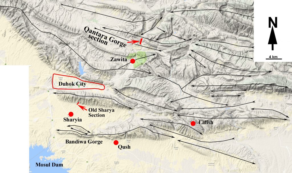 Fig. (1) A topographic map of the studied area (Google terrain image) on which the main anticlines, synclines and two studied section are indicated.
Methodology
The current study about Oligocene succession depends on the fieldwork and microscopic studies. During the fieldwork, the stratigraphic units are differentiated, and two sections are selected for the detail study at the south and northeast of Duhok city (Fig. 1). In the field, the inspection and description of the lithologies of the sections conducted by the naked eyes and hand lens. From the sections the authors collected 50 samples according to the change of the lithology for the lab studies. From the samples, 40 petrographic thin sections are prepared in the laboratories of Department of Geology, University of Sulaimani. The polarized and stereoscopic microscopes are used for differentiation of lithologic constituents and index fossils.
The names and locations of the sections are Old Sharyia and Gali Qantara sections which are located at the latitudes and longitudes of (36° 44′ 40.23” N 43° 02′ 11.62” E), (36° 56′ 38.12” N 43° 09′ 44.46” E), respectively (Fig.2). The first section is sampled from the base while the second sampled from the top due to ease of sampling. These sections are correlated mutually and plotted on a topographic map and the Google Terrain Images. A previous geological map is modified to show the location and distribution of the Oligocene succession.
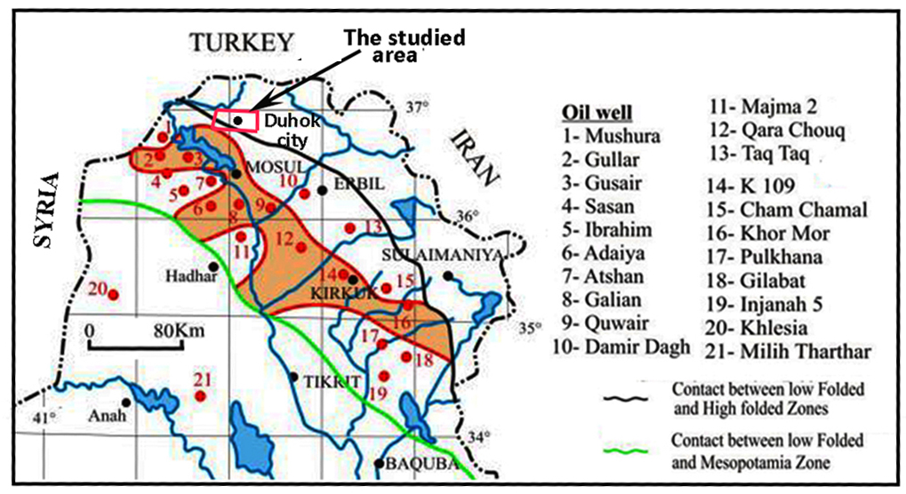 Fig. (2) Distribution of Kirkuk Group (red area) (Sissakian and Al-Jibouri, 2012) [10] on which the studied area is indicated
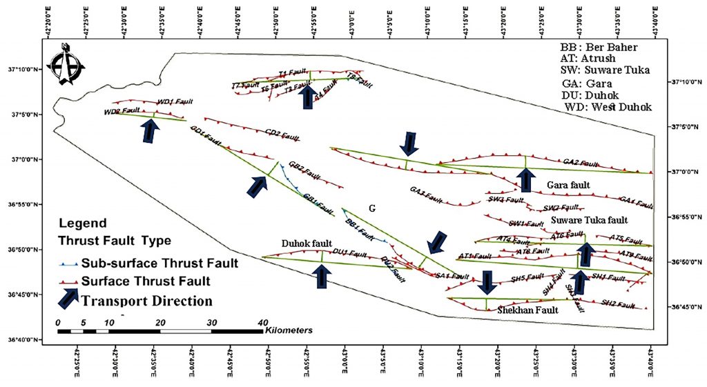 Fig. (3) Ten thrust faults with different vergency and stress directions along the axis of anticlines around Duhok city (Al-Moadhen and Al-Obaidi, 2015) [12].
Result and discussion
Stratigraphy of the area
- Shiranish Formation (Late Campanian-Maastrichtian)
In the studied area, The Shiranish Formation exposes only in the core of Bekhair anticline (with possible Aqra Formation) and it has about 250 meters of thickness which consists of marl and marly limestone.
- Kolosh Formation (Paleocene)
The formation consists of black to grey marl, calcareous sandstone and thin beds of conglomerate. Its thickness reaches about 300 m, this thickness is less than that of type section which according to Bellen et al. (1959) [2], reaches 700 meters. It is exposed between the core and outer arc of Bekhair and Zaweta anticlines (Fig.4). Due to relative softness, the accurate true thickness of the formation is unknown as the deformation my doubles the thickness.
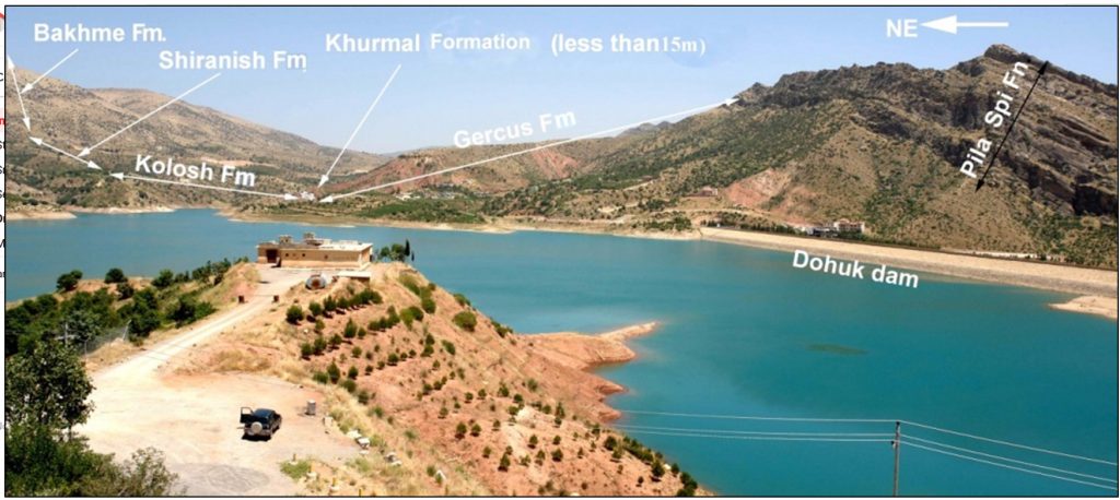 Fig. (4) The eastern part of the Duhok dam valley shows the outcrops of the formations. The Khurmala Formation is less than 10m thick.
- Khurmala Formation (Early Eocene)
The formation consists of thin beds of fossiliferous and detrital limestone which are slightly dolomitized. It has gradational (conformable) boundaries with underlying Kolosh and overlaying Gercus Formations. The Khurmala Formation is less than 10m thick in this area, this reduced thickness may be due to its lateral facies change to the Gercus Formation which concluded by Karim et al. (2018, p.53) [13] in the Darbandikhan area.
4.Gercus Formation
In the Duhok area, the thickness of this formation changes from place to another where the thickness increases toward northeast. Near the Duhok dam, its thickness is more than 200 m and consists of red claystone, sandstone with possible bed of conglomerate (Fig.4). It crops out along outer arc of Bekhair and Zaweta anticlines with Pila Spi Formation. Baziany (2009) [14] found several beds of detrital gypsum which are alternated with detrital bitumen that are reworked from source area. Its upper boundary with the Pila Spi Formation is covered but the lower boundary is conformable with the Khurmala Formation.
5.Pila Spi Formation (Upper Eocene)
In the Duhok area, the formation (with Avanah Formation) has about 100 m of thickness. It consists of well bedded to massive white or grey dolomitic limestone which is occasionally chalky and cavernous with common chert nodules in some intervals. Its upper and lower boundaries with the Oligocene succession and Gercus Formation are not clear due to soil cover but most possible both are unconformable (Fig.6).
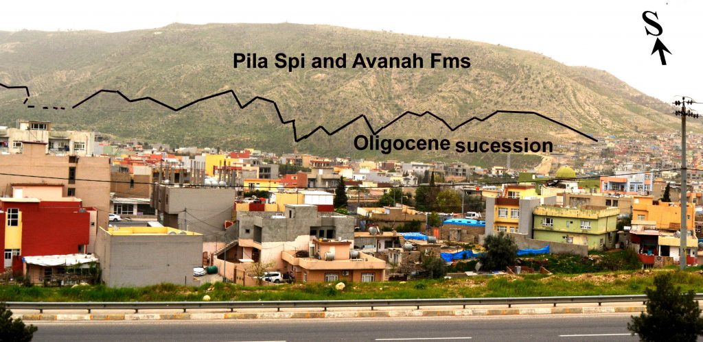 Fig. (5) Kirkuk group overlays Pila Spi Formation directly to the south of Duhok city on Zawa anticline, the photo looks south.
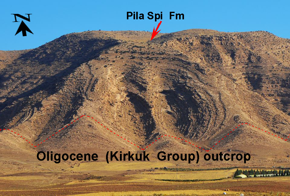 Fig. (6) Two symmetrical oval valleys in the Pila Spi Formation and Kirkuk Group near Sharya village on Zawa (Duhok) Mountain at 3 km south of Duhok city, the photo looks north.
First record of Oligocene succession (Kirkuk Group) in Duhok area
Many authors studied the Duhok area but they did not record the Kirkuk Group, for instance, Buday (1980, fig.7a) [3], Jassim and Goff (2006, fig.7b) [4], Al-Hubaiti (2008) [11], Sissakian and Al-Jibouri (2012, fig.2) [10], Al-Moadhen and Al-Obaidi, (2015) [12]; Al-Azzawi and Al-Sumaidaie (2018) [15]. In the past, the group is recorded in the Low Folded Zone while recently Khanaqa et al. (2009) [16] and Ghafor et al. (2012) [17] extended the deposition of the group into the High Folded Zone in Sulaimani Governorate. They studied lithologically and paleontologically about 30 m thick of Oligocene outcrops at 24 km south of Sulaimani City in the latter zone.
The present study extended the outcrops and basin of Oligocene rocks into the High Folded Zone more behind the previous studies. The extension is about 50km to the northeast and 30km behind boundary between High and Low Folded Zones in Duhok area. Previously the boundary indicated about 20 km to the south of the boundary of the two aforementioned zones (Fig.1 and 6) For proving the occurrence of Oligocene succession, two sections are selected:
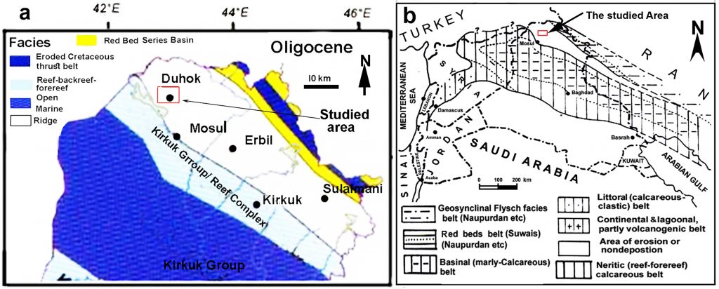 Fig. (7) Distribution of Kirkuk Group, a) Jassim and Goff (2006) [4], b) Buday (1980) [3] on which studied area is indicated
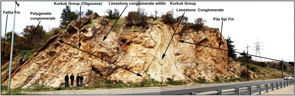 Fig. (8) An Outcrop of the Kirkuk group along a road cut and across the northern side of Gali Qantara Gorge at 19 km to the northeast of Duhok city.
Gali Qantara section
This section is located at the left (northern side) of the paved road between Duhok City and Amedi (Amadyia) town, about 6km to the northeast of Zaweta Village, inside the High Folded Zone. The section exposed across a gorge called “Gali Qantara” where a paved road excavated, and fresh outcrops are exposed across the Qantara ridge that shaped by resistive and competent limestone succession of the Pila Spi and Kirkuk Group (Fig.8). Its thickness is about 30m and located at the latitude and longitude of (36° 56′ 38.12” N; 43° 09′ 44.54” E), respectively.
Old Sharya village section
This section is exposed at the northwestern boundary of the Old Sharya village, 6 km to the south of Duhok city. The section is located on the southern lower limp of the Zawa (Duhok) anticline at the latitude and longitude of (36° 48′ 53.75” N; 42° 59′ 45.68” E) respectively (Fig.9). The thickness of the section is about 20 meters and can be reached via an unpaved road from the New Sharyia village at 20 km to the south of the Duhok City.
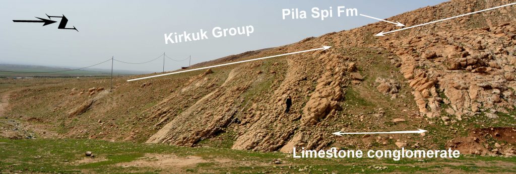 Fig. (9) Kirkuk Group (Oligocene succession) outcrop along southern limb of Zawa (Duhok) anticline, directly to the northwest of Old Sharya village at 5 km south of Duhok town.
Evidence of Oligocene succession outcrops around Duhok City
Previously, geologists not recorded Kirkuk Group in Duhok area and they considered whole time span (about 14 m.y.) of Oligocene as time of uplift, terrestrial erosion and unconformity. We think that one reason for the previous non-recording of the Oligocene succession is low thickness (20-30 meters) in the aforementioned area. Due to the thin thickness, the outcrops are located always in low land along the lower limbs of anticlines and more or less covered by vegetation. Another fact is presence of limestone conglomerates between the overlying and underlying formations whereas these conglomerates are hardly being found in outcrop except along newly excavated road cuts (Fig.8).
There are many indications that prove the occurrence of the Oligocene rocks in Duhok area, the first one is presence of the succession in its proper stratigraphic position between Pila Spi and Lower Fars (Fatha) Formations. The second is presence of splintery pure calcitic limestone that exactly similar to the recently recorded Oligocene in the High Folded Zone at south of Sulaimani City by Khanaqa et al. (2009) [16] and Ghafor et al. (2012) [17]. The third is presences of reefal limestone such as corals and red algae both as erected and encrusting forms (Fig.10 and 11) which are not present in both Fatha (Lower Fars) and Pila Spi formations. The fourth is presence of Middle to Late Oligocene index fossils such as Archia hensoni, Austrotrillina howchini, Praerhapydionina delicata, Peneroplis evolutus (Fig.12), Praerhapydionina delicata, Archias kirkukensis (upper left) and spirolina austrica (Fig.13) in the Qanatra section. In the Old Sharyia section the following index fossils are found: Sivasina egribucakensis, Bigenerina sp, Spirolina cylindracea Haymanella huberi, peneroplis elegans, Sivasina egribucakensis, Haymanella huberi, Coscinospira sivasensis, Indalina piggnati Rupilian (Figs. 14 and 15).
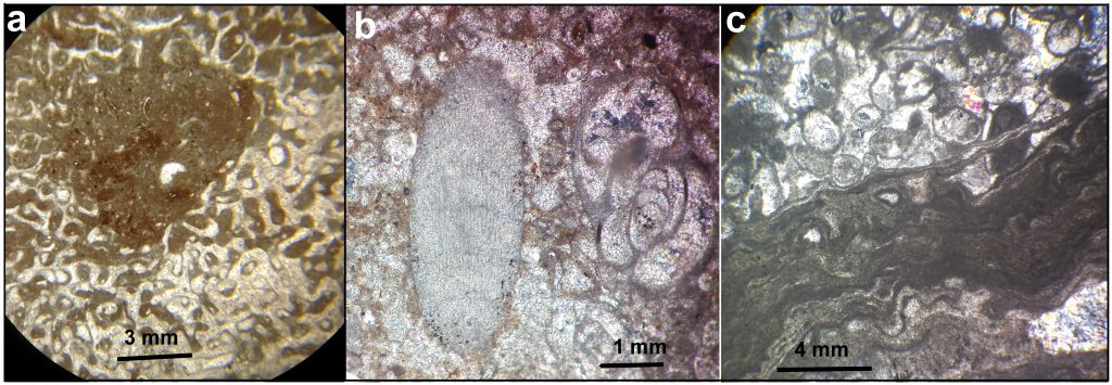 Fig. (10) An encrusting coral (a), erecting red algae colony s.n. G20 normal light, (b) and encrusting red algae, c), Kirkuk Group in Duhok area, Gali Qantara, s. n. G17, normal light.
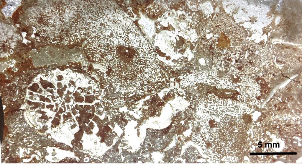 Fig. (11) Erecting coral (lower left) and encrusting coral (rest of the slide) in the Kirkuk Group in Duhok area, Gali Qantaran, s. n. 20, normal light.
The fifth indication is presence of, at least, two conglomerate beds in each section. It is well known that the Oligocene succession in Iraq consists of three cycles and according to Bellen et al. (1959), there are breaks or unconformities between the cycles. In the studied area, the unconformities are represented by outcrops of either limestone conglomerate or orthoconglomerate beds (polygenetic conglomerate) (Figs.16 and 19). These beds are present too inside the Kirkuk Group at the south of Sulaimani city and recorded by Khanaqa et al. (2009) [16]and Ghafor et al. (2014) [17], Kharajiany (2013) [18] and Kharajiany et al. (2014) [19] while Karim et al (2014) [20] has not mentioned any unconformities inside Oligocene succession in Sinjar area.
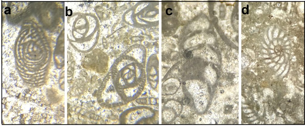 Fig. (12). Oligocene fossils in Kirkuk Group in Duhok area in Gali Qantara section, a) Archias hensoni, s. n. G17, b) Austrotrillina howchini, s.n. G17, c) Praerhapydionina delicata, s.n.G5, c) Peneroplis evolutus.
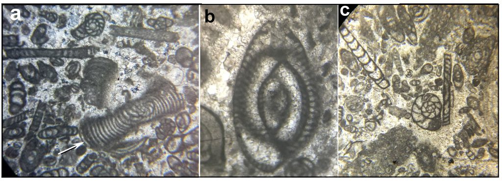 Fig. (13). Oligocene fossils in Kirkuk Group in Duhok area, a) Peneroplis evolutus, b) Archias asmariensis, s.n.G6,ppl c) Archias kirkukensis (upper left) and spirolina austrica. s. no. G8, ppl
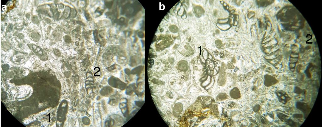 Fig. (14) Index benthonic foraminiferas of the Upper Oligocene of the Old Sharyia section under XP light, X40, a) 1.Sivasina egribucakensis, 2. Bigenerina sp, b) 1. Spirolina cylindracea, 2. Haymanella huberi, s. n. S14.
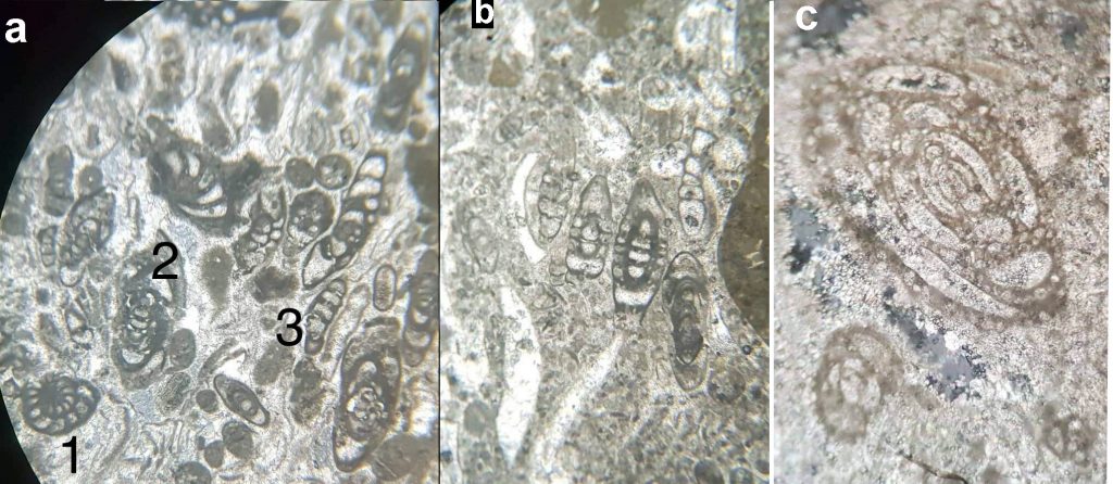 Fig. (15) Index benthonic foraminiferas of the Upper Oligocene of the Old Sharyia section under XP light, X40, a) 1.peneroplis elegans 2.sivasina egribucakensis 3.haymanella huberi, s.no.S18, b) Coscinospira sivasensis, S.no.S18, c) Indalina piggnati Rupilian, s.no. S14.
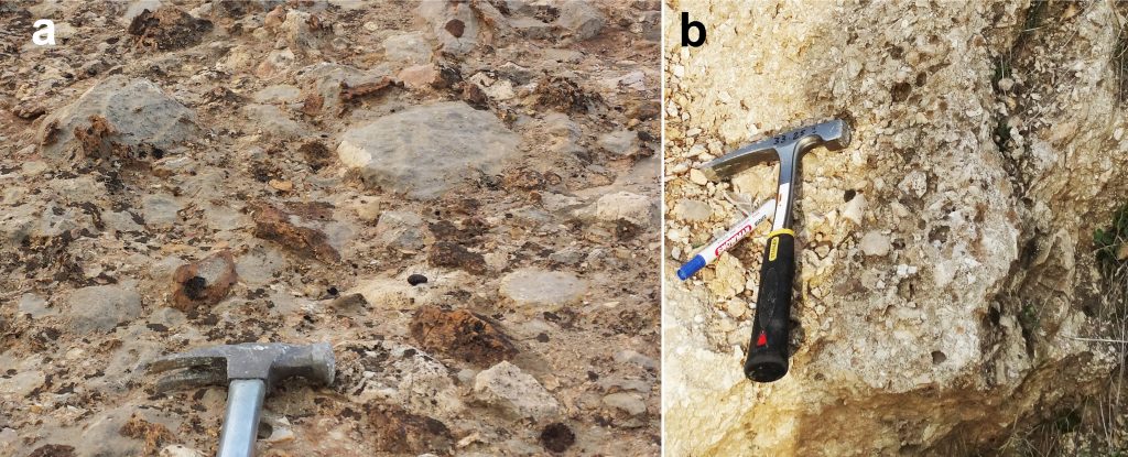 Fig. (16) Two conglomerate beds in the Oligocene succession of the Gali Qantara section, a) Ortho-conglomerate (polygenetic conglomerate) at the top and b) limestone conglomerate at the base of the section.
Paleogeography and Tectonics
Previously, many facies analyses and environment models are drawn by many authors in Kirkuk Oil Fields, south of Sulaimani City, Sinjar area and Iran. However, none of them has detailed on the paleogeography and tectonics during Oligocene of Iraq and the drawn models are simple and general (Fig.17). Previous studies have indicated the Duhok area as the area of uplift and erosion during Oligocene (see Jassim and Goff, 2006, fig.7a [4] and Buday, 1980, fig.7b [3], Al-Hubaiti, 2008 [11]; Sissakian and Al-Jibouri, 2012) [10]. While the present study changed the area to shallow normal marine basin in which the Oligocene and Miocene successions are deposited.
In the present study, for the reconstruction of the paleogeography, the lithology is studied in detail in two sections in addition to reconnaissance works on several other sections. These sections are compared with the lithologies of the precious studies in the aforementioned areas. The detail of the facies is not included in this work since they are studied in detail in Kirkuk and Sulaimani areas (see, Kharajiany, 2008 [7], Karim et al. 2012 [21]).
The facies of the Gali Qantaran (northern section) are those that mostly deposited in a normal marine, shallow and high energy environment such as reef and fore-reef. The recorded facies are bio and lithoclast grainstone (detrital limestone), coral and red algae boundstone (Fig.11), foraminiferal-intraclast grainstone to packstone (Figs. 15a and b), intraclast rudstone (limestone conglomerate) (Fig.16), oolitic grainstone (Fig.19b) and floatstone in addition to orthoconglomerate (extraformational conglomerate) (Fig.16). These facies indicate nearness of the section to basin coast and source area.
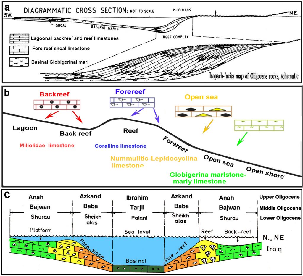 Fig. (17) Previous environmental models of the Kirkuk Group (Oligocene) by a) Dunnington (1958) [1], b) Kharajiany (2013) [18], c) Al-Hashimi, and Amer (1985) [22].
The Old Sharya village section contains mostly those facies that are characterized by relatively Lower energy and deeper water compared to the Qantara section. Its environment belongs to backreef and lagoonal setting, additionally, although the section contains Oligocene fossils (Fig. 14 and 15), but most of the intervals are recrystallized and slightly dolomitic or chalky (Fig. 18c and 19c). Its beds are thinner, and the main recorded facies are mudstone, crystalized chalky limestone, foraminifera packstone, intraclast packstone, pelecypod packstone (Fig.18a) with rare superficial ooid grainstone (Figs..18b and 19b).These facies, in the two sections, are the window through which one can visualize the paleogeography of the Oligocene in the northern Iraq. When one evaluates types of lithologies and facies and compares conglomerate with older ones, the paleogeographic and tectonic timing can be indicated. By mean of the comparison, the paleo-coastal line, energy, paleoslope and nearness of the source area can be uncovered. The stratigraphic and geographic locations in addition to calibers and type of conglomerates have three significances. 1) they are the most southward deposition of coarser and poorer sorted conglomerate than the older ones. No coaster conglomerate is recorded older than the present one in the same geographic and tectonic position in Duhok area (Fig.19a).
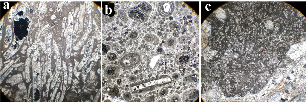 Fig. (18) The main facies of the Sharyia Section, a) pelecypod bioclasts packstone, S.no.15, XP, b) Superficial oolitic Packstone to grainstone, s. no.24, XP, c) a patch of dolomite in pelecypod bioclast packstone, s.no. 13, XP.
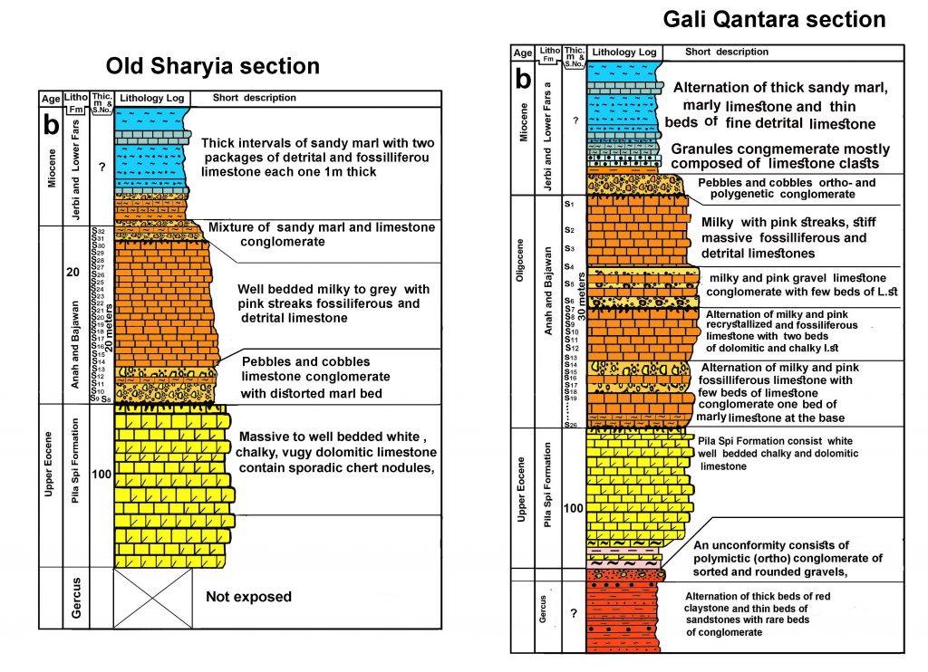 Fig. (19) Stratigraphic columns of the Old Sharyia and Gali Qantara sections in Duhok area
2) More dominance of the limestone conglomerate (monomictic limestone conglomerate) than the polymictic (polylithologic) conglomerate in the sampled sections. 3) The limestones clasts of the conglomerates are mostly belonging to Oligocene succession with some radiolarites clasts. According to the above facts the paleogeography and tectonic setting of the area can be deciphered more accurately than earlier studies. The caliber and type of conglomerate show first uplifting (progressive tectonic stress) has arrived at the studied area during Oligocene.
The paleogeography of the area was a normal marine basin bounded from north and northeast by steep southwestward dipping limestone source area (Fig.19). The proof for this type of source area is the poorly sorting and coarseness of the conglomerates clasts. The growth of reef shows a semi-arid climate with occasional torrential storms on the nearby terrestrial lands (foreland). The turbidity was not too high to inhibit reef growth. In the present study, the top of Gali Qantara contains two beds of red claystone interbedded with orthogonglomerate (Fig.20). Ameen (2009) [6] found red paleosoil (laterite) as representative of Oligocene unconformity in the north of Drabandikhan town and this type of soil is evidence to this type of climate. At the end Oligocene the climate had changed to arid by which gypsum and anhydrite of Fatha (Lower Fars) Formation were deposited.
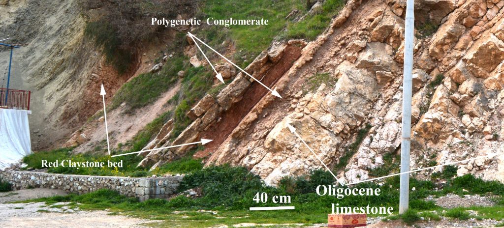 Fig. (20) Top of the Gali Qantran shows two beds of red claystone interbedded with orthoconglomerate.
The limestone clasts indicate that the sediment influx from hinterland (ophiolites and radiolarites in Thrust Zone) was partially isolated from the basin of Oligocene. This isolation most possibly attributed to subsidence of hinterland and generation of local basin. In this connection Karim et al (2018) [18] studied Govanda Formation in the Thrust Zone near the border with Iran in Penjween area and concluded that it deposited in a normal marine basin that developed during Eocene and expanded during Miocene.
The most serious challenge to the tectonic timing (arrival of tectonic stress) at the studied area is what concluded by Numan et al. (1998) [23] who summarized development of two conjugated tectonic syn-sedimentary joints in the Pila Spi Formation (Middle Eocene- Late Eocene) in the Low Folded Zone in Mosul Governorate. They investigated joints in the Ain Safra, Bashiqa and Maqlub anticlines in northern Iraq (at the south of the present studied area). They added that an intermittent synsedimentary horizontal orogenic compression initiated during Middle Eocene at the beginning of deposition of the latter formation. For the prove of Eocene orogenic compression and synsedimentary brittle deformation, they depended on the regional orientation before and after restoration of the two predominant shear joint sets (north-south and northeast-southwest) in the Pila Spi Formation. After the restoration to horizontal (unfolding), they observed similar attitudes of gentle limbs, crestal areas and the steeper limbs.
The present study does not aid tectonic syn-sedimentary joints in the Pila Spi Formation in the Low Folded Zone since tens of articles are published about joint analysis in Low, High and Thrust Zones but none of them proved the above types of joints even in thrust Zone and all attributed them to the post depositional deformations. According to Karim et al. (2009, p.65) [24], the tectonic deformation reached Low Folded Zone during Upper Miocene-Pliocene. Later Ibrahim (2009, p.138) [25] concluded same result by tectonic sand box modeling. Therefore, if the synsedimentary jointing occurred during the bed horizontality, it had not happened during Middle Eocene but during later age, most possibly during Early Pliocene since the layers of the Pila Spi were remained horizontal till later age at the southern part of Low Folded Zone. Another fact that opposes the synsedimentary joints is that Pila Spi Formation is deposited as plastic lime mud whereas impossible to be subjected to brittle deformation (jointing) during sedimentation.
The basin topography consisted of a northern minor reef (patch reef) and a southern main one. The northern one was close to coast and source area from which supplied by flourishing nutrient influx and clear circulated water enriched in CaCO3 (Fig.21). This small reef was surviving along northwest-southeast line stretching few kms inside High Folded Zone parallel to its boundary with Low Folded Zone. This reef was consisted of patch reefs which are small and isolated that grow up from the open bottom of the shelf. They usually survive between coast and barrier reefs. The main reef (southern reef) extended near and parallel to the boundary between Low Folded Zone and Mezopotamain Plain. This reef was barrier reef, opened to open sea, and includes Kirkuk Oil Fields, Qarachugh and Sinjar Mountains. Between the two reefs, the back reef and lagoon environment occurred in which small miliolids, thin shelled pelecypods survived. The paleogeography and presence of the two reefs of the Oligocene is more or less similar to Great Barrier reef which consisted of two reefs (patch and barrier reef) (Fig.22).
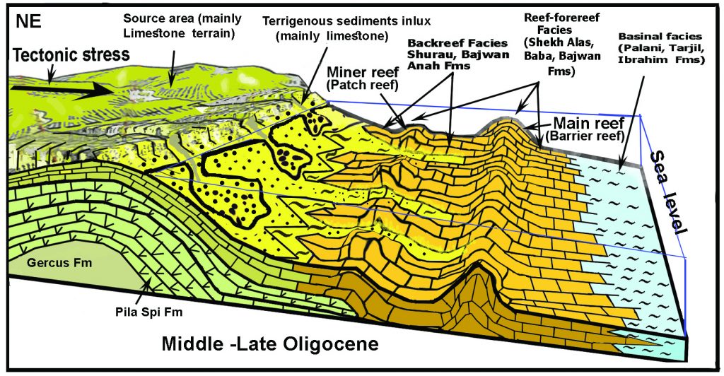 Fig. (21) Kirkuk Group (Oligocene) paleogeographic and environmental model of the present study at Duhok area.
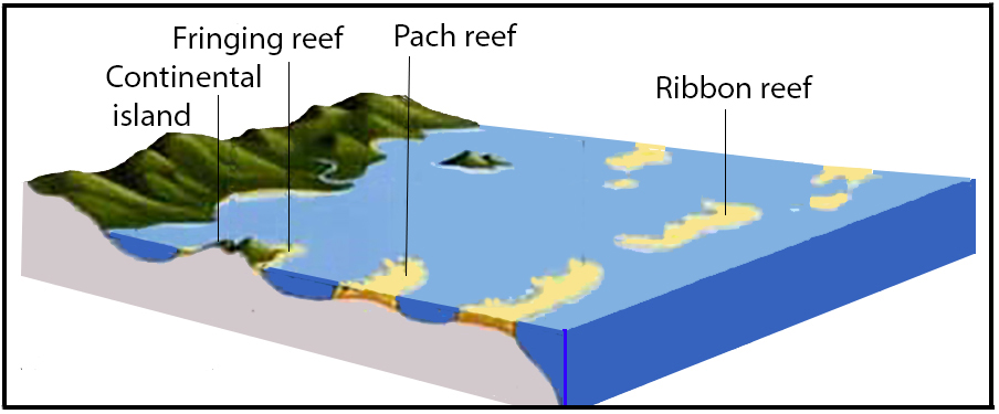 Fig. (22) The present physiography of Great Barrier Reef (South Australia Sea) which consists of two reefs (patch and barrier reef) which are similar to Kirkuk Group during Oligocene (burrowed from https://i.stack.imgur.com/7uY5m.jpg)
Conclusion
The study reached the following conclusions
1-The Oligocene succession (Kirkuk Group) has recorded and proved for first time in Duhok area.
2-The previous uplifted terrestrial land of Duhok area during Oligocene is changed to normal marine basin of platform setting.
3-The Oligocene succession is extended for about 20 kilometers in side High Folded Zone and previous basin boundary of Oligocene shifted to north for more than 50 kilometers.
4- The succession consists mainly of lagoonal limestone and changes in certain places, in the north, to pachy reef with presence of few beds of limestone and polymictic conglomerates.
5-The Middle and Upper Oligocene index fossils are common the most significant ones are Archias hensoni, Austrotrillina howchini, Praerhapydionina delicata, Peneroplis evolutus, Archias asmariensis, Archias kirkukensis and spirolina austrica. ,.Sivasina egribucakensis, Bigenerina sp, Spirolina cylindracea Haymanella huberi, peneroplis elegans, sivasina egribucakensis, haymanella huberi, Coscinospira sivasensis, Indalina piggnati Rupilian,
6- The tectonic deformation first reached the area during Oligocene
References
[1] Dunnington, H.V. (1958) Generation, Migration, Accumulation, and Dissipation of Oil in Northern Iraq. In: Morris A.E.L. (Editor), Arabian Gulf: Geology and Productivity, AAPG Florien Reprint Series, 2: 62-119.
[2] Bellen, R. C., Dunnington, H. V., Wetzel, R. and Morton, D. (1959) Lexique Stratigraphic International. Asie, Fasc., 10a, Iraq, Paris, 333p.
[3] Buday, T. (1980) Regional geology of Iraq, vol. 1, Stratigraphy, edited by Kassab IM, Jassim SZ, GEOSURV. Baghdad, 432 p.
[4] Jassim, S.Z., and Goff, J.C. (2006) Geology of Iraq, Dolin, Prague and Moravian Museum Brno, Czech Republic, 352p.
[5] Baba Shekh, S. M. R. (2006) Hydrogeochemistry of some springs in Sangaw-Chamchamal area. Unpub. M. Sc. Thesis, University of Baghdad, 150p.
[6] Ameen, B.M. (2009) Lithological indicator for the Oligocene unconformity in Iraq. Iraqi Bull. Geol. Min., 5 (1): 25-34.
[7] Kharajiany, S. O. A. (2008) Sedimentary facies of Oligocene rock units in Ashdagh mountain- Sangaw district- Kurdistan region-NE Iraq, Unpublished thesis, College of Science, University of Sulaimani.114p.
[8] Agha, M.T., Numan, N.M.S. and Ma’ala (1978) Field guide for the Geology Duhok and Sinjar area, Fifth Iraqi Geological Congress, Baghdad, 25p.
[9] Csontos. L., Sasvári, Á., Pocsai T, Kósa L, Salae, A. T. and Ali, A. (2012) Structural evolution of the northwestern Zagros, Kurdistan Region, Iraq: Implications on oil migration GeoArabia,17 (2): 81-116.
[10] Sissakian VK and Al-Jibouri B.S.M. (2012) Stratigraphy of the Low Folded Zone Iraqi Bull. Geol. Min., 5: 63-132.
[11] Al-Hubaiti, S.T.M. (2008) Tectonic Style Changes along Bekhair Anticline Axis-Northern Iraq. Unpublished M.Sc. thesis, University of Mosul (in Arabic), 131p.
[12] Al-Moadhen A. A. H. and Al-Obaidi, M. R. S. (2015) thrust fault tectonics in the Duhok Region (High Folded Zone, N Iraq) International Journal of Civil Engineering and Technology (IJCIET), 6 (10): 132-146.
[13] Karim, K. H., Yara, I. M., Kharajiany, S. O., Khanaqa, P. A., Sharbazheri, K. M., Baziany, M. M., Mohammad, Y. O., Mohammed, S. T. (2018) Stratigraphy and Facies analysis of the Govanda Formation from western Zagros, Kurdistan Region, Northeastern Iraq, Iraqi National Journal of Earth Sciences, 18 (2) : 12-35.
[14] Baziany, M. M. Q. (2009) Geology of bedded Gypsum in the Gercus Formation (Early-Middle Eocene) in Duhok area, Kurdistan Region, Northern Iraq, GERMENA III, 5(11): 1-17.
[15] Al-Azzawi, N. K. and Al-Sumaidaie, M. A. H. (2018) Structural and Tectonic Study of Brifka Anticline, Northern Iraq, Iraqi National Journal of Earth Sciences, 18(1): 29-58.
[16] Khanaqa, P.A, Sissakian V.S., Karim, K. H, Karim, S.A. (2009) Lithostratigraphic study of a Late Oligocene-Early Miocene succession, south of Sulaimaniyah, NE-Iraq, Iraqi Bulletin of Geology and mining, 5 (2): 41-57.
[17] Ghafor, I.M., Karim, K.H. and Sissakian, V. (2014) Biostratigraphy of Oligocene succession in the High Folded Zone, Sulaimani, Kurdistan Region, Northeastern Iraq, Arabian Journal of Geosciences, 7(9): 359–361
[18] Kharajiany, S.O. (2013) The Middle Oligocene Rock Strata (Tarjil Formation) in Ashdagh Mountain, Sangaw District, Sulaimani Governorate, Kurdistan Region , NE Iraq, Journal of Zankoy Sulaimani (JZS), 15 (3): 119-132
[19] Kharajiany, S. O. A., Qader, F. M., Hakkari, S. H., Sharbazheri H G. (2014) Oligocene and Miocene Rock Beds in Mamlaha anticline, Chamchamal town, Sulaimani city- Kurdistan Region, Iraq. Journal of Zankoy Sulaimani (JZS), 16 (2): 71-93.
[20] Karim, S.A,, Sissakian. V. K. and Al-Kubaysi, K. N. (2014) Stratigraphy of the Oligocene –Early Miocene exposed formations in Sinjar area, NW Iraq, Iraqi Bulletin of Geology and Mining, 10 (3): 1-28.
[21] Karim, K. H., Khanaqa, P.A., Ismail, K. I. and Sissakian, V. (2012) Facies analysis of the Oligocene succession on the Sharwaldir anticline, NE of the Kalar Town, NE-Iraq. Iraqi Bulletin of Geology and Mining, 8 (2): 1-19.
[22] Al-Hashimi, H. A. J. and Amer, R.M. (1985) Tertiary Microfacies of Iraq. GEOSURV, Baghdad, 56p.
[23] Numan, N. M. S., Hammoudi, R. A. and Chorowicz, J. (1998) Synsedimentary tectonics in the Eocene Pila Spi limestone Formation in Iraq and its Geodynamic implications, J. Africa earth Sci., 27 (1): 141-148.
[24] Karim, K. H, Fatagh, A. I., Azad Ibrahim, A. and Koyi, H. (2009) Historical development of the present day lineaments of the Western Zagros Fold-Thrust Belt: A Case study from Northeastern Iraq, Kurdistan Region 2009. Iraqi Journal of Earth Sciences, 9 (1): 55-70.
[25] Ibrahim, A.O. (2009) Tectonic style and evolution of the NW segment of the Zagros Fold – Thrust Belt, Sulaimani Governorate, Kurdistan Region, NE Iraq, Unpublished Ph.D. Thesis, University of Sulaimani, College of Science, 187p.
مددت الدراسة الحالية النتوءات وحوض صخور أوليجوسين إلى المنطقة المطوية المرتفعة بدرجة أكبر خلف الدراسات السابقة.


