By: Kamal Haji Karim, Polla Azad Khanaqa, Khalid Mahmmud Ismail
published in Journal of Zankoy Sulaimani (JZS) , Vol. 22 (No. 1): 2020
The Zagros Fold Thrust Belt extends for more than 1500 kms from Oman to Turkey and passes through Kurdistan Region, northern Iraq where the studied area is located. The belt is about 200 kilometers wide and the main anticlines axes have the trends of 300°-325° in the area. The present study focused on a local disturbance of the above trends in the Chwarta–Mawat area. The disturbance is expressed by 20-30° of clockwise rotation (toward north) of axes of the local anticlines relative to the non-rotated main trend of Zagros belt. The rotation occurs in the lateral boundary between the Early Cretaceous Balambo Formation (thin bedded limestone and marly limestone) and Qamchuqa Formation (massive limestone and dolomite). These two formations are consisting of incompetent and competent rocks. The reasons for this tectonic disturbance is discussed and analyzed according to the direction of stress in the area and boundary conditions that are associated with the axes rotation. The study attributes the disturbance to lateral facies changes from competent, in the northwest, to incompetent rocks in the southeast. Furthermore, the facies change is associated with presence of massif block (Mawat Massif) which is responsible for transmitting of the northeast Zagros tectonic stress toward southwest direction into areas of anticlines disturbance. Due to this transmission, the rate of the stress propagation, being directed by the massif, is faster in the incompetent units in the southeast which rotates the massif clockwise and forcing the axis of the neighboring anticlines to shift northward about 25 degrees. The massif is a large block (26 km × 8 km) and according to previous studied consists of metamorphic and igneous rocks in addition to conglomerates. The block is located between rotated folds (the local disturbance) and the Main Zagros Thrust. Due to southwest pushing of the massif, the surrounded rocks are folded and aligned parallel to the massif. The rotated folds are localized at the interfaces between the massif and incompetent rocks. The record of this local disturbance is important for analysis of the dynamic evolution of Zagros since the local events can be used for interpretation of regional ones.
1. Introduction
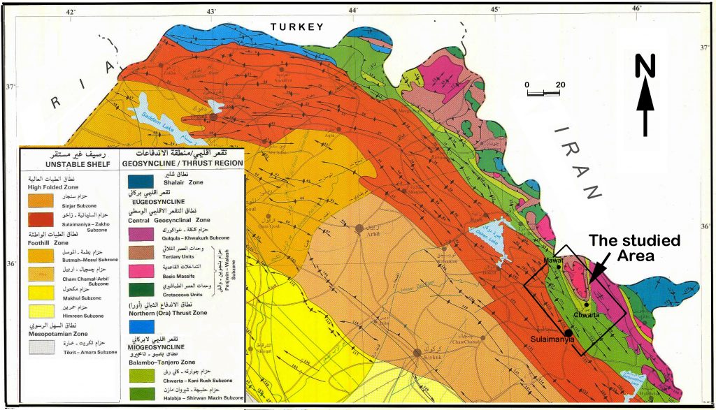
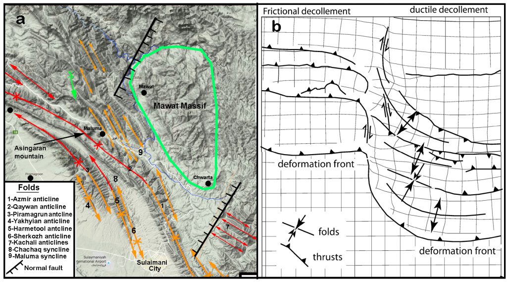
Geographically, the studied area is located at the north and northwest of Sulaimani city in Kurdistan region, northeastern Iraq (Fig.1 and 2). According to tectonic subdivision of Zagros belt in Iran, it is located in both the Simply Folded and Thrust Zones (Sanandij-Sirjan Zone). According to published maps of the belt by Berberian and King, (1981) [1], Alavi (1994) [2], Mc Quarrie (2004) [3] and Emami et al (2010[4]), Zagros belt has width and length of 300 and 2000 kilometers. It covers a part of Middle East between Oman, at the southeast and Turkey, at north and passes through western Iran and northeastern Iraq. It is nearly a straight belt of high mountains but disturbed more or less by Dezoful and Kirkuk embayments (Vergés et al. 2011) [5].
The shortening rate, measured by GPS, of the Zagros belt, in the southwest Iran, is 16 mm/ year and its direction is nearly normal to the trend of the belt while in local place shows obliquity. Hessami et al. (2006) [6]; Vernant and Chery (2006) [7] have indicated matching of the Zagros kinematics to an oblique convergence between Iranian plateau and the Arabian plate at nearly 7 mmyr−1 near Arabian Gulf. They added that the belt is characterized by almost frontal convergence in the SE Zagros and oblique (45◦) in the NW part of the range (near the studied area). They further added that the Main Recent Fault (MRF) bordering the Iranian plateau accommodates all the tangential motion. According to Alipoor et al. (2012) [8], the Main Zagros Recent Fault (strike slip fault) passes at about 37 km to the northwest of the studied area and 20 km to north of the Main Zagros Thrust Fault. The present study aims to discuss the reasons behind local northward shifting of many anticlines axes relative from the main anticlines of the Zagros belt.
1.1. Geology of the area
According to previous studies the northern part of the area is stratigraphically occupied by ophiolite (Late Cretaceous) and Naoperdan Series (Eocene) thrust sheets while the northeastern part is covered by the Qulqula Radiolarian Formation (Early Cretaceous) (Buday 1980[9]; Jassim and Goff, 2006) [10]. The carbonates of the Early and Late Cretaceous age are exposed in the south and southwest of the study area. While the Red Bed Series (Paleocene), Tanjero and Aqra Formation (Maastrichtian) are cropped out in the middle part of the area (studied area).
Tectonically, the studied area represents the northeastern margin of the Arabian Plate (Fig.1 and 2), where the previous Early Cretaceous platform had transformed to a foreland basin during the Late Cretaceous due to thrust loading the platform by radiolarites and ophiolite (Karim, 2004) [11]. The studied area located in the Imbricated Zone of Buday (1980) [9], Buday and Jassim, (1987) [12]. This zone is equivalent to Balambo-Tanjero Zone of Kadhimi eta al. (1996) [13]; Jassim and Goff (2006) [10].
1.2. Method of the study
The study depends on the field mapping for recording the ductile and brittle deformations in the studied area. These deformations are well exposed along the deep valleys sides and high mountains. In the field the attitude of the strata and the trends of main and secondary fold axes are recorded by GPS and compass. In the field, they are photographed and plotted on suitable maps with differentiation of the relevant stratigraphic units by lithology and fossils content with the aids of previous studies. The compass data are plotted on lower hemisphere of equal area stereo net by using the software of Stereonet 9.5 that is prepared by Allmendinger, et al. (2012) [14] and Cardozo and Allmendinger, 2013) [15]. The bedding and fold axes attitudes are fed in to the program according to the option of right hand rule.
2.Result
2.1. Zagros Anticlines pattern
According to Mc Quarrie (2004) [3] The Zagros belt is known for its spectacular fold series, believed to be detached on lower Cambrian salt and resistant limestone anticlines control the characteristic morphology of the region. Alan (1969) [16] has cited many NW-SE folds, which are elongating parallel and formed due to the collision between Arabian and Iranian (Eurasian) plates.
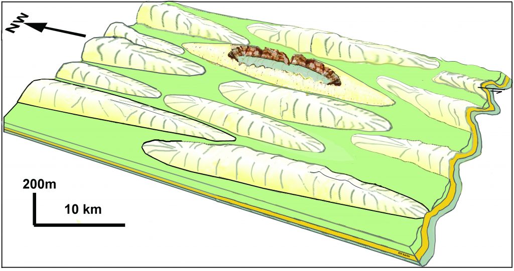
The anticlines are arranged in en echelon (Alavi, 1994) [2] and the belt consists of thousands of large and small anticlines, which are linked transversally and longitudinally by complementary synclines (Fig.3). This pattern, require bifurcating of the synclines and anticlines and thus each anticline is bounded from all sides by synclines.
2.2. Facies change in the studied area
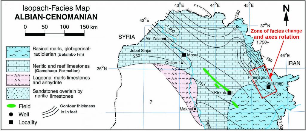
The above-mentioned change of anticline axes is associated with major facies change of the lithology in the studied area and spatially related to the position of the axes changes. Along the zone of axes change, reefal and massive dolomitic limestone facies of Qamchuqa Formation change to pelagic and well bedded marly limestone and limestone of Balambo Formation. These two formations belong to Early Cretaceous age and they were deposited contemporaneously on the Arabian platform and on the basin floor of the Neo-Tethys Ocean respectively. The facies change is documented by Dunnington (1958, [17] fig.4), Buday (1980) [9], Ameen (2008) [18]. In the latter paper, the area of the facies change is indicated and called “Transitional Zone between Qamchuqa and Balambo Formation”. Rheologically, these two formations are classified as soft and stiff facies or lithologes respectively and they deform differently.
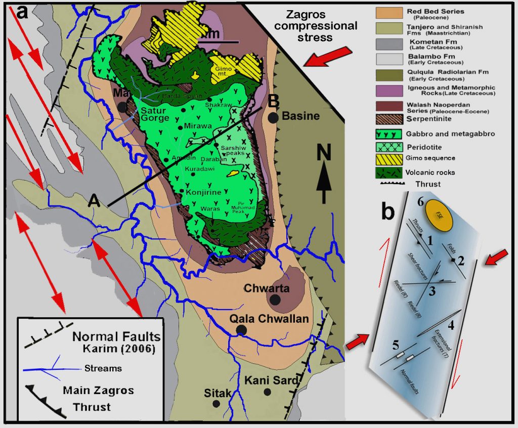
The soft facies (pelagite and hemipelagite of Balambo Formation) deposited in the south and east of the studied area (Fig.4).The soft facies are located between two massive and stiff lithologies of Qamchuqa Formation at the west and Mawat Massif at the east. This massif consists of different rocks such ophiolite (gabbro, peridotite, dunite and volcanic rocks), marble and conglomerate of Red Bed Series (Al-Mehaidi, 1975[19]; Othman and Gloaguen, 2014) [20].
2.3. Northward rotation (shift) of axes of the local anticlines
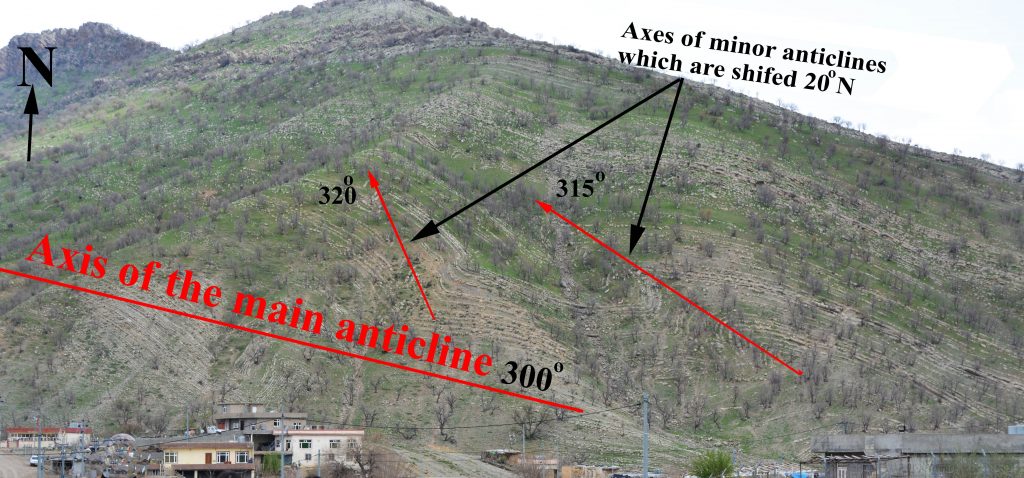
This study has grouped the anticlines into two types, the first is those that their axes have general (common) trend of the Zagros belt that are indicated on the structural map of Al-Kadhimi et al.(1996) [13] and they are called “Zagros Main Anticlines: ZMA” which are shown in red arrows in the figure2. The other type is those that are shifted (rotated) clockwise northward and called “Shifted Anticlines: SA”.
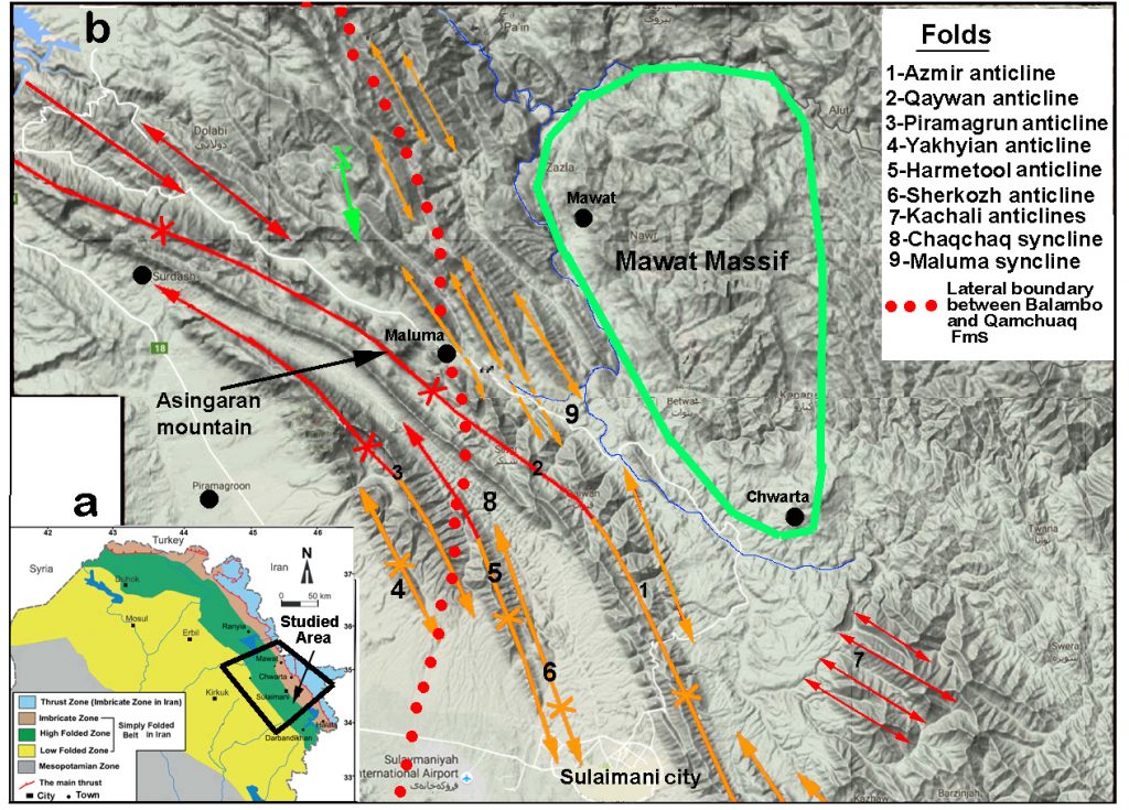
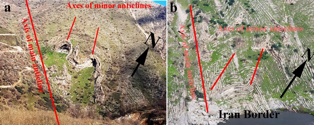
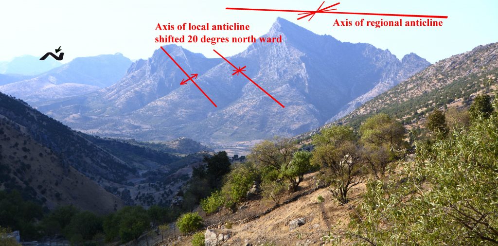
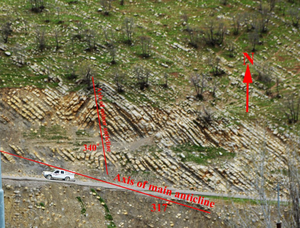
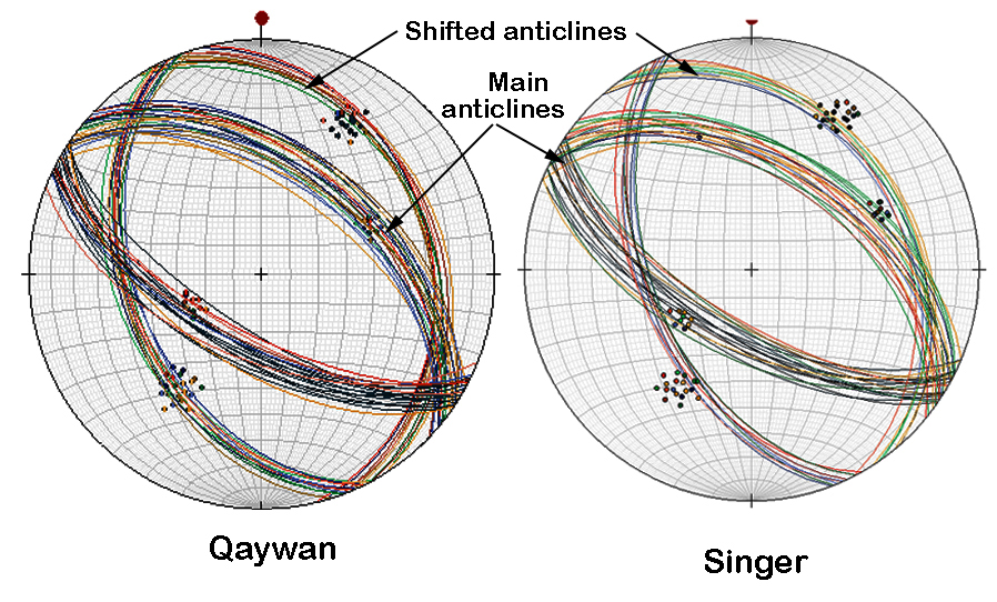
In the whole Zagros belt the common azimuthal trends of the ZMA are 300°-325° degrees, while the mean azimuth, in the studied area is 315° degrees but the SA shift more than 20o northward and change nearly to 340o (Fig.2). The oblique anticlines are relatively small and cutting or obliquely modulating the ZMA. These modulations can be seen clearly around Singer, Qaywan, Gomazal,Garade, Galala, Gapilon and Safra villages (Fig. 6, 7, 8 and 9).
In these areas the SA are lined obliquely to the main anticlines of Zagros trend and they may bifurcated from them with difference of about 20 degrees of axes trends. It is clear that the SA is younger in age than the main ones. This is evident from hosting of the shifted anticlines by main ones and their relation appear as clear cross cutting of the later anticlines by former ones. Another evidence is more exhumation of the main anticlines, as compared to SA ones. The northward rotation is not restricted to independent anticlines but include rotation parts of large anticlines such as southeastern parts of Piramagrun and Azmir anticlines (Fig. 2, no.1 and 6 anticlines).
2.4. Mawat Massif
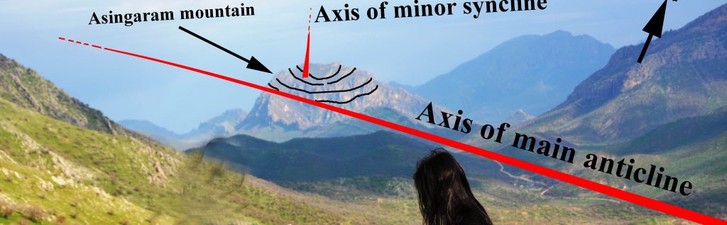
Mawat Massif (Jassim et al. 1983) [21] is composed of mixture of igneous, metamorphic and Meta-volcanic rocks that has 20 and 30 kms of width and length respectively, Jassim and AL-Hassan (1977) [22]; Buda and Al-Hashimi (1977) [23] and Al-Mehaidi (1975) [19]. The latter author studied petrography and origin of the massif under the name of Mawat Nappe and outlined it at north east of Sulaimani city between the upstream of the Lesser Zab River along the Iranian border in the north and the of Chwarta town in the south.
From north and northeast bordered by Qulqula Radiolarian Formation (Zagros Radiolarites) while in the east, southeast, south and southwest surrounded by Cretaceous pelagite and hemipelagite (Balambo, Kometan and Shiranish Formations). The most important geological characteristic of this massif is its competence as compared to the surrounding sedimentary rocks. Another characteristic is its elongation exactly parallel to the present axes of shifted anticline (Fig.5). This parallelism can be seen between the axes of the SA and southwestern boundary of the Mawat massif.
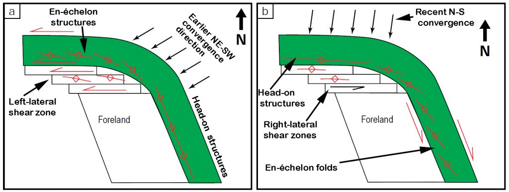
The deformational structures of massif and its surrounding areas are agrees with transpressional deformations that cited and modeled by Milia and Torrente (2000) [24]; Vaughan et al (2012) [25], Yin (2012) [26] (Fig.5b) and Sarkarinejad and Azizi (2008) [27]. In the present study, the whole model is rotated for directional matching of stress direction in the model (red arrow in fig.5b) with main tectonic stress direction of Zagros belt.
After matching, of the stress model with that of Zagros, the model revealed origin of many structures of the studied study. From the figure 5a, the two normal faults indicated by Karim (2006) [28] are nearly coinciding with the two normal faults in the model of transpression deformation (Fig.5b5). The Main Zagros Thrust, anticlines and shear fractures in Mawat area (Buday, 1980[9] and Jassim and Goff, 2006) [10] are matching with those of the model of the figure (5b1, 2, 3 and 5). Even the finite stress ellipsoid (FSE, see fig.5b6) is nearly similar to Mawat Massif in shape and direction of elongation (deformation).
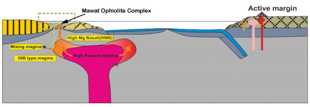
The geological setting of the nape by (Mehaidi, 1975) [19] (Fig. 6) and all the later authors envisaged surficial thrusting of the nappe toward the southwest. Although there are strong attitudinal status between the nape and SA structures, but its thrusting cannot be responsible for the deep deformation and shifting of small anticline. This is due to presence of SA in deep valley (e.g. valley of Safra-Zaron, about 500 m below the level of nappe. Therefore, we think that the Mawat area is not a nape but it has deep root in the area which generates deep shifted structures in the west, southwest and south of its margins (Fig. 2, 5, 7, 8 and 9). In literature, analogous to deep root is discussed in detail by Azizi et al. (2013) [29] who refuse nape setting of the Mawat Ophiolite complex (Mawat Massif) and considered the complex as an intrusion of mantle plume into an extensional tectonic regime on the thinning of the lithosphere of the Arabian passive margin (Fig.12). Therefore, according to the observation of the present study about deep root of the Mawat Massif and that of the latter article, the heat that associated with the massif may affected neighboring rocks and more or less effected the differential deformation by softening the mechanical properties of the stratigraphic units
3. Discussion
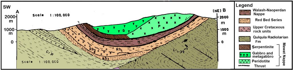
The documentation of the local shifts (changes) of anticline axes is valuable for interpretation of the attitudes of local and regional deformational pattern of Zagros belt. These attitudes are attributed by McQuarrie (2004) [3] to the type of the decollement, where weak, the overlying deformation front propagates farther and faster than the adjacent deformation above a detachment with high friction (Fig.13). The pattern of the anticlines in this latter figure and their rotation toward north is very similar to that of the present study as shown in the figures (2, 6, 7, 8 and 9).The deformation inside Qamchuqa Formation is very similar to friction decollement which mean deformation in massive coherent rocks while ductile decollement is similar to deformation inside Balambo and Sarmord formation in which each thin and relatively soft bed act as easily deformed and perform as ductile medium.
In the model of latter author, there is strike slip fault while according to Karim (2006) [28] and Karim et al. (2009) [30] a normal fault extends from the northwest to the southwest of Mawat Massif and it coincides with normal fault of McQuarrie (2004) [3] (Fig.13 a and b). However, now the authors think that the normal fault not a pure dip slip fault but may be actually oblique slip normal fault to accommodate rotation of the Mawat massif clockwise in the area.
The reasons for this tectonic deformation is discussed and analyzed which are attributed to the stratigraphy architecture of the area including lateral facies change from competent to incompetent. Furthermore, the facies change is associated with presence of massif block (Mawat Massif) at its adjacent north-eastern border. This association is responsible for local anticline axes rotation and transferring of the northeast tectonic stress in privilege condition to the incompetent rocks (Balambo Formation) at the southeast of the studied area. Consequently, the elongation of the Mawat complex aligned nearly parallel to axes of the structures SA (shifted fold axes) (Fig. 5). The deformation اof the studied area was inhomogeneous due to facies inhomogeneity of the studied area at the west and south of Mawat complex. Rayan et al. (2014) [31] summarized the effect of lateral lithologic change on structure in orogenic belt and mentioned that lateral facies changes in the stratigraphy of mountain systems may be important drivers of long-strike variations in structural style.
While the model of McQuarrie (2004) [3] agrees with the present one, the model of Csontos et al. (2012) [32] gives the completely opposite results (Fig.14). In this figure, the trends of the Early Miocene anticlines (older anticlines) in Iraqi Zagros were more northward (about 338o) than the recent ones (younger anticlines) trending 318o (Fig.14a and b). The results of the present study prove that the younger anticlines are more shifted northward than the older ones (Fig.15). Therefore, the present study has significant result since it uncover local disturbance of the structure of the Zagros Fold-Thrust belt in addition to opposing historical alignment of the anticlines in some previous studies.
Fig.(13) Comparison between structures of the Mawat area (a) and structures of the model of Mc Quarrie (2004) [3] (b). It can be see that the two models contain two types of rocks, normal faults, tectonic fronts and rotation of axis of anticlines.
4-Conclusions
1-For the first time local disturbance of axes of local anticlines is found in Zagros of Kurdistan Region which modulated the main axes of anticlines.
2-The disturbance is represented by northward shifting of the minor anticline in the area between Sulaimani city and Mawat town
3- A recording of shifting of minor anticlines in the studied area for about 20 degrees from the regional trend of axes of main anticlines of Zagros Belt.
4-The reason for the shifting is attributed to the presence of Mawat Massif and presence of soft rocks (facies change) along boundary of the massif but transversal fault movements could be another reason for this phenomenon
5-It is expected that the shifted (minor) anticlines are younger than the main ones due to cross cutting relation.
References
[1] Berberian, M, King, GCP (1981) towards a paleogeography and tectonic evolution of Iran. Can. J. Earth Sci. 18: 210-265.
[2] Alavi M (1994) Tectonics of the Zagros orogenic belt of Iran: new data and interpretations, Tectonophysics, 229(3-4): 211-238.
[3] McQuarrie N (2004) Crustal scale geometry of the Zagros fold–thrust belt, Iran, Journal of Structural Geology, 26: 519–535.
[4] Emami, H, Verges, J, Nalpas, T, Gillespie, P, Sharp, I, Karpuz, R, Blanc, EP and Goodarzim, MGH., (2010). Structure of the Mountain Front Flexure along the Anaran anticline in the Pust-e Kuh Arc (NW Zagros, Iran): insights from sand box models. In: P., Leturmy and C., Robin (Eds.). Tectonic and Stratigraphic Evolution of Zagros and Makran during the Mesozoic – Cenozoic. Geol. Soc., Sp. Pub., 330: 155-178.
[5] Vergés J, Saura E, Casciello E, Fernàndez M, Villaseñor A, Jiménez-Munt, I, and García, Castellanos, D (2011) Crustal-scale cross-section across the NW Zagros Belt: implications for the Arabian Margin reconstruction, in: Geodynamic Evolution of the Zagros, edited by: Lacombe, O, Grasemann, B, and Simpson, G, Geological Magazine, Cambridge, UK, 148:739–761.
[6] Hessami K, Nilforoushan, F and Talbot C J (2006) Active deformation within the Zagros Mountains deduced from GPS measurements, Journal of the Geological Society, London, 163: 143–148.
[7] Vernant P and Chery J (2006) Mechanical modeling of oblique convergence in the Zagros, Iran Geophys. J. Int. 165: 991–1002.
[8] Alipoor R Zare M and Ghassemi M R, (2012) Inception of activity and slip rate on the Main Recent Fault of Zagros Mountains, Iran Geomorphology 175–176:86–97.
[9] Buday T (1980) Regional Geology of Iraq: Vol.1, Stratigraphy: I.M Kassab and S. Z. Jassim (Eds) GEOSRVY. Min. Invest. Publ. 445p.
[10] Jassim SZ and Goff JC, (2006) Geology of Iraq, Dolin, Prague, Czech Republic, P.241.
[11]Karim KH (2004). Basin analysis of Tanjero Formation in Sulaimaniya area, NE-Iraq. PhD thesis, University of Sulaimani University, 135p.
[12] Buday T and Jassim SZ (1987) The Regional geology of Iraq: Tectonism Magmatism, and Metamorphism. I.I. Kassab and M.J. Abbas and Jassim, S.Z (Eds), GEOSURV, Baghdad, Iraq, 445 p.
[13] Al-Kadhimi, JAM, Sissekian, V I, Fattah, AS and Deikran, D B (1996): Tectonic Map of Iraq. Series of Geological Maps of Iraq, Scale 1: 1 000 000, sheet NO. 2, 2nd_ed. GEOSURV, Baghdad, Iraq.
[14] Allmendinger, R W, Cardozo, N, and Fisher, D, (2012) Structural geology algorithms: Vectors 399 and tensors in structural geology: Cambridge University Press.
[15] Cardozo, N, and Allmendinger, RW (2013) Spherical projections with OSX Stereonet: 421 Computers & Geosciences, 51: 193-205.
[16] Alan, W., 1969, The crush zone of the Iranian Zagros mountains, and its implications: Geological Magazine, v. 106, p. 385-394.
[17]Dunnington, HV (1958) Generation, Migration, Accumulation, and Dissipation of Oil in Northern Iraq. In: Weeks, LG, Ed, Habitate of Oil, a Symposium, and Association of Petroleum Geologists.
[18] Ameen, BM, (2008) Lithostratigraphy and Sedimentology of Qamchuqa Formation from Kurdistan Region, NE−Iraq. Unpublished Ph D. Thesis. University of Sulaimani, 147p.
[19] Al-Mehaidi, H M (1975) Tertiary Nappe in Mawat Range, N.E Iraq, Jour. Geol. Soc. Iraq 8: 31-44.
[20] Othman A A and Gloaguen R (2014) Improving Lithological Mapping by SVM Classification of Spectral and Morphological Features: The Discovery of a New Chromite Body in the Mawat Ophiolite Complex (Kurdistan, NE Iraq) Remote Sensing 6(8): 6867-6896.
[21]Jassim S. Z, Buda G, Neuzilová M, Suk M (1983) metamorphic development of the Iraqi Zagros Ophiolite Zone, Kryst. Alinikum 16, p. 21-40.
[22] Jassim S Z, Al-Hassan I (1977) Petrography and origin of the Mawat and Penjwin igneous complexes: A comparison J. Geo. Soc. Iraq. Baghdad, Special issue, 169-210.
[23] Buda, G and W Al-Hashimi (1977) Petrology of Mawat Ophiolite Complex, northeast Iraq, Journal of the Geological Society of Iraq, 10: 69-98.
[24] Milia A and Torrente MM (2000) Fold uplift and syn-kinematic stratal architectures in a region of active transtensional tectonics and volcanism, Eastern Tyrrhenian Sea. Bulletin of the Geological Society of America, 112:1531-1542.
[25]Vaughan A PM, Storey C, Kelley S P, Barry T L and Curtis M L (2012) Synkinematic emplacement of Lassiter Coast Intrusive Suite plutons during the Palmer Land Event: evidence for mid-Cretaceous sinistral transpression at the Beaumont Glacier in eastern Palmer Land, Journal of the Geological Society 169 (6): 759-771
[26] Yin A 2012 Structural analysis of the Valles Mariner is fault zone: Possible evidence for large-scale strike-slip faulting on Mars, Lithosphere. 4 (4): 286-330.
[27] Sarkarinejad K, Azizi A (2008) Slip partitioning and inclined dextral transpression along the Zagros Thrust System, Iran. , Journal of Structural Geology, 30:116-136.
[28] Karim, KH (2006) some sedimentary and structural evidence of possible graben in Chuarta-Mawat area, Sulaimanyia area, NE-Iraq. Iraqi,. Jour. Earth Sci., 5: 2: 9-18.
[29]Azizi H , Hadi A, Asahara Y, Mohammad Y O (2013) Geochemistry and geodynamics of the Mawat mafic complex in the Zagros Suture zone, northeast Iraq, Cent. Eur. J. Geosci. 5 (4): 23-537.
[30] Karim, KH, Fatagh, AI, Azad Ibrahim, A and Koy, H (2009) Historical development of the present day lineaments of the Western Zagros Fold-Thrust Belt: A Case study from Northeastern Iraq, Kurdistan Region 2009. Iraqi Journal of Earth Sciences, 9 (1): 55-70.
[31] Ryan, Meghan M, Dowdy, Natalie L, and TIndall, Sarah E (2014) Effects of a lateral facies change on structural patterns in physical models, GSA Annual Meeting in Vancouver, British Columbia Vancouver, British Columbia, Session No. 57.
[32] Csontos L, Sasvári, Á, Pocsai T, Kósa L, Salae, AT and Ali, A (2012) Structural evolution of the northwestern Zagros, Kurdistan Region and Iraq: Implications on oil migration GeoArabia, 17 (2): 81-116.


