Sequence Stratigraphy of Gercus Formation (Middle Eocene)
in Sulaimaniya area, NE-Iraq
Bakhtiar M. Ameen
[email protected]
Department of Geology, College of Science, University of Sulaimani
published in: Iraqi Journal of Earth Science, Vo.6, No.2, p.23-32,2006.
ABSTRACT
The Middle Eocene Red Beds known as typical facies of Gercus Formation in north and northeastern Iraq.In the field they cropout as red succession of claystone, lensoidal sandstones and conglomerates. Tectonically the beds are exposed in the folded area of the Zagros Fold-Thrust belt of northeastern Iraq. The whole formation consists of major low stands system tract within stratigraphic record of Tertiary which belongs to 2nd order sea level change. This major lowstand system tract is divided into two depositional sequences named upper and lower sequences which are modulated within 3rd order sea level change. About 90% of its thickness is deposited in the lower sequence, and 10% in the upper one. The lower sequence bounded by SB1 and SB2 from the bottom to the top respectively. It is comprised of SMST, TST and HST. Only the LST of the upper sequence is represented in the Gercus Formation, while the other systems tracts are possibly included in the carbonate of PilaSpi Formation. The SMST consists of alternation of red claystone and marl which are locate at the top of Khurmala Formation. The TST (middle part of Gercus Formation) is composed of grey marl and laminated marly limestone. The HST consists of alternation of red claystone, laminated sandstone and calcareous shale.
The LST consists of 1-4m of rounded and sorted conglomerate located at the upper part of Gercus Formation. This system tract is underlain by an erosional unconformity. The inferred depositional environment is most possibly braided delta plain which is prevailed by fresh water influx and flooding by marine water. This is shown in the field by mud cracks, marl marine sediments and laminated sandstone which deposited in upper flow regime.
Keywords: Gercus Formation, sequence stratigraphy, molasse facies, systems tract, Khurmala formation, Pila Spi Formation.
التتابع الطباقي لتكوين الجركس(الايوسين الاوسط)في منطقة السليمانية-شمال شرق العراق
الملخص
ان التتابعات الفتاتيةالحمراء لتكوين جركس العائد لفترة الايوسين الاوسط تمثل سحنات نمودجية للمولاس في شمال وشمال شرق العراق .حيث تظهر الطبقات الحمراء في الحقل عتى شكل الحجر الطيني ،الحجر الرملي والكونكلومريت .تكتونيا تظهر الطبقات في منطقة حزام الطيات العالية ومنطقة الزحف لسلسلة الزاكروس في شمال شرق العراق . لقد امكن تميز تتابعين طباقيين في هدا التكوين سميتا بالتتابع الاسفل والاعلى ،ان %90 من السمك الكلي للتكوين قد ترسب فى التتابع الاسفل والمتبقي منه قد ترسب في التتابع الاعلى.يكون الحد الاسفل للتتابع الاسفل ب(SB2) بينما الحد الاعلى ب) SB1 (.يحتوي التتابع السفلي كل من الانظمة المسارية( SMS, TST , HST) بينما تظهر LST) ( العائدة للتتابع الاعلى في الجزء العلوي من تكوين الجركس, اما الانظمة الاخرى فتتواجد في تكوين البلاسبي. ان SMST) ( يتكون من تعاقب الحجر الطيني الاحمر مع المارل فوق الجزء العلوي لتكوين خورمالة .تمثل TST) (الجزء الاوسط من التكوين وتحتوي على المارل الرصاصي مع طبقات رقيقة من الحجر الجيري المارلي، اما ال HST ) (فهو مكون من تعاقب الحجر الطيني الاحمر، الحجر الرملي المترقرق والحجر الجيري الطيني.ان ) LST ( يتكون من طبقة كونكلوميريت ذات سمك( 1 الى 4 ) م والذي يقع في اعلىتكوين جركس تحت الحد الفاصل مع تكوين بلاسبي.ان البيئة الترسيبية افترضت بان تكون سهول دلتاوية ضفائرية غمرت بمياه عذبة مع احتمالية طغيانه بمياه البحرفي بعض الاحيان. وقد تم الاستدلال على تلك البيئة في الحقل من خلال ملاحظة وجود الشقوق الطينية, والترسبات البحرية( المارل) وطبقات رقيقة من الحجر الرملي والتي ترسبت خلال التدفق العالي للجريان.
INTRODUCTION
Gercus Formation is a Middle Eocene unit, which crops out within the boundary between High and Low Folded Zones in Northeastern Iraq (Budy, 1980, Budy and Jassim, 1987). It stretches as narrow northwest-southeast belt near and parallel to this boundary (Fig. 1). The sections are exposed across the scarp slope of elongate homocline which extends from Koya town to the Derbendekhan area. This homocline has many local names like Haibat Sultan, Baranan and Berke Mountain. At the northeastern of this homocline three sections are selected for the study. These sections are: Haibat Sultan, Kalka Smaq and Dara Rash sections which are correlated on the basis of lithology and stratigraphic position (Fig1). The formation mainly consists of alternation of clastic rocks of claystone, sandstone, marl and calcareous shale with occurrence of conglomerate (Bellen et al. 1959).
Al-Rawi, (1980) studied the petrology and sedimentology of Gercus Formation in Shaqlawa and Darbandekhan area. Al-Rawi (1983) studied the origin of red pigment and mentioned that the Gercus Formation in northeastern Iraq consist of a fluvial sequence of associated red and drab beds deposited under an arid to semi-arid climate. Dhannoun H.Y.et.al., (1988) studied the geochemistry of Gercus red beds Formation of northeast Iraq. Dhannoun, (1989) studied the geochemical significance of the distribution of Ni and Co in clayey-siltstone associated with the Gercus Formation of northern Iraq. Al-Qayim and Al-Shaibani 1991, suggested that sediments in Gercus Formation are deposited in a clastic dominated tidal flat. On the basis of main lithological distribution the formation was divided by Ameen (1998) into three parts (lower, middle and upper parts).The aim of this study is to investigate the position and amplitude of sea level change as represented by the lithology and the boundary with other formations.
SEQUENCE STRATIGRAPHY
Sequence stratigraphy is defined as subdivision of sedimentary basin fill into depositional packages bounded by unconformity and their correlative conformities, (Emery and Myers, 1996). In this study the method of Vail et al., 1977 is used for division the rock body of the formation into depostional sequences, this is because the unconformities and correlative conformities can be identified.
The time span and thickness of the part treated in this paper depends on the position of the closest overlying and underlying unconformities and correlative conformities that bound the Gercus Formation in addition to systems tracts (LST, TST, and HST) and the associated sequence boundaries. For clear sequence stratigraphic study of the Gercus Formation it is necessary to study the underlying Sinjar (or Khurmala) and overlaying Pila Spi Formations. Although the boundaries of the above formations are studied previously, no correlation is done as concerned with traditional and sequence stratigraphy.
 Fig. (1) Geological map of northern Iraq (Buday and Jassim, 1987) showing location of the studied section.
LOWER BOUNDARY OF GERCUS FORMATION
The lower boundary of this formation is gradational in Iraq (Buday, 1980), but Bellen et al, 1959) recognize a brake in sedimentation and unconformity, with the underlying Kolosh Formation. Al-Qayim and Salman (1986, p.158) mentioned that the contact seems to be gradational and conformable with Kolosh Formation in Shaqlawa area. The lower contact with Khurmala Formation is gradational (Al-Qayim and Nissan, 1989, Ameen, 1998).Surdashi and Lawa (1993) mentioned that the lower contact of the formation is gradation with Sinjar formation. But Lawa 2004 mentioned a gap (major unconformity) at right side of Dyiala River, between these later formations which spanned about 5m.y. In the studied area the Gercus Formation is overlying Khurmala Formation (or its equivalent Sinjar Formation) and the contact is clearly gradational in all three studied sections. In the field the contact appear as intercalation of thin beds of limestone and brown claystone. The claystone changes gradually to thick beds of red claystone (Gercus Formation). This type of lithologic change is assigned, in this study, as conformity relationship at distal area which changes to minor unconformity up dip the paleoslope near the shoreline. Therefore the contact and the red claystone of lower part of the Gercus Formation are allocated as shelf margin system tract (SMST). In the north and east of Darnabdikhan town both Gercus and Sinjar Formations are mixed as mixed carbonated and siliciclastic successions. These successions can be seen clearly at the left shoulder of Darbandikhan dam (fig.2C).
Boundary between Gercus and Pila Spi Formations
The upper boundary of Gercus Formations is conformable with Pila Spi Formation (Buday, 1980). Conversely, (Shaikh et al.1975, Al-Qayim and Nissan, 1989) observed both unconformable and conformable contact between the two formations. Ameen (1998) has recorded unconformable contact between the two formations in the area between Darbandikhan and Dokan dams. In the present paper this contact is restudied in detail and concluded that it is unconformable, at least, in the most sections (Photo.1 A and B). In the area to the east Darbandikhan dam, there are some indications that change to conformity. This observation is ascertained by Karim (1997) who mentioned gradational contact between the two formations in the Sartak-Bamo Valley.
In the studied area this unconformity is manifested by about one to four meters of polymictic conglomerate which has well sorted and rounded pebbles (photo 6A). The problem with this conglomerate is highly modified by diagenesis. This is manifested by removal of many unstable pebbles by solution with only their cast remained. This removal is attributed to the imperviousness of the underlying rocks (mainly clays). The claystone of Gercus forced the groundwater movement to be concentrated in side the conglomerate at the base of permeable Pila Spi Formation. Therefore, in most case the pebbles are mostly removed in the contact and the conglomerate appears a porous limestone (photo 5A) as can be seen in some locality along Haibat Sultan homocline. It seems that most igneous pebbles are removed due to this solution.
SYSTEMS TRACT OF GERCUS FORMATION
The formation generally deposited as a result of relatively severs tectonic uplift of the northern Iraq especially the area near the Iranian border. The effect of the uplift is modulated more or less by 2nd and 3rd order cycles of sea level changes. The formation as whole can be assumed as level change. These sea level changes can be seen from facies change which arranged in system tracts and depositional systems. The wide-ranged LST of 2nd cycle is divided into two 2nd order cycles which inferred from the ages given by (Buday, 1980 and Bellen et al.1959) which estimated to be about 5millon years (middle Eocene). The lithologic change shows that the two cycles are also modulated by 3rd order cycles. Because of the interference between eustaic sea level change and tectonic uplift and subsidence, the systems tracts are not much clear, due to deposition in nearly similar environments. These factors also forced the system tracts to be not similar in different areas. For example in Sartak Bamo valley, only one system tract is exist which consists only of conglomerate and sandstone that recognized by Karim, (1997) and Lawa (2004). In this area the only one LST can be identified.
 Photo. (2) A: The unconformable contact between Pila Spi and Gercus Formations manifested by two thick beds (6m each bed) of conglomerate which represent LST. B: Same situation exists at Qaradagh area, Sagrma Mountain between the two formations which is represented by 4m pebble conglomerate. C: Mixing (intercalation) of Gercus and Sinjar Formations along left shoulder of Darbandikhan dam.
SHELF MARGIN SYSTEMS TRACT
As mentioned above the lower part of Gercus Formation is deposited during minor sea level change (SMST) (photo 5). The thickness of this systems tract is about 12m and consists of red claystone (photo 4) with interbeds of laminated marly limestone and pure limestone (photo3). This lithology (or facies) without conglomerate and sandstone is evidence for the fact that it deposited as shelf margin system tract. The environment of this systems tract can be considered as delta front and the underlying Khurmala (or Sinjar) Formation as clear water of shelf environment. When the sea level fall is occurred the shelf is not exposed totally. Only part of the shelf is exposed as a delta and the rest remained as delta front depositing red claystone and limestone laminae. In this environment, the limestone lamine are attributed to the short interval of clastic influx impeding. The shelf margin systems tract is underlain by high stand systems tract of Khurmala or Sinjar Formations. These two formations are assigned as HST according to the exposed lithologies and facies cited by Surdashy (1989) Al-Barzinjy, (1990) which are mostly consist of reef and fore reef facies (algal and bioclast limestones) in the east to Koysinjaq town. Moreover Al- Eisa(1983) found planktonic forams in Khurmala Formation at the east of the town ( Shaqlawa area). The relations between carbonate and high stand systems tract are shown, in literature, as following:
Firstly, according to Hanford and Louks, (1994) carbonates or evaporites are mainly deposited during HST and carbonate sedimentation is usually greatest during high stands of sea level because the wide extent of platform flooding. Secondly, according to Sarge (1988), extensive carbonate reef is developed during last Holocene sea rise. Thirdly, carbonate production keeps up with relative sea-level rise, and excess carbonate sand and mud are reworked and deposited in surrounding basins (Doyle and Bennet, 1998).
TRANSGREESSIVE SYSTEMS TRACT
This systems tract comprised the middle part of the formation. It consists of alternation of grey marl (or calcareous shale) with laminated marly limestone. This type of lithology is clearly showing sudden deepening of the basin which is representing transgressive systems tract. The environment of this systems tract can be located at the distal part of delta slope which intermittently supplied by influx of fine clastics. The thickness of this interval is about 15m and called Avanah tongue inside Gercus Formation (Al-Qayim and Nissan, 1989). In so called “Avanah tongue” no fossil was found. No clear maximum flooding surface was found because of shallowness of the environment. But it is possible that the marly limestone beds that located at the top of this system tract may represent equivalent of maximum flooding surface.
 Photo(3):Scarp slop showing lithology and sequence stratigraphy of Haibat Sultan homoclne.
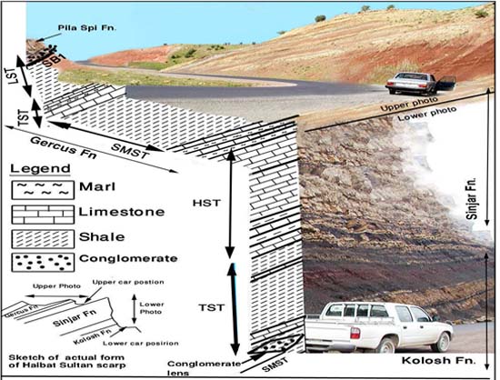 Photo. (4)Lithology and sequence stratigraphy of Gercus Formation at south east of Kalka Smaq village,Dokan area.
HIGHSTAND SYSTEMS TRACT
The deposition of this systems tract occurred during the late part of the eustatic rise, a stillstand, and the early part of a eustatic fall (Van Wagoner et al. 1988). In the field, the further advance into Gercus Formation, through the TST, the marl and limestone change gradually to red claystone and brown sandstone with a thickness more than 70m (photo2). The environment of this systems tract can be assigned as subaqueous and subaerial delta plain which contain mud cracks (photo 6B). The occurrence of mud cracks is resulted from the intermittent covering by flooding manifested laminated sandstone (photo 7A). The distributaries channels on the plain can be seen as lens of sandstone beds (photo 6C).The explanation of Haq(1991) can be accepted for alternation of carbonate and calcareous shale in Gercus formation. He mentioned that during lowstand, siliciclastic is deposited while in highstand carbonate is deposited. This is true when each thick couplet of carbonate –shale is regarded as minor forth or fifth order cycles which suffered from the high and low stand.
LOW STAND SYSTEMS TRACT
The lithology of this systems tract is the coarsest in the succession of the Paleogene in the studied area, as consisted of a bed of polymictic conglomerate about 4m thick. It comprised of gravels which have moderate sorting and roundness (photo 6A). This systems tract is located directly below the Pila Spi Formation. The environment of conglomerate is most possibly consisting of channel of distal braded river which is filled with conglomerate as channel lag deposit. According to Emery and Myers, (1996, p.140) as a result of river rejuvenation; incised valley (which contained a river) commonly contains the coarsest sediment available locally. They added (p.137) if the new river course is steeper than equilibrium river profile, the river would firstly straighten coarse and then incise to form a valley. The shape is lensoidal which is taken the shape in the channel in which it deposited.
 Photo(5)Outcrop section of Dararash valley at the northeastern side of Baranan homoclne.
 Photo. (6) A: The conglomerate between Gercus and Pila Spi Formations. B: Mud crack found in the middle part of Gercus Formation in Haibat Sultan Mountain. C: Sandstone package pinches out rapidly represents channel deposits.
 Photo. (7) A: Parallel laminated sandstone in the middle part of the formation (HST). B: Alternation of calcareous laminated claystone and marly limestone in TST (middle part).
CONCLUSION
The study revealed the following results:
1-The whole rock body of the formation is divided into four systems tract SMST, TST, HST and LST. These systems tracts are deposited during two depositional sequences. The first three systems tract are belongs to Gercus Formation. They called lower depositional sequence while the last one belongs to another depositional sequence which is including Pila Spi Formation.
2- The formation, bounded by SB2 and SB1 from below and the top respectively.
3- The depositional environment is mainly braided delta plain with intermittent influx of marine water.
4- The systems tracts are relatively lithologically similar to each other which attributed to closely related transitional environments of deposition.
REFERENCES
Al-Barzinji, S.J.,1990: Microfacies study of Khurmalla Formation in NE –Iraq
Un.Pub.Ms.C.thesis Unv. Salahadin, 130p.
Al-Eisa,M.I.S.,(1983): Study of the Foraminifera and the depositional environment of
fossils in the Khurmala Formation, Shaqlawa area .Un.Pub.Ms.C.thesis Unv.
Mosul, 94p.
Al-Rawi, Y., 1980: Petrology and sedimentology of the Gercus red bed Formation
(Eocene) NE Iraq. Iraqi J.sci.21 ,1, 1980.
Al-Rawi, Y., 1983: Origin of red color in the Gercus formation (Eocene) NE
Iraq,J.Sedi.Geol. 35,P 177-192.
Al- Surdashy,A.M, 1988, Lithological, facies and environmental study of Sinjar Formation
in selected sections from Sulaimanyia area, Northeast of Iraq; Unpubl., M. Sc.
Thesis, University of Salahaddin.
Al-Shaikh, Z. D., Saleh, S. A., and Abdo, H.F.1975: Contribution to the Geology of
Shqlawa-Harir Area Iraq.jour.Geol.Soc.Sepecial Issue.
Al-Qayim, B. and Salman, L. 1986 : Lithofacies analysis of Paleogene mixed carbonate
area north Iraq.jour.Geol. Soc. vol.19.,No.3.
Al-Qayim, B., and Nisan B. 1989 :Sedimentary facies analysis of A Paleogene mixed
Carbonate-Clastic Sequence,haibat-Sultan ridge, northeast Iraq.jour.Sci. 30, 4.
Al-Qayim, B., and Al-Shaibani S.,. 1991 :A bimodal tidal depositional system of the
Gercus Formation ,Shqlawa area Northeastern Iraq. Salahadin University jour.Sci.
1991.
Ameen, B.M .1998 : Sedimentological Study of Gercus Formation in NE –iraq
Un.Pub.Ms.C.thesis Unv. Baghdad, 103p.
Buday, T. C ,1980: Regional Geology of Iraq: vol. 1, Stratigraphy, I.I.M Kassab and S
.Z. Jassim (Eds) D. G. Geol. Surv. Min. Invest. Publ. 445p.
Buday, T. and Jassim, S.Z. 1987. The Regional geology of Iraq: Tectonism
Magmatism, and Metamorphism. I.I. Kassab and M.J. Abbas (Eds), Baghdad,
445 p.
Bellen, R. C. Van, Dunnington, H. V., Wetzel, R. and Morton, D. 1959.Lexique
Stratigraphique, Interntional. Asie, Iraq, 3c. 10a, 333 p.
Dhanoun H.Y.et.al.,1988; The geochemistry of the Gercus red bed Formation of
Northeastern Iraq Chemical Geology, Elsevier Science Publishes B.V., Amsterdam-
prited in theNetherlands 69,1988 P 87-93.
Dhanoun H.Y.,1989: The geochemical significance of the distribution of Ni and Co in
clayey-siltstone associated with the Gercus Formation (Middle Eocene)of northern
Iraq.Jorn.Geol.Soc.Iraq.1989, 22, 1,PP.140-145.
Doyle P., Bennet M.R., 1998: Unlocking the Stratigraphical record, Advance in modern
stratigraphy ,.Fluvial sedimentation within a sequence stratigraphical frame work, p
336-345.
Emery, D. and Myers, K.1996 : Sequence Stratigraphy. Blackwell Scientific Limited. 297p.
Gallaway, E. W. 1989: Genetic stratigraphic sequences in basin analysis Architecture and
genesis of flooding- surface bounded depositional units. (AAPG), 73, 2, p.125-142.
Hanford and Lauks 1994In loucks, R.G and Sarg, J.F (Rick) eds, carbonate sequence
stratigraphy, (AAPG), Memoir
57, P 3-41.
Karim, K. H. 1997.Stratigraphy of Sartaq-Bamo Area from northeastern Iraq. Iraqi
Geological Journal, 31, 1 .
Sarg J.F., 1988, Sea level changes-An integrated approach Carbonate sequence stratigraphy
P(156-179).
Lawa, F.A.. 2004. Sequence stratigraphic analysis of the middle Paleocene –Middle Eocene
in the Sulaimani District( Kurdistan Region). Unpublished Ph.D. thesis, University of
Sulaimani.
Shaikh et.al.1975 Contribution to the geology of Shaqlawa-Harir area. Journal of the
geological Society of Iraq, Special Issue,pp.55-67 .
Surdashi,A.M.and Lawa,F.A.1993:Stratigraphy,Microfacies and Depositional
Environmentof Sinjar Formation in studied section ,NE. Iraq. Special Issue of
procceding of 2nd scientific conference of University of Salahaddin-Erbil ,PP.77-110.
Vail, P.R., Mitchaum, R.M., Todd, R. G., Widmier, J.M. and Hatleid, W.G.1977. Seismic
stratigraphy and global changes in sea level. In: seismic Stratigraphy –Application to
Hyrocarbon Exploration (ed. by C. E. Payton). Memoir of the American Association
of the Petroleum Geologists, Tulsa, 26, pp49-62.
Van Wagoner , J.C., Posamentier, H.W., Mitchum, R.M., et al., , 1988, An overview of
Vial,r.r.,Sarg.J.F.,Loutit,T.S.,Hardenbol, the fundamentals of sequence Stratigraphy
and key definitions, in Wilgus, C.K., et al., eds., Sea level changes: an integrated approach: SEPM Special Publication 42, p. 39-
45.
Mail, A. D. 2002. Architecture and sequence stratigraphy of Pleistocene fluvial system in
the Malay Basin, based on seismic time –slice analysis. American Association of the
Petroleum Geologists (AAPG) Bulletin. 86. 7.pp1201-1220


