Geology and critical review of the Upper Cretaceous Zagros chalky limestone (Kometan Formation) from Sulaimani Governorate, Northeastern Iraq
Kamal Haji KARIMa (corresponding author) [email protected]
Sherzad Tofeeq AL-BARZINJYa and Polla Azad KHANAQAb
a Department Geology, College of Science, University of Sulaimani, New camp, Siulaimani city, Iraq
b Institution for Strategic Studies and Scientific Research, Qrga, Sulaimani city, Iraq
Published in : BULLETIN OF THE
MİNERAL RESEARCH AND EXPLORATİON
http://bulletin.mta.gov.trBull. Min. Res. Exp. (2018) 157:?-??
ABSTRACT
The chalky limestone (Kometan Formation) is aged Late Turonian–Middle Campanian and cropping out in the High, Imbricate and Thrust Zones of northeastern Iraq, Sulaimani area. It laterally changes to Bekhme and Mushurah formations toward northwest and west Iraq respectively and its reefal equivalents occurs too in subsurface of Central Iraq in the oil fields. Stratigraphically, it is located between Shiranish Formation (Middle-Late Campanian), at the top, and Gulneri Formation (Late Cenomanian-Early Turonian) at its base. It has the thickness of about 40-120 meter and deposited in pelagic realm. All previous studies have defined it as well bedded and fine grain limestone of deep marine facies with concentration of chert nodules and stylolites on or near bedding surfaces. The only recorded fossils are nannofossils, planktonic forms and rare benthonic forams. On the contrary, a most recent study has declined all the above features and changed lithology to massive, homogenous limestone with abundant Thalassinoides trace fossils. It additionally concluded that the bedding surfaces are not true bedding (pseudo-bedding) and formed by stylolization not by deposition. The present study is focusing on update the geology of the Cretaceous chalky limestone and critical review in addition to comparison of all the above ideas and introducing new ones. The features of the Thalassinoides, massiveness and pseudo-bedding of previous authors discussed and their absence confirmed and justified by field and laboratory works. Moreover, the massiveness is refused and well bedding (relatively has thin beds) is proved as an intrinsic characteristic of the formation in all section. The study also shows absence of relation of the chert nodules and chert bedding with traces fossils due to absence of bioturbation, detrital clasts, bioclasts, sorting, lamination and color change. Moreover, the idea of deposition of Kometan Formation in Zagros Foreland basin refused and assumed as deposition of continental margin of Neo-Tethys Sea (or ocean) before ophiolitic obduction and foreland generation.
Key words: chalky limestone, Late Cretaceous, Zagros geology, pseudo-bedding, depositional bedding, Kometan Formation, Thalassinoides,
- Introduction and geological setting
Chalky limestone Kometan (Ilam in Iran) Formation (Late Turonian–Middle Campanian) exposed mainly along the limbs of the anticlines in the High, Imbricate and Thrust Zones of northern Iraq (Fig.1). In Central Iraq, its neritic equivalents (Khasib and Tanuma formations) occur as oil reservoir in the East Baghdad fields (Al-Ameri, 2011). In northern Iraq, it changes laterally to Mushurah Formation toward northwest (Buday, 1980; Jassim and Goff, 2006). Stratigraphically, it is located between Shiranish Formation (Late Campanian) and Gulneri Formation (Late Cenomanian-Early Turonian) at its top and base respectively. According to Dunnington, (1953 in Bellen et al. 1959), the formation consists of thin-bedded globigerinal-oligosteginal limestones and they added that HV Dunnington first defined the formation in 1953. The type locality located in the Naudasht valley 18 km to the north of Ranyia town near Kometan village within Imbricated Zone.
Lithologically, it consists of 40-120 m of fine-grained (pelagic) chalky limestone and shows a crowd of planktonic forams, mainly including Globotrancana and oligostegina species. In many place it contains association of nodules and bands of the chert in addition to high amplitude stylolites. The chert nodules shapes include branched, non-branched, cylindrical or irregular and randomly arranged with 1-7 and 5-25 cm in thickness and length respectively. The area of its exposure is mainly restricted to Sulaimani Governorate (Sulaimanyiah on the map). While toward Arbil and Dohuk governorates, it laterally changes to dolomite and dolomitic limestone of reefal Bekhme Formation (Karim et al. 2012 and Karim, 2013).
In the past, a Portland cement company quarried (used) the formation for cement raw materials near Sulaimani city. This using is due to its minerological constituents, which consist of about 84%, and 7% of microcrystalline calcite and silica respectively, with about 9% clay minerals. In Turkey, the deposition of Turonian- Campanian was continuous too and named Bey Dagları Formation which consisted of neritic and hemipelagic carbonates (Sari and Ozer, 2001; Sari et al, 2004). Lithologically, the formation is more similar to Bekhme Formation than Kometan in the latter country.
In southern Anatolia, the equivalents of Kometan Formation are Derdere and Karababa formations (Late Cenomanian-Early Turonian). The former formation consists of dolomites at the base, dolomitic limestone in the middle, and bioclastic at the top. The latter one composed of about 100 m of dark brown, gray and very fine-grained limestone and bioclastic limestone (Mülayim et al., 2015). In Eastern Iran (on the Kopet-Dogh range) the Upper Cretaceous chalky limestone is Abderaz Formation (Hadavi and Moghaddam, 2011) while in Zagros belt it called Ilam Formation which include both deep and shallow facies (Adabi and Mehmandosti, 2008).
In the earlier studies such as Bellen et al. (1959) and Buday (1980) assigned the boundaries of the formation as unconformable. The same idea is discussed by Lawa et al. (2013) and Lawa and Gharib (2010) which mentioned that Gulneri and Dokan formations are absent between Kometan and Qamchuqa Formations and the unconformity lasted 4.7 million years. Conversely, some recent studies such as Karim et al. (2008), Taha and Karim, (2009), Al-Badrani, et al. (2012) and Karim et al. (2012) conclude gradational boundaries in their studied areas.
Bromley and Ekdale (1983) and Mortimorene et al. (2001) summarize the characteristics of Upper Cretaceous chalks of Europe and when the geology of these chalks compared with Zagros Chalky limestone, they are nearly similar in many aspects. The similarities include age (Cenomanian-Maastrichtian), color, bedding pattern, chert nodule content, presence of beds of glauconite, association of both with marl beds and hardground. However, the differences are softer and cocoliths content of the European chalk instead of planktonic foraminiferas (Fig.2). Another difference is deposition of Europe chalk in shallower and more circulated water.
The present study is aiming to update the geology and objectively review the Zagros chalky limestone (Kometan Formation) and introduce many new ideas about the formation. The given ideas are depending on field, thin section and boundary condition studies of the formation including both lateral and vertical facies (lithological) changes. Additionally, the present study discussed the tectonic setting in detail.
1.1. Location and geomorphology
The studied area is located between the northern latitudes of 35o 09– 20= and 36o 31– 40= and eastern longitudes of 46o 56– 45= and 44o 15– 43= in Sulaimani Governorate, northeastern Iraq (Fig.1). The area includes High, Imbricate and part of Thrust Zone of Buday (1980); Jassim and Goff (2006). It includes towns such as Ranyia, Dokan, Chwarta, Barzinja, Said Sadiq and Halabja towns from northwest to southwest respectively (Fig.1). The main mountains of the area are Karokh, Makok, Kewa Rash, Asos, Kosrat, Azmir, Goizha, Askawta Rash, Kato, Kachali, Pantaw, Greza Bamo and Shinarwe. The highest mountains are Piramagrun and Kura Kazhaw that are about 2300 m high above the sea level. The Kometan Formation mostly cropped out along the sides of these mountains and there are deep and narrow subsequent or consequent valleys between the mountains, which have dendritic drainage pattern. The annual rainfall is more than 650 mm and drained mostly by emepheral streams to the Darbandikhan and Dokan lakes (reservoirs) (Fig.1).
1.2. Materials and methodology
The study of the chalky limestone depends on the fieldwork and microscopic studies. The Kometan Formation is surveyed and inspected lithologically and stratigraphically in the complete studied area by the eyes and hand lens. In the area, six sections are selected and sampled for further laboratory studies (Fig.1). From the sampled specimens, 20 petrographic thin sections prepared for inspection under polarizer and stereoscopic microscopes by which the lithology and its constituents are indicated and photographed. During the fieldwork, the authors studied the boundary condition (all lateral and vertical changes) of the formation in addition to its beds, chert nodules and trace fossils contents. The locations of the sections are plotted on the geological map (Fig.1) and stratigraphic columns of three sections drawn. The field and thin section photos are compared with the previous studies to establish objective argument about origin and mutual relations between features such as chalky limestone, chert nodules, Thalassinoides and stylolites. The previous conclusions (in previous studies) about the materials of the current study are checked and critically analyzed in the field and laboratory.
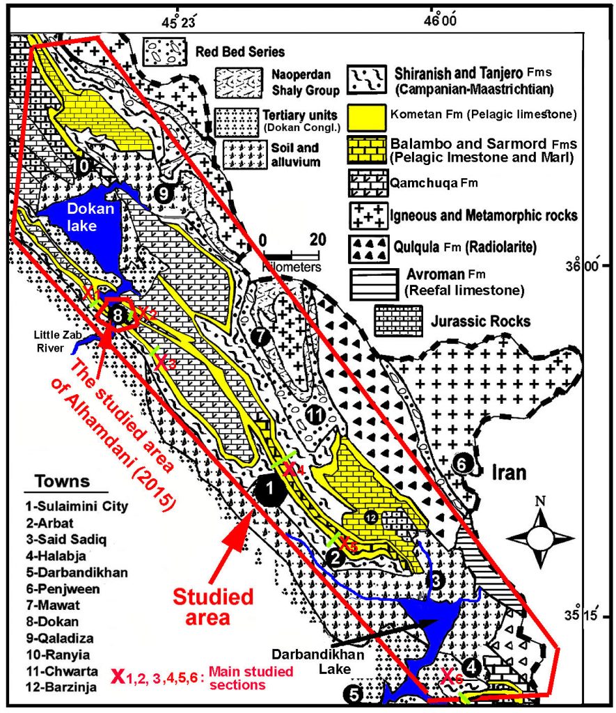 Figure 1- Geological map of the studied area (modified from Sissakian, 2000 and Karim et al., 2011).
- Results
This chapter is concerned with new description and analysis of outcomes in the field and laboratory and compares them with previous studies and then the data critically analyzed with documentation of the newest published ideas about Kometan Formation.
2.1. Well bedded versus massiveness of the chalky limestone (Kometan Formation)
In the literature, all previous studies have indicated that the Kometan Formation is well-bedded succession of pelagic limestone. The most important studies are Bellen et al. (1959), Buday (1980), Jassim and Goff (2006), Karim et al. (2008), Taha (2008), Taha and Karim, (2009) Al-Badrani et al. (2012), Karim et al. (2012), Ghafor et al. (2012), and Karim et al (2013).
Conversely, Alhamdani (2015) concluded massiveness and homogeneity of the formation in Dokan (Dukan) Area (area around Dokan Town, see Fig.1).This article added that bedding planes of the Kometan Formation are pseudo-bedding and formed by pressure solution stylolites in a massive `homogeneous pelagic limestones. This latter study further added that the beds visibility, on weathered outcrops, is deceptive and due to removal of friable clayey stylolite seams by erosion.
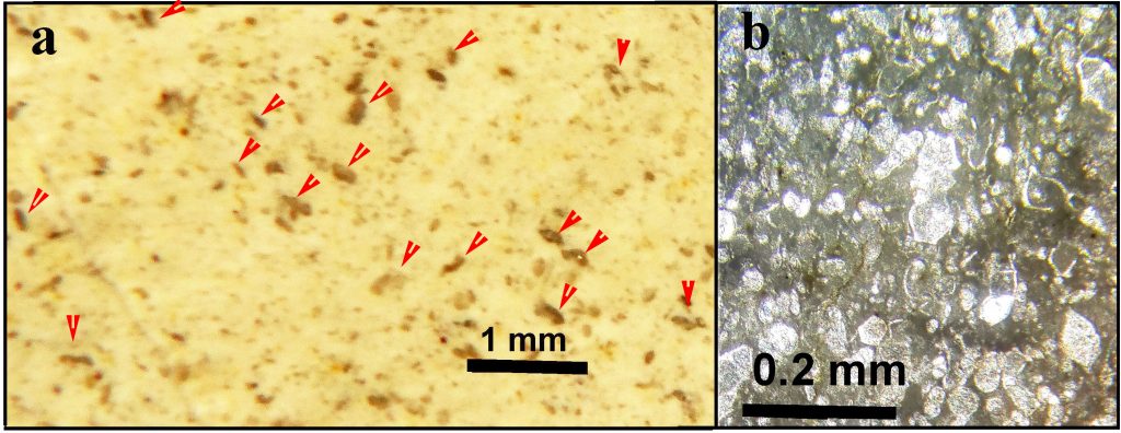 Figure 2- (a) fracture (breakage) surface of the Kometan Formation shows the planktonic foraminiferas (most of them indicated by red arrows) under stereoscope microscope (b) thin section of the formation shows planktonic foraminiferas under polarizing microscope.
The results of the fieldwork in the present study in the entire northeastern Iraq revealed that Kometan Formation is actually well bedded (not massive) and the origin of the layers are sedimentary not diagenesis. The thickness of the sedimentary bedding ranges from 7-25 cm (Fig.3). This true bedding is very clear in all part of studied area which is more than 50 times large (in surface area) than Dokan area where Alhamdani (2015) recorded massiveness and pseudo-bedding properties. In the same area, Al-Barzinjy (2008) showed well-developed and high amplitude stylolites, which are mainly distributed along or around the bedding planes and commonly associated with chert nodules. The latter study mentioned the presence of widespread chert nodules and stylolites in Dokan area and absence in other areas.
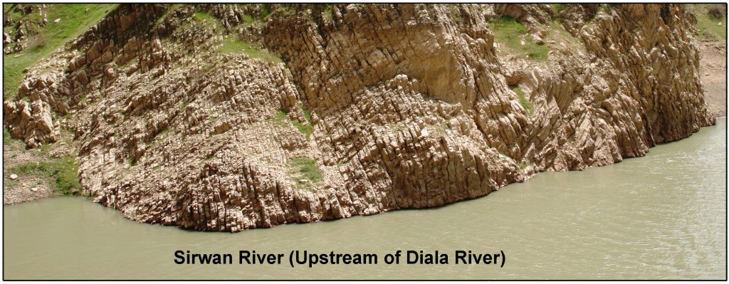 Figure 3- Sedimentation (true) bedding of Kometan Formation in Sirwan valley along upstream of Diala River. These beds are not associated with stylolite and chert nodules.
2.2. True and pseudo-bedding
The non-sedimentary (pseudo) beds and laminations, in Kometan Formation, are mentioned near Said Sadiq town (at 43km to the east of Sulaimani city) by Ghafor et al (2012)(Fig.4). They showed that the laminations have secondary origins which is developed by pressure and flexure slip during folding. The present study confirms the above statement of Ghafor et al. (2012) about presence of the secondary lamination in the Kometan Formation. In Said Sadiq area, the secondary (pseudo) bedding can be distinguished easily from true (depositional) ones which are about 5 times thicker than the secondary lamination (or bedding) (Fig.5a).
The true beds have clear, thick and eroded bedding interface while the secondary ones have faint and thin surfaces (Fig.5a). The true beds, in the figure (5), are observable in bold lines and have nearly same thickness of the beds indicated by Alhamadani (2015) as pseudo-bedding (Fig.5b). The comparison of photo (5a) with photo (5b) shows that they are true ones, while the latter study which assumed them as pseudo-bedding. Unfortunately, the latter study not compared or differentiated between the claimed pseudo- and true-bedding in Dokan area. The true beds must be more clearly expressed than those formed by stylolization.
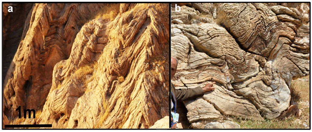 Figure 4- Vertical sections on the Ashbolagh hill near Said Sadiq town, a) shows crenulation and secondary lamination of Kometan Formation, which are modulating (superimposed on) true bedding. (b) Close up view shows crenulation of non-depositional lamination with depositional beds of limestone and cherts (Ghafor et al., 2012).
 Figure 5- a) Kometan Formation near Said Sadiq town shows true (depositional) bedding (red lines) and pseudo beds (green lines). (b) Bedding of Kometan Formation in Dokan area that envisaged being pseudo-bedding by Alhamdani (2015). Comparison with photo (a) indicates that they are true ones which shown by white arrow.
2.3. Relation of chert nodules with Thalassinoides burrows
In Kometan Formation, Al-Barzinjy (2008) and Taha (2008) discussed in detail the origins of stylolites, bedding and chert nodules in the Dokan area. However, Alhamdani (2015) neither discussed nor mentioned these later two works and concluded that chert nodules are controllable chiefly by pre-existing Thalassinoides burrow. This later study further added that the association of silicified burrows (chert nodules) with stylolite veins refers to regressive discontinuity surfaces.
The present study inspected all the outcrops of the Kometan Formation and showed that Thalassinoides burrow and signs of the relation with chert nodules are not observable in all outcrops. Although the Kometan Formation is rich with planktonic foraminifera and nannofossils but any other fossil shells or their pellets that are responsible for claimed Thalassiniodes of Alhamdani (2015) are not observable. Another observation, under hand lens and microscope, is absence colors or lithologic changes, dolomitization, or sorting of the sediment, around the claimed Thalassinoides or chert nodules. Giannetti, et al. (2007) mentioned that the organisms that dwell in Thalassinoides traces are belonging to crustaceans, fish and worms genera. If these traces are true in the formation, they must associated with, at least, more than one of these structures which are mentioned by many authors such as (Kennedy, 1967, Fig.6) McCal (1982), Pak and Pemberton (2003) and Myrow (1995).
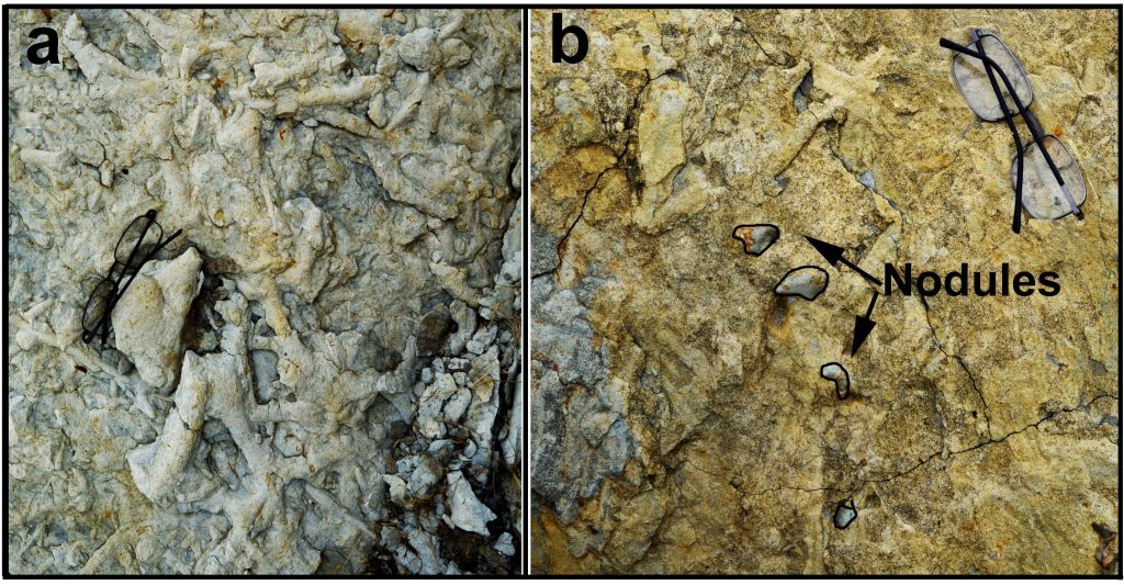
In the studied area and in the upper part of Kometan Formation (directly below Shiranish Formation) there are Thalassinoides and planolite traces, which are associated with the lithologic and color changes (Fig.7) and pelecypod shells. In the figure (7a), the traces have cross cutting relation and they have not silicified to chert nodules and not similar in shape and size to chert nodule in the formation. With the traces, there are chert nodules too but they have not relation with the traces (Fig.7b). Karim et al. (2001) studied these traces and they found hard ground and Glossifungite ichnofacies at the contact between the latter two formations.
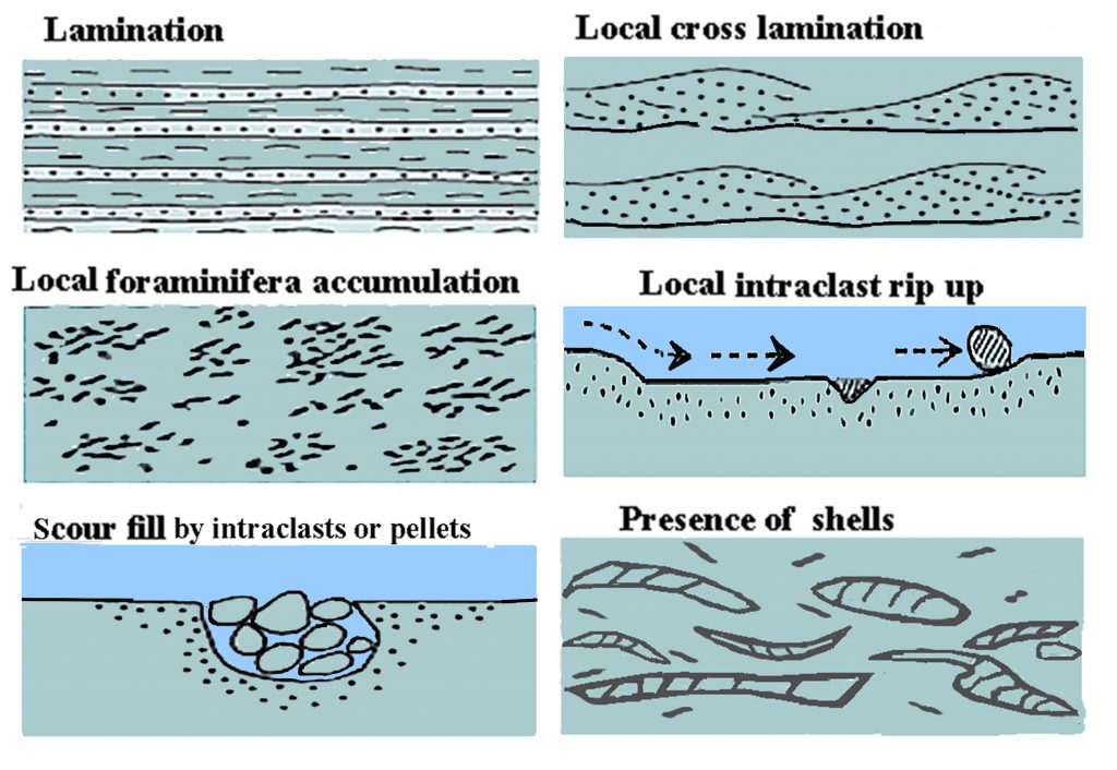 Figure 6- At least one of these structures must be associated with chert nodule (supposed to be Thalassinoides) but non of them are recorded in the present study (drawn from description of Kennedy, 1967).
Figure 7- Trace fossils (possibly planolite or Thalassinoides) in the contact between Kometan and Shiranish Formation in Dokan area. It is clear that neither they silicified nor related to chert nodules. Scale: the glass is 12cm long.
- Discussion
3.1. Problem of the association of the pseudo-bedding, Thalassinoides and chert nodules
The massiveness and homogeneity of Kometan Formation as stated by Alhamdani (2015) are problematic when one reviews literature of the formation. This is due to nine facts, the first is according to Walness (1979) high amplitude stylolites (such as those of Kometan Formation) not formed in homogenous (clean) limestone but non-seam solution occurs. Arther et al. (1986) described North American and European Upper Cretaceous pelagic carbonate sequences as rhythmic bedding. They added that such bedding rhythms could result from climatic cycles that are linked to variations in the Earth’s orbital characteristics (Milankovich cycles). Therefore, the Kometan formation is not homogenous and contains interbed materials, which act as discontinuities for solution circulation that are necessary for chert nodule nucleation and stylolites generation.
The second is establishment of a relation of Thalassinoides with canyon margin in Dokan area by Alhamdani (2015). The critique on this point is neither present study nor Alhamdani (2015) or any other studies proved occurrence canyon margins in Dokan area. In the formation, the present authors did not find evidences of the canyon, these evidences are such as calci-and siliciclastic turbidites, extensive bioturbation by macrobenthos, mega breccia and coarse detrital limestone. Instead, the Formation contains only planktonic foraminifera and nannofossils while it barren of signs of current actives. Moreover, in the formation, no one has recorded color change, clastic sediments, fecal pellet and shell accumulation, effect of current (lamination, cross bedding or sign of reworking such as intraclast and bioclasts sediments). Stevens et al. (2014) referred to these characteristics of sediments in canyon margin setting and in Upper Cretaceous chalks of England by Kennedy (1967). In the current study, the thin section and hand lens inspections revealed very poorness in benthonic foraminifera and above structures are not observable. Therefore, the mentioned canyon margin by Alhamdani (2015) is not supportable by the present study.
The third fact is the problem of the presence of more than 40 horizons rich in chert nodules in a succession of massive limestone about 100 meters thick (as seen from part of the section in the fig.8A of Alhamadani, 2015). If these horizons are Thalassinoides, they are actually evidence of true beds which separated by thin marl interbed. The most remarkable result of Alhamdani (2015) is record of the repeated Thalassinoides horizons and omission surfaces in Dokan area, if these repetitions are true, they indicate true bedding because repetitions of traces horizons and occurrence of omission surfaces are good indications of true bedding which are burrowed during changes of rate of sedimentation and sea level.
It is possible that the marl has compacted and dewatered during early diagenesis and supplied CaCO3 ions for early cementation and lithification of a part of limestone layers that are directly adjacent to the bedding surfaces. Due to this process, the high amplitude stylolization and chert nodules have developed mostly along and near to the interbed horizon in the limestone beds due to their early cementation. Field study shows that the source of silica is closely related to the development of the stylolites since, in many cases, the chert nodules are trailing the line of stylolite not bedding surface (bedding plane) (Fig.9). In the same cases, it appears that nodules have mostly the oval shape and resemble river gravel and granules not Thalassinoides. In Kometan Formation, the marl interbed increase in thickness toward its boundary with Shiranish Formation and in the contact, the thickness of the marl and limestone become nearly equal (Fig.8).
This lithological change and equality of thickness between the two formations is clear evidence for true bedding of Kometan Formation which is shown in several localities by Karim et al. (2008) (Fig.8). If the layers, in Shiranish Formation, are depositional (true) bedding, then those of the Kometan must be the same also. The same thing is true for Gulneri Formation, which is underlying Kometan Formation. The same type of bedding of Kometan Formation continuously passes down and upward to Gulneri and Shiranish Formations respectively.
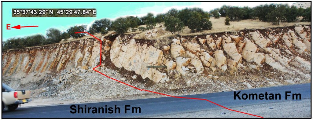 Figure 8- Gradational boundary between Kometan and Shiranish Formation on northeastern limb of Azmir anticline, northeast of Sulaimani city shows alternation of well-bedded limestone and marl of the two formations.
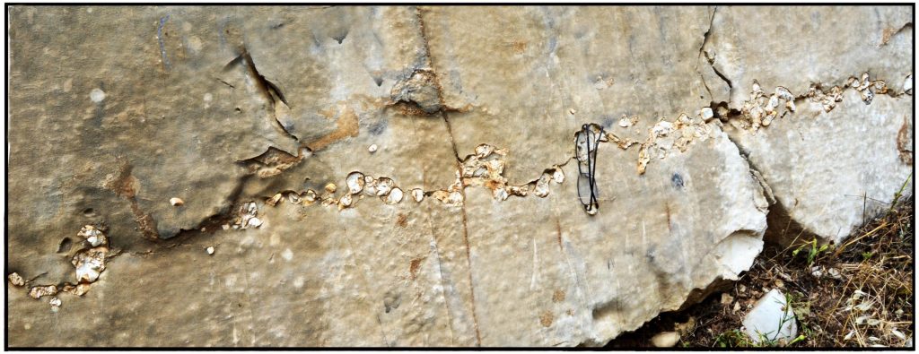 Figure 9- spherical nodules are trailing the stylolite line along a vertical of a bed of Kometan Formation at 2 km southwest of Dokan town.
The fourth critique is that Alhamdani (2015) not used thin section to prove if the growth of the chert nodules is displacive or replacive and only assumed, without evidence, that they are replacing Thalassinoides traces. Conversely, thin section study by Al-Barzinjy (2008) showed clearly that the nodules developed by both replacement and displacement during deep burial. The displacement occurred by force of crystallization of silica and the sources of silica are well documented by the later author.
The fifth criticism against the massiveness of Kometan Formation is presence of bedding plane even in massive limestone succession. However, and unfortunately, Alhamdani (2015) has not differentiated between the true and false beds in the Dokan area. In the latter area, all bedding surfaces (or interbeds) are similar in term of thickness and type of expression. The similarity is evidence for depositional origin of the beds because their interbed are thicker and better expressed in outcrop, which is observable near Said Sad town (Fig.5a and b). The sixth point is that in most areas of the northern Iraq the Kometan bedding pattern is similar and not associated with high amplitude stylolite or chert nodules, only in Dokan area associated with the stylolite. Therefore, the well bedding (relatively thin bedding) of the Kometan Formation is not requiring presence of stylolite and occur in all areas of northeastern Iraq (Fig. 3 and 9).
The seventh point is closeness of all traces to each other on bedding surfaces (or in interbeds) and their shape and size are very different. If the traces belong to crustaceans as cited by the latter study, they must have nearly same shape (oval, elongate, or irregular) and size (the size of granule or cobble) (Fig.8, 9 and 10). The comparison of these figures with (7) shows the actual Thalassinoides traces have nearly similar sizes and shape that located at the top of Kometan Formation. The shapes and size of chert nodules are highly variable in the formation, which are thinning or thickening suddenly and they coexist together (Fig.10 and 11). Thin section study in the present study and other studies of the present authors and others have not recorded fecal pellets and bioclasts. Why do all observed traces, (chert nodules) are not associated with fecal pellets? The answer to this question is that the nodules are not relatable to Thalassinoides in Kometan Formation.
In Europe Sieveking and Hart (2011) has collected many research articles in a book in which the relations between of chert nodules and Thalassinoides are documented. Some of these articles mentioned that the chert nodules are replacement of latter traces. The authors such as Bromely (1967); Bromley and Ekdale (1984) found many evidence of relation between the latter nodules and traces. The evidences are such as nodule digitation, gradation from pure to partially silicified traces and lamellae of spreites in addition to spires around nodules and Thalassinoides activities boxworks.
In chalky limestone of Zagros (Kometan Formation), the authors have not found above features since the shapes and external sculpture of the European chert are different from ones of the present study. Moreover than that the present ones are associated with stylolites and in literature Wangen (2010, p.369) discussed the silica concentration (development of chert nodules) by stylolization due to increase of local silica concentration.
The eighth criticism is presence of chert beds and lamination inside the Kometan Formation in many places (Fig.12). These sedimentary structures are visible clearly around Sharazoor plain where Al-Khafaf, (2014) has well studied the formation. These beds have thickness of 3-7 cm and continuous for ten of meters. The color of bedded chert is back or dark brown and not showing signs of nodules content (Fig.12). Therefore, the attributions of the chert nodules to replacement of Thalassinoides are disagreeing with bedded chert and indicate that chert, as nodules or beds, are a property of Kometan Formation and has not related to the Thalassinoides.
The ninth issue is widely using of Kometan Formation for building stone inside Sulaimani city. The quarries were usable for more than 50 years (called Sherkozh quarries) and located directly to the northwest of city in the Chachaq valley. In the city and the quarries, vast fractured and exposed surfaces are available for accurate study. The critique is on these surfaces, neither trace fossils nor high amplitude stylolites are observable and instead, randomly distributed pyrite nodules are common but they are unrelated to bedding planes or Thalassionides (Fig.13). The inter-beds clayey or marly materials are full of small pyrite crystals. 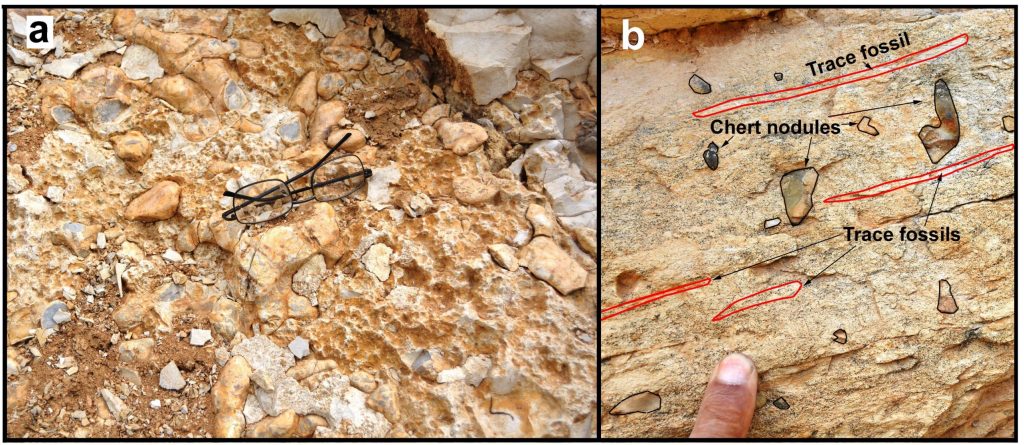
Figure 10- (a) Bedding surface shows stylolite peaks and pebble-sized chert nodules which are neither in shape nor in size related to Thalassinoides (b) A vertical section of a bed of glauconitic limestone at the top of Kometan Formation shows chert nodules lined vertical to the trace fossils (red lines).
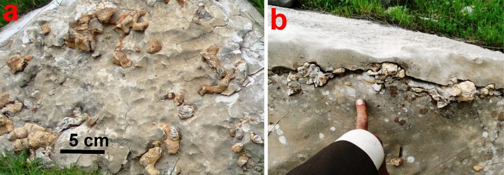 Figure 11- Various shape and sizes of chert nodules in Kometan Formation in Dokan area, (a) top view on the bedding plane, and (b) cross section view.
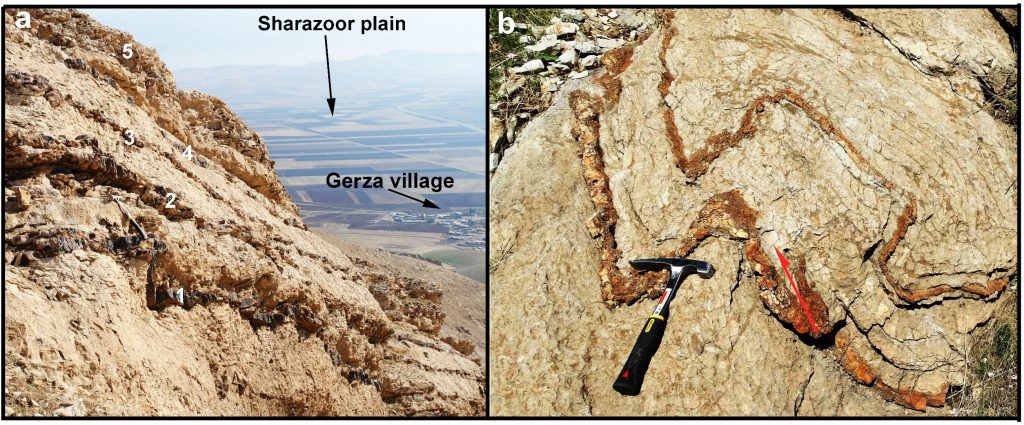 Figure 12- (a) Occurrence of five chert beds in an interval of 3m thick inside Kometan Formation on Greza Mountain. (b) Two folded chert beds in the latter formation near Said Sadiq town.
 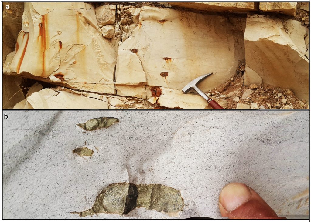 Figure 13- (a) Weathered and (b) fresh nodules of pyrite inside Kometan Formation directly at the west of Sulaimani city (Sherkozh Quarries)
3.2. Tectonic setting of Zagros chalky limestone (Kometan Formation)
There are agreement among researchers that the New Tethys sea (or ocean) is tectonically divided to oceanic and foreland basin episodes (Alavi 2004, Karim, 2004; Karim, and Surdashy, 2005; Jassim and Goff, 2006). The tectonic position of Kometan Formation within two episodes is controversial since some authors put the formation in the foreland basin while others placed it on continental margin of oceanic episode. Taha and Karim (2009), Karim (2013) and Karim et al. (2016) have put Kometan Formation on continental margin of New Tethys Ocean in a pre-obduction (collision) phase. On the other hand, Al-Qayim, et al. (2012), Al-Qayim (2012) and Lawa et al. (2011 in Al-Hakari, 2011) have cited that the foreland had developed before Turonian, which means that Kometan Formation deposited in the foreland episode.
Based on absence of fossils, Omer et al. (2015) indicated an unconformity that represented by disappearance of Dokan (late Cenomanian) and Gulneri Formations (Early Turonian). This research further added that during this unconformity ophiolite had obducted on Arabian passive margin. During the early Turonian, Lawa et al. (2011 in Al-Hakari, 2011) have mentioned that the Qulqula Radiolarian and main igneous complexes were uplifted and acted as Hinterland for Kuudistan Foreland basin. Under the title of “Turonian (base-AP9) Unconformity” Lawa et al.(2013, p81) documented unconformity formed as a result of uplift associated with the emplacement of allochthonous thrust sheets (Mawat ophiolites, Qulqula Group and Avroman Limestone) over the Arabian passive margin. They further added that thrust loading resulted in the formation of the Kurdistan foreland basin in which Kometan Formation has deposited (see p92 of latter article). However, Lawa (2018, p13) opposed his earlier ideas and mentioned that the obduction occurred during Middle Campanian which previously confirmed Taha and Karim (2009, Fig.15a).
The present study does not agree with above timing of the Foreland basin since it had developed after deposition of Kometan Formation (during Campanian-Maastrichtian) (Fig.15). This timing aided by many paleontological and sedimentological evidences such 500 m boulder and gravel conglomerate with red clastics that deposited during Maastrichtian and studied by Karim (2004), Karim, and Surdashy (2005) and Karim et al. (2013).
Paleontologically, Khafaf, (2014), Karim et al. (2013) and Karim et al. (2016) concluded that both Dokan and Gulneri Formation are occurring in all area of northeastern Iraq and there is no unconformity in the sequence of Upper Cretaceous (Fig. 14, 15 and 16). Baziany (2014) found the radiolarian of Cenomanian inside Qulqula Radiolarian Formation at Chwarta area, which mentioned continuous deposition of radiolarites (very deep facies) up to middle Cenomanian. In this connection, Ali et al. (2016) have aged crystallization of Kata Rash volcanic rocks, in Penjween area, to be Albian in Supra Subduction Zone setting. They added that it crystalized in the Neotethys Ocean rather than at a continental margin. Thus the Ophiolite obduction during Cenomanian, in northern Iraq, does not agree with result of Ali et al (op cit).
There are three other facts that do not aid deposition of the Kometan Formation during foreland episode. The first one is deposition of similar facies (Chalk Group) in Europe during Cenomanian (Mortimore, 2001) and more before development of Foreland basin in Europe. In Iran, Razin et al. (2010) did not record unconformity during study of the sequence stratigraphy of the Cenomanian and Turonian. The study added that the thickness of the Late Cenomanian-Early Turonian rocks ranges 15-35 m and consist of bioclastic facies of platform margin and intra-shelf basinal facies. In Syria Ghanem and Kuss (2013) record the biozones of the boundary of the latter two ages. The second fact is that no one has shown photo or direct evidence to indicate unconformity below Kometan Formation. The third fact is that in the field the present authors – distinguished easily the presence of Gulneri and Dokan Formations (Fig.14).
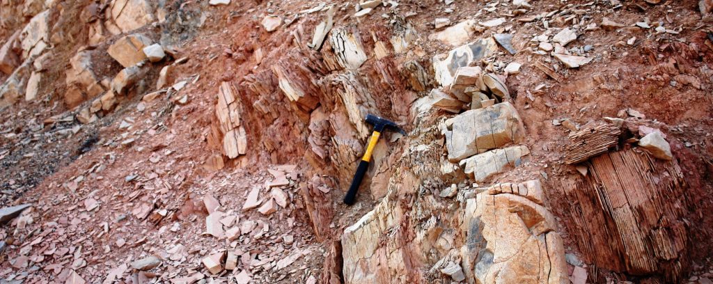 Figure 14- Gulneri Formation along road cut on Salta Re hill at 3 km north of Sulaimani City, it consists of grey marly limestone and laminated red marl
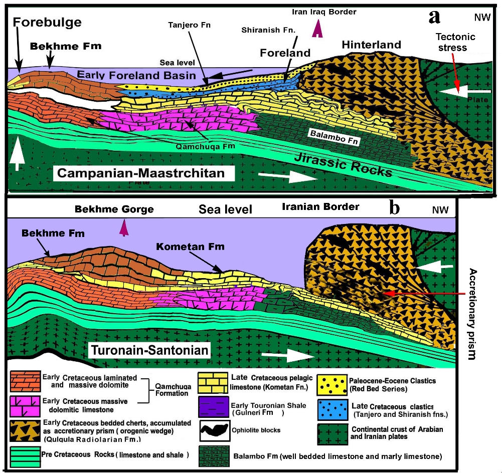 Figure 15- Tectonic mode shows deposition of Kometan Formation on continental margin of Neo-Tethys Ocean (a) before generation of Foreland basin (b), modified from Taha and Karim (2009) and Karim (2013).
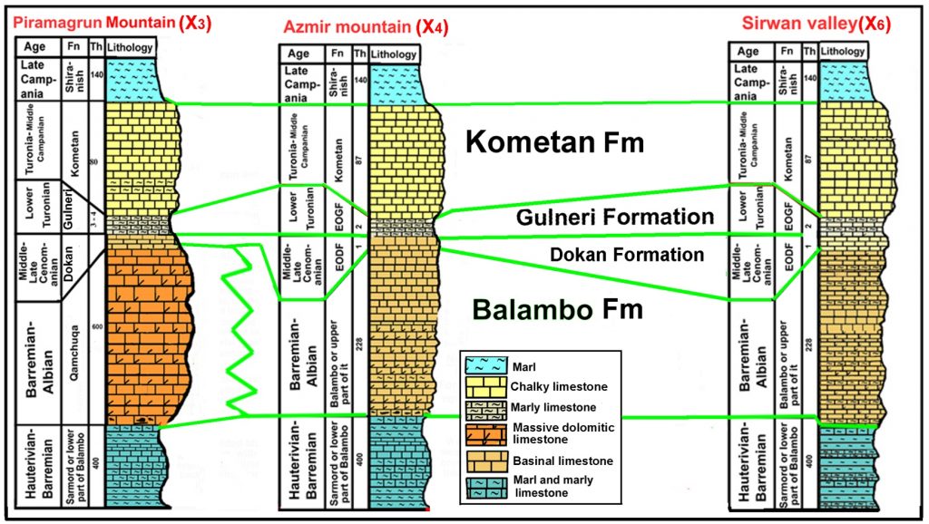 Figure 16- Correlation over more than 60km in the Sulaimani Governorate shows that both Dokan and Gulneri Formation are occurring and absence of unconformity. On the figure 1, the sections are indicated by X3, X4 and X6 for Piramagrun, Azmir and Sirwan valley sections respectively.
- Conclusions
1-The previous studies attributed presences of extensive chert nodules to replacement of Thalassinoides, however, the present study does not aid this replacement.
2-The previous massiveness of the Turonian-Middle Campanian chalky limestone is refused and changed to the well bedding.
3-The chert nodules and stylolites are formed during burial of the rocks and not related to Thalassinoide burrow .
4- The depositional well bedding property of Kometan Formation is intrinsic characteristic of the formation in its entire outcrops without exception and differentiable from pseudo-bedding.
5-In addition of nodules, Kometan Formation contains beds and laminae of chert.
6- Kometan Formation has deposited on continental margin of Neo-Tethys Ocean (sea) not in Zagros Foreland Basin as cited by many previous researchers.
References
Adabi, M. H. and Mehmandosti, E. A., 2008. Microfacies and geochemistry of the Ilam Formation in the Tang-E Rashid area, Izeh, S.W. Iran. Journal of Asian Earth Sciences, Vol. 33, p.267–277.
Al-Ameri, T.K. 2011. Khasib and Tannuma oil sources, East Baghdad oil field, Iraq, Marine and Petroleum Geology, 28(4): 880-894.
Al-Badrani, O.A., Karim, K.H. and Ismail, K.M. 2012. Nannofossils biozones of contact between Kometan and Shiranish Formations, Chaqchaq Valley, Sulaimanyia, NE- Iraq. Iraqi Bulletin of Geology and Mining, 8(1): 19-29.
Al-Barzinjy, S.T. 2008. Origin of chert nodules in Kometan Formation from Dokan area, Northeast Iraq. Iraqi Bulletin of Geology and Mining, 4(1): 95-104.
Al-Hakari, S.H.S. 2011. Geometric Analysis and Structural Evolution of NW Sulaimani Area, Kurdistan Region, Iraq. Unpublished PhD Thesis, University of Sulaimani, 309p.
Alhamdani, A.M. 2015. Pseudo-bedding and burrow silicification in the Kometan Formation of the Dokan area, Northeastern Iraq. Arab J Geosci, 8:325–333.
Ali, S. A., Ismail, S.A., Nutman, A. P., Bennett, V. C., Jones, B. G., Buckman, S. 2016. The intra-oceanic Cretaceous (~108 Ma) Rata–Rash arc fragment in the Kurdistan segment of Iraqi Zagros suture zone: Implications for Neo-Tethys evolution and closure, Lithos 260: 154–163.
Al-Khafaf, A. O. 2014. Biostratigraphic contribution to the differentiation of the Lower-Middle Cretaceous units in the Imbricated Zone of Sulaimani Governorate, Kurdistan Region, NE Iraq, PhD thesis, University of Sulaimani, 230p.
Al-Qayim, B. 2012. Foreland Basin System of the Northeastern Arabian Margin, Kurdistan Region, Iraq ; Impact on Oil Accumulations, EAGE Workshop on Iraq, Hydrocarbon Exploration & Field Development, IR03,Istanbul,Turkey, (earthdoc.eage.org/publication/-download/?publication=58878).
Al-Qayim, B., Omer, A. and Koyi, H. 2012. Tectonostratigraphic overview of the Zagros Suture Zone, Kurdistan Region, Northeast Iraq, GeoArabia, 17(4):109-156.
Arthur, M.A., Bottjer, D.J., Dean, W.E., Hattin, D.E., Kauffman, E.G., Pratt, L.M., Scholle, P.A. 1986. Rhythmic bedding in Upper Cretaceous pelagic carbonate sequences: Varying sedimentary response to climatic forcing. Geology, 14 (2): 153-156
Baziany, M.M. 2013. Depositional Systems and Sedimentary Basin Analysis of the Qulqula Radiolarian Formation of the Zagros Suture Zone, Sulaimani Area, Iraqi Kurdistan Region. PhD Thesis, College of Science, University of Sulaimani, 200p.
Bellen, R.C.V., Dunnington, H.V., Wetzel, R., and Morton, D. 1959. Lexique Stratigraphique, Interntional. Asie, Iraq, Vol. 3c. 10a, 333p.
Bromley, R. G. 1967. Some observations on burrows of Thalassinidean Crustacea in chalk hardgrounds. Geological Society of London Quarterly Journal, 123:157-182.
Bromley, R.G. and Ekdale, A. A. 1984. Trace fossil preservation in flint in the European chalk, Journal of Paleontology, 58( 2): 298-311.
Buday, T. 1980. the Regional Geology of Iraq, Volume 1: Stratigraphy and Paleogeography, Kassab II.M and Jassim SZ. (Eds.), GEOSURV, Baghdad, Iraq, 445p.
Ghafor, I.M., Karim, K.H. and Baziany, M.M. 2012. Age determination and origin of crenulated limestone in the eastern part of Sulaimaiyah Governorate, Kurdistan Region, NE-Iraq. Iraqi Bulletin of geology and Mining, 8 (2):21-30.
Ghanem, H. and Kuss, J. 2013. Stratigraphic control of the Aptian–Early Turonian sequences of the Levant Platform, Coastal Range, northwest Syria, GeoArabia, Gulf PetroLink, Bahrain, 18(4): 85-132.
Giannetti, A., Monaco, P., Caracuel, J.E., Soria, J.M. and Yébenes, A. 2007. Functional morphology and ethology of decapod crustaceans gathered by Thalassinoides branched burrows in Mesozoic shallow water environments.3rd Symposium on Mesozoic and Cenozoic Decapod Crustaceans – Museo di Storia Naturale di Milano, Volume 35, Fascicolo 2.
Hadavi, F. and Moghaddam, M. N. 2011. Calcareous nannofossils from chalky limestone of upper Abderaz Formation and lower part of Abtalkh Formation in the Kopet-Dogh range NE Iran, Arabian Journal of Geosciences 4(7): 1041–1049.
Jassim, S.Z. and Goff, J.C. 2006. Geology of Iraq. Dolin, Prague and Moravian Museum, Berno. 341pp.
Karim KH, Lawa FA and Ameen, BM (2001) Upper Cretaceous Glauconite filled boring from Dokan area. Kurdistan Region (NE-Iraq), Kurdistan Acadimician Journal (KAJ) 1 (1): 1-10.
Karim, K. H. 2013. New geologic setting of the Bekhme Formation. Journal of Zankoy Sulamani (JZS), 15 (3): 23-38
Karim, K.H. and Surdashy, A.M. 2005. Tectonic and depositional history of Upper Cretaceous Tanjero Formation in Sulaiumanyia area, NE-Iraq. Journal of Zankoy Sulaimani, 8(1):1-20.
Karim, K.H., Al-Hamadani, R.K. and Ahmad, S.H. 2012. Relations between deep and shallow stratigraphic units of the Northern Iraq during Cretaceous. Iranian Journal of Earth Sciences, Islamic Azad University, Mashhad Branch, 4(2): 93-103.
Karim, K.H., Al-Khafaf, A.O. and Sharbazheri, K.I. 2016. Critical analysis of the type section of the Balambo Formation (Valanganian-Turonian), Sirwan valley, Kurdistan Region, NE-Iraq, Journal of Zankoy Sulaimani – Part A, special issue.
Karim, K.H., Ismail, K. M. and Ameen, B.M. 2008. Lithostratigraphic study of the Contact between Kometan and Shiranish Formations (Upper Cretaceous) from Sulaimani Governorate, Kurdistan Region, NE-Iraq. Iraqi Bulletin of Geology and Mining 4 (2): 16 -27.
Karim, K.H., Salih, A.O., and Ahmad, S.H. 2013. Stratigraphic Analysis of Azmir-Goizha anticline by Nannofossils. Journal of Zankoy Sulamani (JZS), 15 (2):103-124.
Karim, K.H., Koyi, H., Baziany, M.M. and Hessami, K. 2011. Significance of angular unconformities between Cretaceous and Tertiary strata i n t he northwestern segment of the Zagros fold–thrust belt, Kurdistan Region, NE- Iraq. Geological Magazine, Cambridge University Press, 148 (5-6):925-939.
Kennedy, W. J. 1967. Burrows and surface traces from the Lower Chalk of Southern England. Bulletin of the British Museum (Natural History) Geology, London. 15 (3):127-166.
Lawa F A (2008)Late Campanian–Maastrichtian sequence stratigraphy from Kurdistanforeland basin, NE/Iraq, Journal of Petroleum Exploration and Production Technology, https://doi.org/10.1007/s13202-017-0424-1.
Lawa, F.A. and Gharib, H. 2010. Cretaceous Sequence Stratigraphy of Western Zagros Outcrops from Kurdistan Region, N. Iraq. AAPG GEO 2010 Middle East Geosciences Conference & Exhibition March 7-10, 2010–Manama, Bahrain (only abstract available).
Lawa, F.A., Koyi, H. and Ibrahim, A. 2013. Tectono-stratigraphic evolution of the NW segment of the Zagros fold-thrust Belt, Kurdistan, NE Iraq. Journal of Petroleum Geology 36 (1): 75–96.
Mangen, W. 2010. Physical principles of Sedimentary basins analysis, Cambrigde University Press, p.379.
McCall,1982. Animal-Sediment Relations: The Biogenic Alteration of Sediments. Springer Science & Business Media, Nov 11 – Science – 336 p.
Mortimore, R.N., Wood, C.J. and Gallois, R.W. 2001. British Upper Cretaceous Stratigraphy, Geological Conservation Review Series, No. 23, Joint Nature Conservation Committee, Peterborough, 558 pages, see: http://www.jncc.gov.uk/page-2969.
Mülayim, O., Mancini, E., Çemen, İ. and Yilmaz, İ. Ö. 2015. Upper Cenomanian-Lower Campanian Derdere and Karababa formations in the Çemberlitaş oil field, southeastern Turkey: their microfacies analyses, depositional environments, and sequence stratigraphy, Turkish Journal of Earth Sciences, 24: 1-17.
Myrow, P.M. 1995. Thalassinoides and the Enigma of Early Paleozoic Open-Framework Burrow Systems. PALAIOS, 10: 58-74.
Omar, A.A., Lawa, F.A. and Sulaiman, S.H. 2015. Tectonostratigraphic and structural imprints from balanced sections across north-western Zagros fold-thrust belt, Kurdistan Region, NE Iraq. Arab J Geosci. 8 (10):8107-8129
Pak, R. and Pemberton, S.G. 2003. Ichnology of the Yeoman Formation; in Summary of Investigations, Volume 1, Saskatchewan Geological Survey.
Razin, P. Taati, F. and van Buchem, F.S.P. 2010. An outcrop reference model for the Arabian Plate platform margins (Sarvak Formation) in the High Zagros, SW Iran: Sequence stratigraphy of Cenomanian-Turonian carbonate. Geological Society, London, Special Publications, 329: 187-218
Sarı, B., Ozer, S. 2002. Upper Cretaceous stratigraphy of the Beydag_ları carbonate platform, Korkuteli area (Western Taurides, Turkey). Turkish Journal of Earth Sciences 11: 39-59.
Sarı, B., Steuber, T., Ozer, S. 2004. First record of Upper Turonian rudists (Mollusca, Hippuritoidea) in the Bey Dag_ları carbonate platform, Western Taurides (Turkey): taxonomy and strontium isotope stratigraphy of Vaccinites praegiganteus (Toucas, 1904). Cretaceous Research, 25: 235-248.
Sieveking, G. de G.,. Hart, M. B. 2011.The Scientific Study of Flint and Chert: Proceedings of the Fourth International Flint Symposium, Cambridge University Press, 306pp.
Senemari, S. Tahrani, M.B. and Mhammadi, F. 2014. Nannofossil events and stratigraphy of the Ilam Formation in Zagros (SW Iran), Rivistab Italia di Paleontogia e Stratigraia, 120(1):103-108.
Sissakian, V.K. 2000. Geological map of Iraq. Sheets No.1, scale 1:1 000 000, 3rd edit., GEOSURV, Baghdad, Iraq.
Stevens, T., Paull, C.K., Ussler W.I.I., McGannn, M., Buylaert. J.P. and Lundsten, E. 2014. The timing of sediment transport down Monterey Submarine Canyon, offshore California. Geological Society of America. Bulletin, 126(1-2): 103-121.
Taha, Z. (2008) Sedimentology of Late Cretaceous Formation from Kurdistan Region, NE−Iraq, Unpublished, M.Sc thesis, University of Suilaimani.150 pp.
Taha, Z.A. and Karim, K.H. (2009) Tectonical history of Arabian platform during Late Cretaceous An example from Kurdistan region, NE Iraq. Iranian Journal of Earth Sciences, 1(1): 1-14.
Thomas, D.J. and Tilghman, D. 2013. Transient increase in proto-Indian Ocean upwelling during the Cenomanian/ Turonian OAE2, American Geophysical Union, Fall Meeting 2013, abstract #PP54B-04.
Walness, H.R. 1979. Limestone response to stress: Pressure solution and dolomitization. Journal of Sedimentary Petrology, 49(2): 436 – 462.
